I recently [re]discovered the years and years of accumulated GPS logs that I had from dragging my GPS with me on every hike or drive and decided to do something with them. After some Perl scripting and ImageMagick processing, I got this:
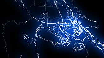
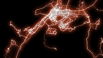
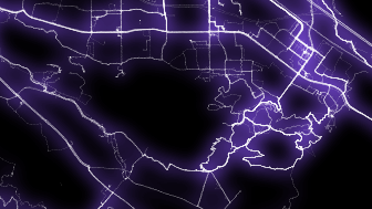
Click on the picture above for a full size view of this and other images.
BTW, this is my first diary entry - I hope the HTML works... If not, the URL is this: http://avtanski.net/projects/gps. The track visualization video is here: http://www.vimeo.com/23697355
讨论
olejorgenb 于 2011年05月26日 03:26 的评论
Nice! I really should clean up and organize my tracks, and this gives me some much needed motivation :) (I have not even close to that many track points though)
durian 于 2011年05月26日 05:48 的评论
Yes, nice! I did something similar with my tracks last year, plotted all my logs with Mapnik. I didn't filter them enough though so I got big clumps where I live and work.
SB79 于 2011年05月26日 06:51 的评论
Nice! How did you produce the video? Did you use imagemagick in order to produce the video by concatenating the pictures? :-)
maximeguillaud 于 2011年05月26日 07:43 的评论
Very nice ! Note that the -INPUT parameter doesn't work properly, it seems to always fall back to the "input" directory.
SB79 于 2011年05月26日 12:50 的评论
I can confirm this problem. The "INPUT" parameter doesn't work for me either.
Alexander Avtanski 于 2011年05月26日 15:21 的评论
Hello. Yes, I used ImageMagick - to produce the fuzzy glow effect. I merged the video from the images using VirtualDub.
Regarding the INPUT parameter not working - oops, my bad. The parameter is actually "SRCDIR". I'll update the README.TXT. Thanks for the tip.
Alexander Avtanski 于 2011年05月26日 15:45 的评论
UPDATE: Thanks for the feedback. I updated the README.TXT to list the correct parameter (SRCDIR instead of INPUT) and included in the zip file on the site a sample script that uses ImageMagick to produce the halo effect.
Hawkeye 于 2011年05月26日 17:21 的评论
I assure you, that was no waste of time or computing power! :-)
Anna_AG 于 2011年05月27日 12:54 的评论
Love it - agreed - no waste of time - what are computers for?
Windsurfer62 于 2011年05月28日 07:10 的评论
Great - It deserves to be used everywhere.
Claudomiro 于 2011年05月29日 01:26 的评论
This is so coool, pure art! Congratulations
qaysedcftgb 于 2011年06月 2日 22:42 的评论
GREAT!
I enjoyed the show. Grats!
gecho111 于 2015年03月 3日 00:25 的评论
Are the RUNNER parameters used generate a sequential series of images for a track? I can’t quite figure out how to use them.
Alexander Avtanski 于 2015年03月 4日 20:27 的评论
Hi,
Sorry for the late reply - I’ve been down with the flu.
The runners parameter just specifies a bunch of points where the trail should end - they correspond to the bright doors on the video. They do not generate a sequence of images. If you want a sequence, you need to run the script multiple times, each time with the runners moved a few points ahead.
It’s a bit tricky. However, I have written another tool that can be help generate any kind of movie - you can check it here:
http://avtanski.net/projects/gpsmash/
The easiest way to make an animation is to project the GPS data, export it to X3D format, load it in any 3D animation tool (like Blender, free) then animate any way you want:
http://avtanski.net/projects/gpsmash/example_outx3d.html
gecho111 于 2015年03月 7日 18:01 的评论
Thanks. Last year over the course of 73 bike rides totaling about 4000 km I covered every road and alley in my city. I thought it would be neat if I could create video drawing the path I took.