شعار خريطة الشارع المفتوحة خريطة الشارع المفتوحة

يومية BharataHS

إدخالات يوميات حديثة

State of the map Asia - 2017 and talk on multilingual maps of the world!

نُشِر بواسطة BharataHS في 22 سبتمبر 2017 باللغة English

Excited to be attending and presenting at the State of the Asia - 2017 conference for the first time at Nepal. I will be talking on Sunday (24th September) about how we are building multilingual map of the world by linking OpenStreetMap with Wikidata - an amazing open data project by Wikimedia foundation. If you are interested about this, attend the talk in Banyan hall at 11:15 AM on Sunday, 24th.

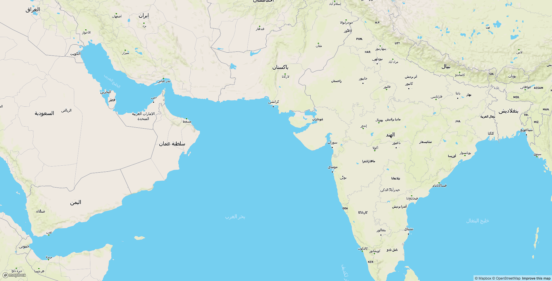
Arabic map of the world. (View full screen map)

See full entry

الموقع: Dulal Tol, Budhanilkantha-05, Budhanilkantha, Budhanilkantha Municipality, Kathmandu, Bagamati Province, 22644, Nepal

Scaling the matching of Wikidata to OpenStreetMap with wikimama

نُشِر بواسطة BharataHS في 30 يناير 2017 باللغة English

The OpenStreetMap community has been adding wikidata tags to OpenStreetMap features for the last several months. Linking OpenStreetMap features to Wikidata can leverage both projects to create novel applications such as multi-lingual maps and integrate other semantic information which OpenStreetMap doesn’t have but Wikidata provides.

Till date, over 400K features have a wikidata tag. The integration of linking wikidata within iD and JOSM editors allowed mappers to efficiently map wikidata tags but the biggest challenge is to focus on the best match for cases when location or names do not exactly match.

This post will walk you through using wikimama, a tool to find and add missing wikidata tags in OpenStreetMap.

Matching Wikidata tags in neighborhoods with ‘wikimama’

Let’s say you want to get a list of all neighborhoods/suburbs within Stuttgart that don’t have a wikidata tag and get a list of wikidata tag matches. The wikimama tool gives you this list that you can manually review and later add to OpenStreetMap.

  • Get the information of Stuttgart in OpenStreetMap

See full entry

Fixing the invalid areas of the map

نُشِر بواسطة BharataHS في 25 نوفمبر 2016 باللغة English آخر تحديث في 28 نوفمبر 2016

A previous diary post-The invalid areas of the map introduced us to invalid relations formed due to multipolygon relation being broken due to various errors. The post has a comprehensive discussions on different errors, its severity and respective simple fixes. It also has these interesting open questions which needs to be debated.

It seems like a huge majority of the issues need to be carefully reviewed by hand and cleaned up. What does a realistic approach to clean the map look like?

The flexibility of the current map editors allows mappers to continue to create features that don’t make sense like a way tagged as a forest. Is it time for stricter validity checks on uploads?

The current diary post walks through the tools which aids in fixing these invalid multi polygon relations which not only remains erroneous part of the map but also affects the map rendering.

Start by reading this documentation on multipolygons if you are trying to understand the basics.

How to identify invalid multipolygons ?

An error debugging tool from Geofabrics - OSM Inspector tool aids in identifying these invalid relations in OpenStreetMap. The tool can be either used in a web browser interface or as a layer in JOSM editor.

To use OSM inspector in a web browser,

  1. Go to http://tools.geofabrik.de/osmi
  2. Select Areas from ‘View’ menu.
  3. Left panel contains the list of all possible errors which enables user to toggle between errors.
  4. The map window highlights the node causing error and allows user to pan, zoom over the map in order to inspect the affected portion of the relation.
  5. The Selection panel at the right edge of the page displays the selected object and the small icons on the top leads you to map editors where one can fix the issue and also to open OpenStreetMap.

See full entry

Offset database for Bing satellite imagery in Taiwan

نُشِر بواسطة BharataHS في 26 أكتوبر 2016 باللغة English

Our data team at Mapbox along with the OSM-TW community recently completed mapping and aligning road network in Taiwan. The realignment was carried out mainly based on newly rendered Mapbox satellite imagery and Bing imagery.


Progress over Taiwan during road network realignment.

During this project, we observed offsets in Bing imagery in several areas when compared with Strava and GPS traces. All these offsets are now included in the Imagery Offset Database for the wider community to use.

See full entry

Open tools to improve OpenStreetMap for navigation in France

نُشِر بواسطة BharataHS في 19 سبتمبر 2016 باللغة English

A review of the existing data in 5 most populated cities of France was detailed in our previous diary. Through this diary, we will be introducing you all to a handy tool for mapping turn restrictions.

Adding turn restrictions using OSM Navigation Map

OSM navigation map is an open tool that was built to review and add missing data for turn restrictions. It relies on Mapillary as a source to identify the turn restrictions in the detected traffic signages from the street level images captured by the volunteers.

The data team in Mapbox has used this tool for reviewing the existing restrictions and as well adding the missing ones for US cities, 5 cities each in Canada and Germany. The tool assists in reviewing the restrictions easily and quickly.

detected_only_right_turn Detected signage of only_right_turn restriction in Mapillary

See full entry

Reviewing navigation data in France

نُشِر بواسطة BharataHS في 9 سبتمبر 2016 باللغة English آخر تحديث في 19 سبتمبر 2016

One of the prime applications of maps is navigation. In order to make OpenStreetMap more reliable for navigation, the team Mapbox has been improving the data in the map by adding missing turn restrictions, exits and destinations across the world. Recently, we mapped most of the gaps in the data across US cities as well as 5 cities each in Canada and Germany. In the entire process, we worked closely with the local community by taking inputs in the form of suggestions and guidance on improving our workflow and resources.

Continuing from our previous work in Europe, we did an initial research on France to get estimate of existing navigation data. These are the 5 cities we want to start with,

screen shot 2016-09-09 at 7 42 57 pm

Our initial assessment shows that there are very few turn-restrictions mapped overall, and a majority of what is present is “only-straight” or “only-right” rather than the common “no-right-turn” or “no-left-turn”.

Data Sources for Mapping

Mapillary Imagery

See full entry

Field mapping at Indiranagar, Bengaluru

نُشِر بواسطة BharataHS في 1 أغسطس 2016 باللغة English

Field mapping!

Though we have high resolution satellite imageries and robust tools to digitise a map, we end up not tracing many features due to lack of visibility or some errors or covers. The only solution if an area has to be mapped completely and precisely is field mapping.

Last week a team of 6 involving Srividya, Krishna, Maanya, Amisha, Upendra and I decided to head out for field mapping at 12th main road in Indiranagar, Bengaluru. We aimed at collecting building details, building levels, Point of Interests (POIs), trees and street lights. We walked for more than 3km and tracked our ways using smartphone applications, mainly OSMTracker.

thumb-2048 1

See full entry

Mapping my hometown

نُشِر بواسطة BharataHS في 11 يوليو 2016 باللغة English

I have been mapping my hometown for quite a while now. This is where I am residing since birth and had my education in and around Gubbi. In Kannada language the term is related to a sparrow bird (ಗುಬ್ಬಚ್ಚಿ) . The town has a history of more than 150 years. This is the place from where I would love to start mapping.

About Gubbi

Gubbi is geographically about 100km to the west of Bengaluru, the capital of Karnataka. The national highway NH-73 (previously NH-206) (Also known as Bengaluru - Honnavara Road) runs along Gubbi. The population of the Gubbi Town is 18, 457 as per Census 2011. The total area of the Town is 6.67 sq. km.

Status of map before putting my hands

screen shot 2016-07-07 at 11 45 50 am

This was how map of Gubbi looked before I started mapping

Most of the basic amenities and road networks in and around Gubbi was already on OSM. I thank OSM community for their contributions to the map around Gubbi.

The areas I worked on

See full entry

الموقع: Gatti Layout, Gubbi, Gubbi taluk, Tumakuru, Karnataka, 572216, India