
Well I'm stuffed. Did 64km on the bike today tracing out country roads in the name of cycle touring training. I estimate that about 45km of extra roads were added as a result of this exercise.
If the OSM history viewer decides it's able to visualise the changeset it can be seen here.
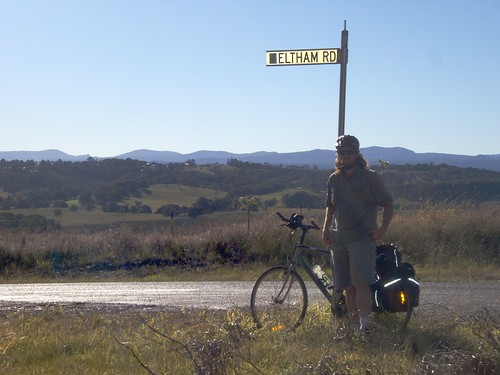
Otherwise I added: Boat Harbour Road, part of Eltham Road (then added the rest from Landsat), McKenze Road, Pearson Road, Cowlong Road, Alphadale Road and Tregeagle Road.
Cameron Road (joins Boat Harbour Road and Cowlong Road) was added as it's an ABS suburb boundary.
I've done 270km on the pushbike since moving to Lismore 8 days ago. Time to do nothing for a few days :p.
For some reason the osmarender layer is playing up. It's viewable through informationfreeway.org if you select the Firefishy proxy though.
If anybody's interested the motionbased.com analysis of the (very simplified) GPX track is here
Also, I feel like throwing in this photo of me on the road (yeah, the flash fired to try to fill-flash...all it did was blow out the reflective strips :p):
การอภิปราย
ความคิดเห็นจาก Rhubarb เมื่อ 5 กรกฎาคม 2009 เมื่อเวลา 06:11 น.
The country side looks marvelous there!
Atleast there wouldn't be many POIs to stop and tag there, just street signs and perhaps bus stops :)
Have fun :D
ความคิดเห็นจาก awesm เมื่อ 5 กรกฎาคม 2009 เมื่อเวลา 11:56 น.
Yeah, it's a nice part of the world. Must be somewhat challenging on a bike. You'll enjoy Nightcap National Park when you get there. Ah, memories from so long ago …
ความคิดเห็นจาก Biogenesis_ เมื่อ 5 กรกฎาคม 2009 เมื่อเวลา 12:33 น.
Yeah, it's nice being able to cycle more than 50m before having to stop and photograph something.
It can be challenging in parts, but the area within ~40km of lismore isn't too bad. The elevation profile of this ride peaked at ~200m. And that was riding up a plateau then back down again. I once did a MTB ride out of Mullum that went from ~10m to...*drumroll*...820m*. I was dead for a few days after that one.
*Mullum -> Huonbrook, North Rocks Road, historic nightcap track, returning through the back of Huonbrook.
ความคิดเห็นจาก wamble เมื่อ 6 กรกฎาคม 2009 เมื่อเวลา 02:51 น.
When I was up there recently to look after my mother for a while, I had a daily (apart from a week with almost continual heavy rain) training ride out of Huonbrook to Mullum and back. It's a nice little heart-starter up Laverty's Gap.
ความคิดเห็นจาก Biogenesis_ เมื่อ 6 กรกฎาคม 2009 เมื่อเวลา 04:00 น.
Daily? Damn that's pretty heavy for a high intensity ride. Laverty's Gap had my heart rate at 180bpm for the whole climb in lowest gear on the MTB...Not tried it again since then.
ความคิดเห็นจาก wamble เมื่อ 7 กรกฎาคม 2009 เมื่อเวลา 01:55 น.
It was nice to see how my climbing improved over time. My total time went from about 1:24 to 1:18 over the course of a week (but stayed at around that time from then on). The virtual partner on the Edge is good for setting you a goal to try and beat.
ความคิดเห็นจาก Candid Dauth เมื่อ 2 ตุลาคม 2009 เมื่อเวลา 01:33 น.
Your changeset is finally viewable in OSM History Viewer. It was so big that I had to increase the memory limit in Java. ;-)