
Nothing personal, just GPS tracks
9 August 2016 کوں English وچ BushmanK دی طرفوں پوسٹ کیتا ڳیا. آخری واری 25 September 2016 کوں اپڈیٹ کیتا ڳیا.GPS tracks, contributed by OSM members still are sometimes very important source of information for mapping. However, built-in OSM database has certain issues, such as inability to delete obviously harmful data, such as airborne tracks, huge wandering spots, created by receivers in standing cars, etc. Currently, all responsibility for GPS data quality is on contributors, since they have to take care of getting rid of wandering spots, super-generalized tracks, tracks with high GDOP and so on before uploading it. While only a few people actually know about all these aspects and care about it. Complexity of track contribution process (at least, it’s not a”one click procedure”) makes fresh tracks more and more rare.
Strava heat map is another (often - way more dense) source of GPS tracks. But it’s limited by running and cycling activities.
For a long time, I’ve been saying, that any more or less popular mobile map/navigation application, which uses OSM data, can help to improve GPS tracks coverage. And being properly developed, it will not require any actions from its user, except giving his permission to record and upload tracks anonymously. It’s an ideal case, where valuable contribution could be fully automated and independent of user’s skills or knowledge. Set of simple filters (GDOP, top speed, geolocation source provider) can reduce consumed traffic and improve data quality.
And here is an example of tracks, collected for only a week by Yandex (major Russian web/mobile company) commercial applications. Note, how dense their point cloud is. And they updating their track layer, used for their own collaborative mapping project, every week.
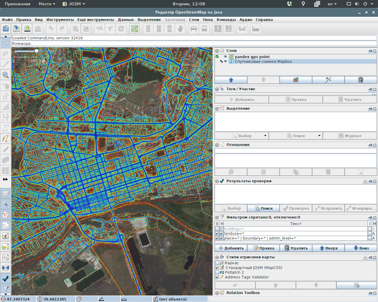 This screenshot was taken by OSM member luiswoo using Bing satellite imagery and Yandex GPS point cloud, which can not be used for OSM mapping.
So, keeping in mind all that recent controversy about contributions, made by untrained users of popular application, based on OSM data, I’d like to mention again, that voluntary GPS data contribution does not require any training, if track recording application is properly developed.
بحث مباحثہ
9 August 2016تے 19:25دے بارے escada دی رائے
With all those track accumulating websites, be it Strava or OSM, I wonder what their value is when you cannot filter tracks on date. Over time you will see a mix of tracks over no-longer existing paths and over the current paths.
I hope for you that Yandex does offer the capability to hide all tracks older than a certain date.
9 August 2016تے 20:36دے بارے BushmanK دی رائے
@escada,
Yandex tracks layer can only be used in their own collaborative mapping project, they don’t allow any third parties to use it. However, it always shows only tracks not older than a week. So I wanted to bring it as an example of amount of data that can be collected by popular navigation/mapping mobile apps.
10 August 2016تے 10:01دے بارے Vincent de Phily دی رائے
Currently all those track repositories are data silos, even in the rare case when the license allows extraction. It’d be great to have a sevice which would be good enough to be used by any willing party (say all osm-based satnav apps) in just a few lines of code.
Top of the head requirements:
Ouch, that’s actually a sizable amount of work. But it’d be worth it if it improves uppon the very fragmented sources that we currently have.
10 August 2016تے 11:24دے بارے Zverik دی رائے
Please mention that the layer pictured cannot be used for tracing into OSM, since it is protected by the copyright. We all understand it, but more recent contributors might get a wrong idea.
10 August 2016تے 13:38دے بارے BushmanK دی رائے
@Zverik,
As I said several times before: you can not read or you reading headlines only. It was in this diary entry from the beginning:
You know, how I’m always concerned about proper license, but I’m not going to target completely unaccountable people, since it’s impossible to prevent their unwanted activity with warnings.
10 August 2016تے 14:54دے بارے BushmanK دی رائے
@Vincent de Phily,
Even better contribution to existing OSM tracks storage can actually be helpful, without any new service. As I said, if data collection is under the full control of an app (or its part) intended exactly for OSM, quality can be improved dramatically.
11 August 2016تے 09:50دے بارے joost schouppe دی رائے
@marc but you can! For Strava, there’s this map. It looks like simply adding ?year=2015 should give you filtered data, though I can’t seem to be able to get it to work.