
Review of StreetComplete mobile app usage in the Ireland osm community
Posted by DeBigC on 29 June 2021 in English.StreetComplete was designed by Tobias Zwick and launched in 2016 as a handy “low-bar entry” field capturing application for OpenStreetMap. In the following 2-3 years it rapidly rose to have a share of 3.9% of contributors favoured application, since it requires no real prior expertise in OpenStreetMap. The beauty of it is that it exploits the opportunity of a mapper being in situ where some features have been mapped, but lack details about their attributes, and tags on the OpenStreetMap database.
The UX is good, even for the experienced mapper it masterfully detects the absence {not to jump down a rabbit hole, but very like my favourite Pink Floyd Album } of tagging details, and then it supports the insertion of the correct tags with menu systems that are visual rather than everything being list driven. Perfect for being on the move, a car passenger or a leisurely walker. This is not supposed to be a review of the app, but you can probably detect that I am a fan.
With some help from my friend Amanda who downloaded the .pbf, and extracted all the editor traces of StreetComplete here I was able to get hold of a csv of all of the Ireland edits and then use that to make a heatmap, with some help from RustyB. The heatmap shows, what we would expect, greater use of the app in Ireland’s cities and large towns.
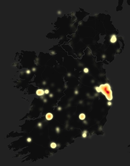
However, my expectations of the number of StreetComplete contributors, and the number of edits contributed in total were higher, and it was disappointing to learn that after five years was only 108,500 edits, and this done by 105 different contributors meaning an average of only 1,000 each. On the other hand, and typical of OpenStreetMap contribution statistics, there is a “long-tail” of contributions, where the vast majority are small contributions and 80% of the work is done by the top 10 users.
| User | Edits |
|---|---|
| cart0 | 26878 |
| ag-nius | 11627 |
| DaCor | 10555 |
| DeBigC | 8612 |
| b-unicycling | 7628 |
| Florent Ch | 4024 |
| tshedy | 3531 |
| kenguest | 3105 |
| Dr Breandán Anraoi MacGabhann | 1627 |
| desfitzgerald | 1428 |
Being very involved in the #osmIRL_buildings project I found that the app works in the perfect context to help tag newly added buildings, where we are still using satellite imagery to capture buildings it is unavoidable that some high percentage of them will be building=yes. Looking deeper into into the extracted data is was interesting to discover that the objectives of #osmIRL_buildings were relevant to what a lot of StreetComplete activity was focused upon, with the following findings:
- 23,221 edits related to the “building” value key
- 24,773 edits were to define a roof type, or levels within the roof
- 15,163 edits were to add the building levels
- 6,887 edits related to adding the address in either house number or housename
- 3,559 edits related to the addition of a placename or streetname to a building address
Overall I think StreetComplete is a useful and very handy tool, but I do think the Ireland OpenStreetMap community could embrace it more. In particular there are 700,000 or more building=yes tags on the island, and this challenge needs to be addressed to get towards a useful and scalable building dataset. More StreetComplete surveyors doing more walks and cycles, and contributions into the black fog of absent attributes is needed in the future.
Discussion
Comment from westnordost on 29 June 2021 at 14:57
Cool, very interesting analysis!
Yeah, OpenStreetMap is very much more carried by few users (“power mappers”) with a lot of contributions than many users with each only a few contributions. This fact is not so obvious when looking at the map per se, because most of what can be seen on the map itself is traced from home, i.e. it doesn’t matter where exactly the user resides but it becomes obvious when looking at where edits are made that require the user to be on-site.
StreetComplete set out to lower the barrier for initial contribution in order to unskew that statistic a bit, but of course, there is only so much impact one app can have.
People who get the app for example but are not registered on OSM yet, for example, need to overcome the hurdle to register an account at OSM first before they can really contribute. The registration is unnecessarily tedious, especially on mobile, so a lot of users jump off before even making their first uploaded edit.
Comment from DIrish on 29 June 2021 at 15:16
I think that one of the biggest barriers to StreetComplete being adopted more is the lack of an iOS version. I wonder if there are any plans to address this? It is an excellent platform.
Comment from westnordost on 29 June 2021 at 15:35
See https://github.com/streetcomplete/StreetComplete/issues/1892
Basically, it is possible but is a very large untertaking. What is missing is * Funding * Someone willing to maintain/extend the port afterwards
Comment from westnordost on 29 June 2021 at 15:36
(That was meant to be a list: 1. Funding, 2. maintainer, apparently kramdown doesn’t work)
Comment from DIrish on 29 June 2021 at 15:55
Thanks for explaining this and the barriers to the iOS version of StreetComplete. It’s a pity really because it would be a ‘game changer’.
Comment from b-unicycling on 29 June 2021 at 18:17
It’d be interesting to see how the lockdown affected the SCing.
Comment from westnordost on 29 June 2021 at 20:50
Difficult to look at that isolated. A lot of other things changed in the last year which pushed efficiency and user count of the app.
User count roughly doubled in the last year, while the number of contributions roughly quadrupled.
Comment from westnordost on 29 June 2021 at 20:50
Some statistics here: https://github.com/streetcomplete/StreetComplete/discussions/2671
Comment from DeBigC on 29 June 2021 at 21:32
@westnordost Thank you for you comments here today - I was thrilled to see you enjoyed the analysis. Back when you launched the app I was on the side of the argument that we need to change the hyper-local obsessions of mappers, and facilitate mappers who move around a bit and opportunistically can verify ground truth. Let’s face it, desktop mapping is fine but not the only way to do it.
The iOS point is one that several people in the community in Ireland will regularly raise. I don’t know about the commercial prospect of the app, but if you needed funding I would suggest osmf is asked about it. I do realise that there would be ongoing technical curation of it, much larger than you presently have to do.
Your stats for “Ireland” only show the Republic of Ireland. Our community on this island is unified into one, the only differences we have are slightly variant road signs, but we all know one another’s :). But seriously, Ireland is an osmf chapter encompassing the whole island.
It is awesome to see the growth in usage. I bet Covid-19 did that. I will do another post looking at the time-stamps on the edits and seeing if our trend for Ireland was upwards since last March when these lockdowns started.
Comment from kucai on 30 June 2021 at 02:18
Perhaps there are people like me who use Streetcomplete in conjunction with Vespucci. I use Streetcomplete to scan an area for potential edits since it loads much faster that Vespucci. When I get to the targeted area, I’ll switch to vespucci to edit ( a lot more options available).
Still thankful for Streetcomplete no doubt.
Comment from Strubbl on 30 June 2021 at 06:58
I use vespucci together with SC, but only for edits SC was not designed for.
Comment from listonv on 1 July 2021 at 08:23
What sort of funding is required to create an iOS version, assuming there was someone to maintain afterwards?
Comment from westnordost on 1 July 2021 at 12:39
Well I’d say most of the funding should also go to the one that maintains and extends it afterwards (and that won’t be me, it’s too much for one person).
As written in that ticket, it would take very roughly half a year for two people to port the app to iOS.
Comment from bryceco on 1 July 2021 at 13:24
If someone were being paid to port and maintain the app I’d favor doing so as a web app, so it’s device agnostic. I don’t know how that would affect the work estimate.
Comment from Mateusz Konieczny on 20 July 2021 at 08:23
It would require writing StreetComplete from scratch, though research put into quest and some interface ideas could be reused.
So I would expect it to be vastly increased, though maybe some minimum viable prototype could be done faster.
If going that route then likely making new editing set in MapComplete would be the best way to achieve this. And improve MapComplete rather than starting a brand new project.