OpenStreetMap logo OpenStreetMap

DeBigC's Diary

Recent diary entries

What's up with #osmIRL_buildings #3

Posted by DeBigC on 4 January 2025 in English.

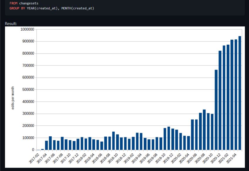
As time passes I am delving further into the discovery that I outlined here, and contextualised a little more here and all relating to the Fingal task set up by myself and the osm community three years ago.

In quantum of the problem there are new data available from the Heigit counting service. This shows that as the validation continued up to the 18th December 2024 when the task was a year old an additional 14 thousand missing buildings were added.

heigit3

Looking further into this missing building set it is distributed as follows by building tags:

*building=shed up 3700

*building=garage up 1800

*building=farm_auxiliary up 200

*building=service up 58

*building=ruins up 56

There is also some re-tagging of building objects from the building=yes tag, which mappers were requested to attempt to do.

See full entry

What's up with #osmIRL_buildings #2

Posted by DeBigC on 10 December 2024 in English. Last updated on 11 December 2024.

Here I go again…. part 2.

I was pleased to see someone pick up on my first diary item. OSM weekly is hardly the New York Times, yet I know that the editors like posts which are constructively critical, and they did spot that I was hoping for something to happen which would let us all “do better”.

I decided to look in more detail at how the lack of detail was leaving validators with a lot of mapping to do. Evidence of this is seen here, where the mapper marking the tile as “completely mapped” is nowhere near being the main contributor of objects and the validator – DeBigC – has add or adjust 62% of the objects in the tile. This shows the last mapper to touch any object. Screenshot-2024-12-11-112534 Note: I do accept that this is one tile, but it’s not unusual to find this all over the Fingal task.

See full entry

What's up with #osmIRL_buildings

Posted by DeBigC on 4 December 2024 in English.

Backround

About 6 years ago now, the Ireland OSM community had a bunch of online and face-to-face discussions. There was a desire to have a common campaign, rather than everyone just paddling their own canoe, mapping old boundaries, addding 110KV monster pylons, plotting the holy stones of Clonrickert, or whatever you are having yourself.

Why Buildings?

And so #osmIRL_buildings was born. It took lots of months to pull together. There was a discussion document put out, and lots of decisions and guidance via videos, long conversations on Telegram, and frequent issues discussed on the mailing lists. The task was designed with a few things in mind. Firstly, the community recognized that compared to other territories, we had relatively small levels of completion of buildings. Secondly, a prominent academic had stated that the Irish Government knew more about the number and condition of cattle than it did about buildings. Thirdly, a lot of citizen science projects were trying to collate and capture where derelict and disused buildings were located in cities, with the hope that they might be repurposed for housing. Fourthly, there was a National Planning Framework launched in 2018 that concluded that the spaces for the next 1 million people to live in could not be sprawl outside of Ireland’s cities and towns. There were other reasons too, but those are the ones I recall, so apologies to all those other reasons and their proponents. Nevertheless, all of the ones I mention here could have been addressed by the creation of a fully open spatial dataset of the buildings on the island, and not what passes for open data by data.gov.ie.

Reservations

Of course there were detractors; some mappers worried about the threat of being inundated by the glibness of millions of “building”=”yes” objects. One man in Kilkenny was worried that the climate would have changed by the time the task would finish. He might yet be right.

Kick Off

See full entry

Time to talk about landuse=residential

Posted by DeBigC on 4 April 2022 in English.

I have put the following item on the Irish mailing list. I will put it here to widen out the inputs. If you have some time, and some experience of adding this landuse. Rather than repeat all my concerns I will simply post visual some examples of the issues I am talking about here.

Example of an urban landuse=residential which is gigantic.

Example of a landuse=residential interpreted at running along a roadway to incorporate ribbon(roadside) developments. This landuse connects a huge number of disconnected places.

Example of a landuse=residential residential where the landuse is trimmed back from the public highway and walkway, and doesn’t extend beyond the collective block of properties.

My annual diary post from last year is here, for which the summary of the targets set back then is now:

  • I definitely stayed in the top 10 #osmIRL contributors for the whole year. There was more to that of course, as in 2021 I contributed more mapping days than ever before, missing only 16 out of 365.

  • In August 2021 I reached 200,000 contributions in 60 days, this is the most intense contribution to OpenStreetMap I have ever achieved, and i wrote about that here

  • I undertook “as an extra kick” to build a tool to visual osm for the whole island. This is here, but needs a bit more work, especially a process to keep it up to date. Thanks to Rusty and Amanda for helping plan and execute this.

  • I set myself a “not hard target” of raising my mapillary contributions to 1.5 million. While I did add around another 100k images mapillary changed a load of things about their upload process and web app in the year, making it nigh-on impossible for me to report exact numbers, and also leaving me with an upload queue that I carry into 2022.

  • I met my StreetComplete Target of raising myself to be #3 in Ireland. For most of the year I was #2 with huge early progress in the first #8 months. I am now #3 so this target is achieved.

  • I didn’t clear up all the gaps I mentioned, because a demon keeps asking me to help with bits of rural Ireland. However, I addressed a huge number of gaps in buildings that I didn’t already know about. From now on this task has the gaps and if you feel like helping me jump in there :)

My rating: Looking at these, using mild re-interpretations of the targets I am giving myself 4.5 out of 6. I didn’t fail completely in any area.

See full entry

Location: Botanic Garden, Glasnevin A ED, Dublin, County Dublin, Leinster, D09 VY63, Ireland

The view from the summit of 200,000

Posted by DeBigC on 28 August 2021 in English.

The helpful webstats that are provided by Pascal Neis measure map contributions per sovereign territory. In Ireland we still have a relatively small community, and would seldom have over 400 mappers appearing in his ‘kinda random’ 60 day view of the mapping contributions. It would also be rare to have over 100 map changes recorded by more than 100 of those who make it on to the chart. The pascal records these excludes Northern Ireland, who are part of our community, and where our active mappers also map a good deal.

Anyway, a few weeks ago myself and my fellow Traveller, AK challenged each other to get to the 200K mark. AK has been to that summit before, and me never, though it wouldn’t be uncommon for me to have 100K map changes. I am so thankful to have her comradeship and support. It became less of a race, and more of us egging one another on to map every day for the 60 days, which we duely did, and here is the proof. 200K

See full entry

Triskaidekaphobia in Dublin

Posted by DeBigC on 23 August 2021 in English. Last updated on 24 August 2021.

I map a lot of buildings in northern Dublin City. I also interrogate housenumber interpolations, view mapillary for little peeks of the housenumbers that aren’t blurred, and do my own StreetComplete captures to add as many address details as possible. Lately I have noticed something, born from a concern that I was doing something wrong, or making a mistake.

In a few housing developments around Dublin housenumber=13 doesn’t exist. I have heard of such indulgences before, for example some airlines dropping row 13 from seating plans, or the Irish car registration authority famously dropping its numeric system in 2013 to avoid the unluckiest of car numbers.

So out of curiousity I hit OverPass Turbo and launched a series of queries like this into the existing housenumbers. I couldn’t do loads of these so I thought that maybe 19 would be a sufficient sample (42,000 building objects) to make comparisons and establish patterns. snip1

See full entry

My intention

It is what it is. This is some feedback for the organizers, speakers and community at large. I’m just picking out my main impressions and experiences. I sat through about 80% of it except for a couple of the Sunday things. The conference, being the second remote one had a dead atmosphere about it, even judged by the remoteness yard-stick. I have always been remote, for various reasons, and I enjoyed Japan, Milan, Heidelberg, and even the shell of Cape Town last year from afar. In those years small glitches occured, but despite these things did improve and did get better with the passage of time.

My intention is to give positive feedback, without being a cheerleader because cheerleading is just noise, not specific and not credible. Positive feedback is honest, and helpful with its honesty.

The content

I think the speakers, their topics, the content decisions, the preparation, the enthusiasm and the concern for the rest of the community and the project shown by the speakers was exemplary. As a viewer of several SOTMs I can certainly see interests in the community maturing, specializing and upping its game in terms of evidence behind ideas, and explanation of these ideas, and calls for engagement. I don’t dare to pick out my favourites as I have 4 friends who presented, but there were talks that were surprisingly interesting, beyond how they were billed. This needs to be preserved, firstly by naming it for what it is, and maybe the process of selecting and focusing talks is working well.

The format

See full entry

StreetComplete in Ireland: part 2

Posted by DeBigC on 5 July 2021 in English.

This diary post is a follow up on the one I did last week here where I was looking at how much, and for what the Ireland OpenStreetMap community uses the StreetComplete(SC) app.

The StreetComplete creator Tobias replied showing an interesting worldwide trend for SC usage. The trend here shows that there has been an upturn in SC usage worldwide in the last couple of years in terms of the users and edits contributed:

changesets.jpg

In particular Tobias shows that co-incidental with the Covid-19 months that there was a big upturn in the changesets contributed, starting gradually in May 2020 with a doubling on the previous month, but continuing to rise until the changesets remained at about 4 times the normal level for the forthcoming year. Most users are in the Northern hemisphere, so to see the higher level of changesets sustained through the Northern Hemisphere’s winter months is impressive.

In Ireland the changes, as in the big upturn are also reflected in a little bit of analysis done here.

See full entry

StreetComplete was designed by Tobias Zwick and launched in 2016 as a handy “low-bar entry” field capturing application for OpenStreetMap. In the following 2-3 years it rapidly rose to have a share of 3.9% of contributors favoured application, since it requires no real prior expertise in OpenStreetMap. The beauty of it is that it exploits the opportunity of a mapper being in situ where some features have been mapped, but lack details about their attributes, and tags on the OpenStreetMap database.

The UX is good, even for the experienced mapper it masterfully detects the absence {not to jump down a rabbit hole, but very like my favourite Pink Floyd Album } of tagging details, and then it supports the insertion of the correct tags with menu systems that are visual rather than everything being list driven. Perfect for being on the move, a car passenger or a leisurely walker. This is not supposed to be a review of the app, but you can probably detect that I am a fan.

With some help from my friend Amanda who downloaded the .pbf, and extracted all the editor traces of StreetComplete here I was able to get hold of a csv of all of the Ireland edits and then use that to make a heatmap, with some help from RustyB. The heatmap shows, what we would expect, greater use of the app in Ireland’s cities and large towns.

See full entry

The evolution of adding buildings in Ireland

Posted by DeBigC on 31 March 2021 in English. Last updated on 2 April 2021.

The tag #osmIRL_buildings is a kind of handy brand name our community has developed for our mapping campaign to map all of Ireland’s buildings. The campaign started with a brief test at a single mapathon in Galway in September 2019, and kicked off in earnest in Kilkenny at the end of November the same year. I say “in earnest” because this is when tasks were opened and the tasking manager started to be used every day.

The campaign has a number of effects which merit discussion beyond just the obvious upturn in mapping. But let’s mention that upturn first. The upturn started at the same time as the task manager being opened at the end of 2019. The number of buildings went from 810k to 1.5million in those 15 months, which means 47 thousand buildings were added each month.

buildings
picnic images

See full entry

osmIRL_buildings merch

Posted by DeBigC on 15 March 2021 in English.

As a Director of OSM Ireland (osmIRL) chapter I occasionally get to do nice jobs for the community. Our chapter received a microgrant from the OpenStreetMap Foundation which we are using in conjunction with the agreed community task to map all 5+ million buildings on the island. With the support of this microgrant the chapter deployed the concept of rewarding mapping landmarks with a small token of appreciation for reaching the landmark of 10,000 buildings.

In this case we are giving our contributors a handy mouse mat, which is made with foam and nylon and carries a nifty design. Bias declaration: I designed it! mouse-matt.jpg

The background image is simply one part of suburban Dublin, showing the importance of adding buildings to the map. It also shows the campaign name #osmIRL_buildings. We have a task manager here to co-ordinate all this work.

See full entry

Location: Woodlawns, Kilmore A Ward 1986, Dublin, County Dublin, Leinster, Ireland