OpenStreetMap logo OpenStreetMap

Harry Wood's Diary

Recent diary entries

To help with deciding where to do London mapping parties, I've updated this map which shows all the past locations:

It clearly shows we're not travelling out from the centre so much in recent years, but there are reasons for this. Back in 2008 we had target areas glowing in red on the nonames (streets mapped from yahoo where we needed to at least go get the names), and we headed out, sometimes beyond zone two, to zap them. Throughout 2009 this became quite difficult as the patches of remaining unnamed streets were too far out. These days they've all been obliterated, although I suspect the last pockets (such as Hillingdon) were probably filled in by people OS streetview copying without going there.

See full entry

Soho & Mayfair mapping, and pubs and burritos

Posted by Harry Wood on 20 June 2011 in English. Last updated on 8 July 2011.

At Wednesday's London meet-up we did a spread out cake diagram with a choice of bits of Soho, or bits of Mayfair. I made the cake diagram with MapCraft again, aiming around the periphery of the buildings coverage as usual. I picked a slice to advance the building frontier in Soho, but found plenty of POI mapping to do too, including some salubrious streets full of sex shops. I finished my mapping loop very near to the monument to the Soho Cholera Epidemic. This is where GIS began, as all good geo-presentations are obliged to point out :-)

We were at the Iron Duke pub near Bond Street. Not sure if it counts as Mayfair really. This pub doesn't have a very impressive food menu, so we moved on, but not before discussing various matters...

There's going to be server move, which requires a bunch of pre-planning. Tom and Grant were going over some of the finer details to try to minimise disruption, but there will be a period of downtime next Thursday. This involves an early morning for some people, to perform the actual unplugging and moving.

We managed to talk about the front page design without talking about the design itself (for a change), but just how we might go about changing it. We discussed the idea of competition. Design by competition has to be managed with carefully specified rules and parameters. Grant was suggesting a number of different rounds to drill down towards an idea and implementation.

We talked about OpenStreetMap display names, and how some users in the database may still have a name ending in the space character, which clearly is completely nuts. At least you're not allowed to create them like that any more. Personally I don't think users should be allowed to change their display name (at least not without asking an administrator nicely)

See full entry

Location: East Marylebone, Fitzrovia, Camden Town, City of Westminster, Greater London, England, W1T 3PP, United Kingdom

I registered for State Of The Map 2011, the main one in Denver.

It probably wont be quite the same as previous SOTMs. The OSM community has a massive European centre of gravity still at the moment, and Denver is a long way to fly. I know many London friends who I'd normally be going along to SOTM with, are choosing not to make such a long flight. There is a well subscribed SOTM EU event happening, which offers a cheaper alternative. This is looking popular. I feel this is kind of a shame because (in addition to long distances) this will detract from the draw of the main SOTM event, but of course it is inevitable that someone would create an event called SOTM EU just as the Americans had their own little SOTM US last year.

I've decided to go to the main SOTM conference instead.

See full entry

Southwark buildings and Mulberry Bush mapping last week

Posted by Harry Wood on 7 June 2011 in English. Last updated on 8 June 2011.

We went to the Mulberry Bush pub again. Being disorganised I was in need of a pub decision at short notice, and when that happens I might as well pick somewhere easy because it's not going to be a big meet-up anyway. Sorry about that. But I do also like the Mulberry Bush for getting a bit more daylight than most pubs, and the weather was great in London last week.

But actually, looking at the building coverage situation, it turned out there was a couple of little gaps not a million miles from the pub. It was just over a year ago I drew some diagrams suggesting that we might aim to form the London building coverage into a blob around a central area. At that stage, the South Bank had a few buildings and a few gaps. Further South from there there was the usual odd sprinkling of uninteresting housing estates mapped with buildings (because that's only way to make sense of mapping a modern housing estate). ...but in 2011 we have a new triangular spear of very complete-looking building coverage extending down much of the London borough of Southwark. I believe this is mostly the work of Tom Chance vectorising StreetView (and other techniques described in the comment below) Tom's contributions shown here in red:

See full entry

Location: South Bank, Waterloo, London Borough of Lambeth, London, Greater London, England, SE1 9PX, United Kingdom

The Pimlico (not Vauxhall) mapping evening

Posted by Harry Wood on 2 June 2011 in English. Last updated on 5 June 2011.

We didn't do a mapping evening in a while so before I go any further...

Mapping Evening Tonight and Mulberry Bush pub from 8p.m.

The last mapping evening was much displaced in temporal and also geospatial dimensions. At least it felt like quite a long bike ride for me. But that's probably because I got a bit lost on the way to Pimlico. I still had time to zip around and pick up some building details before heading to the pub.

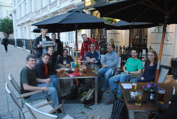
This pub meet-up was image of the week!

Quite a nice happy photo, although we actually had more people turning up a bit later, and more sunshine a little earlier. I think we can try for a better photo (maybe tonight??) Anyway... sitting outside the pub there, we talked about....

See full entry

Location: Tachbrook Estate, Millbank, London, Greater London, England, SW1V 3RN, United Kingdom

London Hack Weekend and OpenTech

Posted by Harry Wood on 23 May 2011 in English. Last updated on 1 June 2011.

It's been a pretty intense period of OpenStreetMappy stuff. There's a few things I need to catch up on, here on the diary.

2011-05-22 (0010)

The London Hack Weekend May 2011 has just been and gone. Here's some things we hacked upon:


  • User:Matt fixed some evil infinite looping bug which was showing up intermittently as rails processed diff uploads. This involved some in-depth diagnostics and then code changes to allow an upgrade to libxml. Looking good so far. The problem may be fixed.
  • User:TomH worked on reviewing a lot of work by User:Amm.
    • The code branch formerly known as "OpenStreetBugs" is now called "notes" (a less geeky name for reporting bugsnotes on the map) Not quite deployed yet, but getting there
    • The OpenID work is also under review (allowing people to create an account authenticated by some other provider instead of setting up a new account on OpenStreetMap.org)

See full entry

In this old diary entry I mentioned several neat things, including QualityStreetMap version 2, which is all about presenting mappers with an assessment of completion levels. There's something quite neat about the idea of binding things to an endless globe-spanning grid, and following the Tile naming conventions used everywhere with tile image rendering seems like a smart idea too. But grids have their disadvantages...

When dealing with on-the-ground details, and thinking about splitting up an area for a mapping party, a grid just doesn't cut it. I remember we discussed the idea back in the early days, but no... I went to some detail on the artistic progression of cake diagrams in my State of the map 2010 talk. The cake diagram is an irregular oddly shaped higgledy piggledy sort of thing, and that's the way it has to be. In fact it's become more oddly shaped over time as we try to accommodate uneven distributions of POI gathering effort. Designing cake diagrams is sort of a fun part of running a mapping party, but we've pondered other ways of doing it. Matt and I in particular, came up with ideas for interfaces involving javascript clickability. Never got around to building anything though. But now... drum-roll please...

MapCraft!

See full entry

The Marylebone meet-up

Posted by Harry Wood on 3 May 2011 in English.

Last Wednesday we had the first of the London summer mapping parties. Technically it was the second in the series but this time we actually did some mapping for at least some of the evening.

We were mapping Marylebone / Bond Street area (cake diagram), which is the North Westerly boundary of the big London building blob. I was hoping to extend this a little, plus the whole area is bristling with POIs. Some mapped. Some not.

I met with Kevin to give him a mapping demonstration, and as we walked around slice 7 we found that Great Portland Street was already well mapped, but Regent Street had plenty missing. I find myself keeping a keen eye out for cycle parking these days. I think Islington council have been adding a lot of new ones near where I live. We spotted a few unmapped ones around Cavendish Square too. We also happened across a shiny new burrito shop!

See full entry

Location: East Marylebone, Fitzrovia, Camden Town, City of Westminster, Greater London, England, W1T 3PP, United Kingdom

Blue Posts meet-up last week

Posted by Harry Wood on 16 April 2011 in English. Last updated on 18 April 2011.

Over on this talk page I've explained the predicament I'm in. It's no different from the end of last summer, but now we're at the beginning of a new mapping season. Where to go mapping? This and shortage of time meant I failed to prepare any cake diagram for Wednesday's london summer mapping party

As usual we kind of failed to make any solid plans in the pub, we did have some discussion of the topic. Derick was suggesting we should gather missing tube entrances (railway=subway_entrance nodes). I suggested these tasks (stations where there are none) could be added as openstreetbugs. There's lots of mapping to do based on fixing of London OpenStreetBugs, geofabrik fixmes, and keepright bugs, but somehow these tools don't seem to have a good enough throughput of useful bugs to make them very worthwhile. I think particularly in the case of the human reported OpenStreetBugs, if we could get input from more non-mapping new users, we might start to see more of an interesting turn-around of new bugs getting reported then fixed. Not entirely sure what they're missing, but they're missing something. They're like a communication channel which hasn't gained critical mass yet.

See full entry

Location: East Marylebone, Fitzrovia, Camden Town, City of Westminster, Greater London, England, W1T 3PP, United Kingdom

We rounded off the London winter mapping meet-ups with a trip back to the Monkey Puzzle in Paddington. I forgot to take any photos! Too many interesting conversations going on:

Simon Nutall, one of the CycleStreets developers, was visiting from Cambridge. Naturally we got talking about routing. With it's triple route response (quiet, fast and balanced route), cyclestreets is a sophisticated OpenStreetMap based routing system, but I was surprised to learn that it doesn't heed turn restriction relations. These don't actually occur all that often, and it always seemed doubtful to me that they are desperately important to capture for routing. This confirms it. Note that most instances of what you might call a "turn restriction" are mapped more simply, as one-way streets, without the use of relations. It's good that we have a mechanism for mapping the more complex restrictions, but it's not an essential part of mapping.

Having said that, Simon told a rather alarming story of how he once received a fine from the council for performing an illegal turn on a bike! They posted him evidence captured on camera. todo: link to his blog post about it?

We also had livingwithdragonsMarlerTheGregmeisterGregory in attendance. Down from Durham on business. He has a geojob! Congratulations to him on that.

Richie from Sabre was there. We chatted about amusing sign post screw ups. This one in Wales is my personal favourite.

JennyH was there. She's just left her job at nokia. A lot of people are quitting nokia's burning platform these days it would seem. So she'll be on the look-out for new opportunities I guess. She said she's joined the London hackspace, so we can watch out for her on the webcams.

Derick is moving house. This is good news. He's created his own building blob in North West London. If all of our pro mappers would just move house more often, we'd have the world mapped in no time!

See full entry

Location: Paddington, London, Greater London, England, W2 1HH, United Kingdom

I missed the last OSMLondon meet-up. Wynndale stepped in to organise, and bravely opted for an out-of-centre location, Fulham, one of the winners of the London Streets Challenge. So no diary entry (unless someone else wants to write one??) but there's photos on flickr

Obviously missing an OSM London meet-up is distressing for me, but I was away getting sun burnt in Brazil, so can't complain. And in fact I got up to quite a lot of OpenStreetMappery while I was out there...

Compared with previous Brazil trips, I could now see and use the map I was contributing to, thanks to my android phone and the Mapdroyd app. This let me download the whole of Brazil in some sneaky binary vector format, taking up just 30 Mb on my SD card, and giving me offline fluid vector browsing for the whole holiday. Unfortunately the otherwise very nifty client vector rendering engine, seems to hit some problems with rivers, which meant the map of the old town of Recife looked a bit pants. I have since added centrelines to the rivers in addition to the waterway=riverbanks as per those instructions. I imagine this might help MapDroyd to at least show something. I've spotted other Brazilian rivers which are missing their centreline way.

Recife is a hot northern Brazilian city where we stayed for a week, by the beach. Here's me finally getting chance to read the openstreetmap book

See full entry

Location: Paraíso, Vila Mariana, São Paulo, Região Imediata de São Paulo, Região Metropolitana de São Paulo, Região Geográfica Intermediária de São Paulo, São Paulo, Southeast Region, 04002-021, Brazil

Mulberry Bush last month

Posted by Harry Wood on 22 March 2011 in English.

The last time I was at an OSM London meet-up was four weeks ago. Feels like a long time. We were in the Mulberry Bush, and I seem to remember it was a good gathering.

mulberry bush panorama

Yep. Lots of people around the table. I have some notes. Some interesting conversations as ever, so, even if this is a bit out of date, here's what we talked about:

This meet-up took place the day after the Christchurch earthquake. TomH was, at the time, on holiday in New Zealand, and for few hours there had been concern that our chief sysadmin and rails developer might have been earthquaked upon. But no. Firefishy saw activity from him on the server a few hours later :-) Since then there was some crisis response mapping efforts coordinated on the Christchurch earthquake wiki page (And of course various other disasters have occurred since then. See my HOT blog post)

See full entry

Location: South Bank, Waterloo, London Borough of Lambeth, London, Greater London, England, SE1 9PX, United Kingdom

The Euston Tap meet-up

Posted by Harry Wood on 21 February 2011 in English.

The next London pub meet-up will be at the Mulberry Bush this Wednesday! Sign up! Sign up!

Last time we went to a new pub called the Euston Tap (eustontap.com). When Ollie linked to this pub suggestion, I couldn't quite believe the location, and as I approached on my bike, I still couldn't believe it. There's only one "building" out the front of Euston station. well actually a pair. either side of the entrance road, they're decorative stone gatehouse type things. And they've managed to squeeze a new pub into one of those! We sampled the interesting ale selections from the ground-floor bar, but headed up a tall spiral staircase to get a table in the windowless upstairs room. All a bit odd, but in an interesting kind of way.

outside the Euston Tap

See full entry

Location: East Marylebone, Fitzrovia, Camden Town, City of Westminster, Greater London, England, W1T 3PP, United Kingdom

London meetup: Logos, Missing Streets, Imagery offsets, XAPI etc

Posted by Harry Wood on 29 January 2011 in English. Last updated on 3 February 2011.

We were at the Blue Posts again on Thursday night (London OSM meet-up)

Alex was there. Congratulations to him on getting accepted for a PHD in London. We'll be seeing more of him! Hopefully he can work in some OpenStreetMap into his PHD topic too.

Matt (who sometimes goes under the pseudonym of a Japanese cartoon porn star) was there. We discussed how he is now considerably less evil. Although his new employer polluted the world with many unnecessary CDs in the late nineties, at least they didn't... lets just leave it. Don't want the big T coming after me. Anyway, congratulations to him on starting at (AOL) Mapquest. I hope they'll put him onto creating more OpenStreetMaptastic stuff.

Matt is the creator of the OpenStreetMap logo. We got onto talking about logos, and asked him if the pattern of 1s and 0s in the design encodes a hidden message. He neither confirmed nor denied it. On the topic of the the new HOT logo Andy pointed out that it could be confused for a "warning this is hot" symbol. Good point. Guess this means we should try to use the version with text alongside whenever possible. In any case, it's pretty nice design. Time to turn our logo designing attention to the SOTM logo design challenge!

See full entry

Location: East Marylebone, Fitzrovia, Camden Town, City of Westminster, Greater London, England, W1T 3PP, United Kingdom

Last week I was away in Switzerland on a working slash snowboarding trip, which was a pretty exhausting combination!

Part of the (placr) work I was doing, between daydreaming about the snowboarding I'd been doing each morning, was getting set up to do android development. In future my work may even involve maps on android (will look into Osmdroid I guess) but initially I was struggling with various more basic things.

As for the morning snowboarding, I thought I'd leave the GPS shenanigans till later in the week, but that was mistake. The weather got colder (seriously cold!) making it very difficult to take gadgets out of pockets, and also killing their batteries. Even so, I was able to make a few additions and corrections to the OpenPisteMap of Scuol (when will it re-render though?).

mmmmmmm piste.

Scuol

See full entry

Location: Salez, Scuol, Region Engiadina Bassa/Val Müstair, Grisons, 7550, Switzerland

Last Thursday's Daniel Gooch meet-up

Posted by Harry Wood on 9 January 2011 in English.

The 2011 London OpenStreetMap meet-ups kicked off with a bang last Thursday. Actually that's not entirely true. It was a pretty quiet one, with just a few of the usual faces, making for a nice friendly chat down in the little cubby-hole at the back of the Daniel Gooch. Both the scots were in attendance, but we were all disappointed when it turned out the kitchen wasn't open. The promised little scottish pies were nowhere to be seen! The natural fallback plan was curry at node:511172059. I've been to Khan's several times five or six years back, but these days they don't serve alcohol, so it was mango lassies all round.

See full entry

Location: Westbourne Green, Bayswater, London, Greater London, England, W2 5EA, United Kingdom

I spent new year up in Edinburgh. The Hogmanay was quite good, but personally I was more impressed by the loony dook. This all took my mind off work... sometimes.

We did quite a bit of travelling by bus, and being entirely unfamiliar with the bus routes, various aspects of this were quite a struggle in an interesting geo kind of way. At placr I've spent some time untangling London bus schedule XML structures. Here's a sneak preview of some output bus timetables. It feels like quite an achievement to actually manage to produce timetables from these files, but I've got some more work to do to output them in more query-able dynamic ways and useful formats. So anyway, some information like that might've been useful while travelling around Edinburgh (we only have London data at the moment)

Mostly though I found myself wanting maps. Why do bus stops often not have maps? I always imagined this might be because transport companies have to pay for costly licenses to display maps to the public. I'm not sure if that is the reason, but if it is, I've got a little hint for these people: OpenStreetMap.org. ...you should check it out.

I pondered these things while sitting waiting for buses in the cold. I also fiddled with my android phone, and pondered ways in which this low-bandwidth fat-fingered browser-incompatible experience sucked. What I really needed on various occasions, was the öpnvkarte.de view of Edinburgh. In a mobile browser I was stuck fingering a non-draggable OpenLayers view of German buses. I hoped it might be available as a layer in some other app, but didn't find it (anyone know?) This gave me some ideas for building simple mobile map interfaces. For example, in this situation a static image view of Edinburgh bus routes would've been enough. I was also trying to remember an old tweet from @chrisfl. Looks like "bustracker" would've been super-useful (although using inferior maps for some reason)

See full entry

OSM Christmas Party London

Posted by Harry Wood on 20 December 2010 in English.

We had our OpenStreetMap Christmas Party in the Blue Posts pub near Oxford Street. It turns out that after work on a Christmas shopping Friday, this pub is rather busy. Even in the sneakily hidden upstairs area, we weren't going to get a table any time soon. And there was quite a few of us there, all celebrating OpenStreetMappy Christmas, plus a few other friends of mine in the pub at same time too.

See full entry

Location: East Marylebone, Fitzrovia, Camden Town, City of Westminster, Greater London, England, W1T 3PP, United Kingdom

Map Art

Posted by Harry Wood on 15 December 2010 in English. Last updated on 22 December 2012.

On Friday it's the OpenStreetMap Christmas party, taking place at various wordwide OSM party points: Toronto, Bremen, Grenoble, Belo Horizonte, and of course London. Although it may look like a normal pub meet-up, the idea is to make this a big one, full of Mappy Christmas cheer! It's on a Friday, so hopefully people will make the journey from a little further afield than usual.


I just had to bring out the holly bells picture again. I'm super proud of it. It took me a good few hours to create this image. Obviously I agonised over the artistic aspects of it, such as highway=secondary versus highway=tertiary for the bell stripes, but the real reason it took so long is because I was getting up and running with the dreaded Mapnik. My approach to this kind of thing tends to involve making every mistake in the book before hitting upon a vaguely working installation. Here's how not to do it:

See full entry