OpenStreetMap logo OpenStreetMap

Harry Wood's Diary

Recent diary entries

It's been a while since we had a common conventional good old straightforward London pub meet-up, mainly because there's been all sorts of other awesomeness going on.

A bunch of OSMLondoners headed off to Brighton to do a big mapping session. Some new patches of buildings appearing there as a result, and lots of POIs. Here's some photos. Looks like fun. I'm not the best person to report on that, because I wasn't there...

Instead I went to the headquarters of MapAction, and joined in with one of their training weekends. I have lots to report back on from that, and thoughts on how MapAction and HOT should relate, so full blog post coming soon on that. Photos of tents etc to keep you going in the meantime.

Last week we had a #geomob meet-up. My photos also with descriptions and links. I hadn't realised beforehand, but Steven Feldman was presenting his OSMGB project there.

Last but certainly not least, we had a London Hack Weekend last weekend, which was a pretty big event.

See full entry

Upcoming events + Monkey Puzzle last time

Posted by Harry Wood on 18 November 2011 in English. Last updated on 30 November 2011.

There's a handful of interesting events coming up in and around London, in and around OpenStreetMap:

Saturday tomorrow there's a Brighton mapping party if you fancy a short journey out of London. The cake diagram is looking quite epic! I'll be missing this Brighton action, which I'm quite sad about. Instead I'm going camping (brrr)

Next Thursday 24th Nov - #geomob! The quarterly presentations evening on geo topics. This time the guy behind the BusMapper app, which consumes placr transport data, will be presenting. So not directly OpenStreetMap related, but a bunch of OSMers will be there.

Then on Sat 26th / Sun 27th Nov we have the OpenStreetMap Hack Weekend. Looking forward to this one. It's a chance to discuss and hack with the developers working on core components of OpenStreetMap, or just with pet projects and applications using OSM. Come along to join in the fun! By the way I've just experimented with setting this up on lanyrd, so if you're a twitter user (and who isn't??) be sure to "attend" or at least "track" the event on there.

I didn't manage to squeeze in another winter pub meet-up between all these things. I'll probably wait till the week after. But how did the first one go? Well I'll tell you...

In the monkey puzzle, we huddle around and lamented the lack of mapping fun. But we got over it pretty quickly :-) And we talked about...

Transport ticket prices. Always a good conversation to kick things off.

We had Shaun there, and he was back from google HQ where he'd been at the Google Summer of Code Documentation Summit. He and Kate Chapman, Ian Dees, Anne Gentle, Nóirín Plunkett, Tomi Toivio, and Anne Goldenberg had all been working on a new OpenStreetMap book, a copy of which he had with him:

See full entry

Location: Paddington, London, Greater London, England, W2 6QS, United Kingdom

Pontefract Castle meet-up + next one now!

Posted by Harry Wood on 8 November 2011 in English. Last updated on 14 November 2011.

A couple of weeks ago we had our last EVER London Summer 2011 mapping party.

I suggested a pub meeting time of 7p.m. and just half an hour of mapping, but I usually start mapping about half an hour late, so it wasn't much of a mapping session for me. I did spend a few minutes trying to check some little details as I approached the pub on my bike, but mostly the building outlines I sketched in from Bing remain unchecked for this one. One thing I tried to check was this building which doesn't correspond well with bing. I was looking from Queen Ann's Street, but couldn't see what that was, so maybe its supposed to be on the Portland Place street front.

The expansion of building coverage has hit a sticking point at Marylebone and Mayfair. Setting cake diagrams repeatedly on the same areas doesn't seem to be helping! I suppose this is because they are not very interesting areas to map in. Given the new flurries of building coverage around Paddington, Bayswater, and South Kensington, it would be a shame not to get these bits filled in, but maybe it'll have to wait for next summer. The nights are too dark for mapping now.

In the Pontefract Castle pub we took a while to get a table this time. We met Ryan who works for British Waterways. He was describing some map data he has, and hopes to open up. He was also saying he set some work placement students a programming challenge to create a game involving OpenStreetMap and OpenLayers vectors. I forget the details but it sounded like fun.

See full entry

Location: East Marylebone, Fitzrovia, Camden Town, City of Westminster, Greater London, England, W1T 3PP, United Kingdom

Betjamen Arms, the minutes

Posted by Harry Wood on 8 November 2011 in English. Last updated on 10 November 2011.

I already wrote a diary entry about the Betjamen Arms meet-up but I found a scrap of paper with some minutes (notes from the pub) So in the interests of documenting these things fully: We talked about...

The UCL mapping party, wheelchair mapping, and wheelmap.org. I think it was Derick telling us how that had gone. But I see there's also a nice blog write up from Patrick Weber, including photos of sunshine (Not fair! When I went mapping with UCL students, we had to do it in the rain!). I hadn't realised Andy Allan managed to get along to the second day, and make some more valuable notes on things which confuse beginners. Great stuff.

Andy Allan was also at the pub, and he described a rendering problem which cropped up on OpenCycleMap.org . A large area of Germany showed up blue like a river because of some strange osm2pgsql relation handling, and some kind of confuddlement to do with falling back to the first tag it can find, which this time happened to be waterway=stream. I forget the details, but it sounded quite bizarre.

We talked about Ruby on Rails versioning, and about how rvm (ruby version manager) is a good thing to use. Install it first and then install passenger when setting up new rails servers. ...is the advice I still need to get around to following myself.

And we talked about the shortlink algorithm. Derick was annoyed because twitter made a mess of the '@' character in it's URL handling, and this is one of the 64 characters used (See the array defined in the code) Of course any alternative character you might choose can also be problematic. We decided maybe '~' would be better than '@' ...but mostly it's twitter's fault.

Oh and Shaun had a tripod with him. So I was able to do some very professional looking photography:

See full entry

Location: Pentonville, Barnsbury, London Borough of Islington, London, Greater London, England, N1 9JE, United Kingdom

Betjamen Arms previously + Marylebone TONIGHT

Posted by Harry Wood on 25 October 2011 in English. Last updated on 8 November 2011.

A couple of weeks ago we had our London meet-up in St Pancras at the Betjemen Arms. I wasn't sure what to expect. It could've been a grotty train station pub, but it turns out to be more of a posh hotel bar because it's under / part of the newly re-opened posh hotel in the ornate red brick front of St Pancras station. If you look at the awesome lego background on their website you'll probably recognise the location.

I had hatched a plan to have a joint pub meet-up with the folks from OpenSpending.org, but in the end we decided it was best to keep separate. This wasn't difficult since we'd grabbed a table outside on the terrace. I had intended to say "hi" to them at least, but didn't even do that in the end. It's all too easy to sit around and chat about nothing but OpenStreetMap to nobody except openstreetmap enthusiasts.

See full entry

Location: Pentonville, Barnsbury, London Borough of Islington, London, Greater London, England, N1 9JE, United Kingdom

baseball. 58 people so far

Posted by Harry Wood on 13 October 2011 in English.

Last night I kicked off the Big baseball project 2011

baseball

I developed a deep love for the game of baseball when I went to see a Rockies game in Denver with my OpenStreetMap friends at the State Of The Map conference.

OK that's a lie. I sat looking confused like all the other European OpenStreetMappers there. In fact we were all quite hilariously confused, especially when the whole crowd spontaneously stood up and sang some kind of exercise routine song. But it was great fun, and I realised I was going to have to set up a Baseball edit tracker and user rankings

This is using the same code as the previous edit tracker of tennis edits during wimbledon, so was fairly quick to get set up. We also have (and this is really awesome) a tutorial video made especially for the big baseball project:

How to add a baseball diamond by Ian Dees.

and also...

A baseball data map from ITOworld.

See full entry

We have another London Mapping Party TONIGHT!

We had one a couple of weeks ago too, in Stratford. Who else remembers the Stratford Mapping Party in 2008? This was back in the days of epic street name gathering, but we did also do a bit of POI gathering, and I remember a big shopping mall near the station. But this same shopping mall is now looking a bit sad and pathetic under the shadow of the mondo-ginormous retail behemoth: Westfield Stratford City. This opened on the 13th, so we were there to map it the week after! (Thanks to Ollie for suggesting it)

This was fresh mapping without the aid of bing imagery (all new buildings). Sadly it wasn't really an opportunity to play with GPS gadgets since most of the details to be gathered were indoors.

I had a bit of an anxiety moment walking into the shopping mall, until I remembered my girlfriend wasn't with me. "It's OK we don't have to spend hours here. Just a quick bit mapping and then get the hell out!" I told myself. Although admittedly I did go inside one shop... LEGO!

See full entry

Location: Stratford New Town, Maryland, London Borough of Newham, London, Greater London, England, E15 1JQ, United Kingdom

Hyde Park Trees

Posted by Harry Wood on 28 September 2011 in English. Last updated on 21 May 2012.

Back in early 2010 somebody added a patch of woodland on the eastern end of Hyde Park, clearly representing an area of tree coverage they could see in yahoo imagery (way 52995836 if you're interested). They only mapped tree coverage at the very Eastern end of the park. To me this seemed a bit messy, in the same way that patchy building coverage seems messy. (It was also done initially with a silly tag, but that's another issue) Perhaps this is an example of excessive detail causing problems. One solution I was very tempted by, was to just delete it.

But, I thought, all it would take is for somebody to sit down for a hour and trace the rest of the trees in the same way, and we would have a consistent level of detail across Hyde park. Well today I'm just noticing that someone has done it! It took over a year, but someone's done it:

See full entry

Location: Paddington, London, Greater London, England, W2 1HH, United Kingdom

I'm receiving a geo-bombardment a the moment. I went to a three day Society of Cartographers conference in Plymouth followed immediately by the big one, State of the Map in Denver. I also crashed a party after the first day of the FOSS4G conference before I had to fly back from Denver. My geo-cup was overflowing, but then it was topped up a little more with #geomob back here in London. I've got as far as uploading photos from these things on my flickr, but I still need to fanny around with publishing slides (takes a long time if you're perfectionistical about it) and write some more blog posts about these things.

But never mind all that. The most important geo event of all is happening TONIGHT. The event which brings it all back to earth. The very bedrock of geo. The ultimate fusion of deadly serious geospatial expertise and social pub shenanigans. Yes that's right... Tonight we have...

...a London Mapping Party.

So we'll be doing the usual thing. I haven't been to a good old mapping & pub evening since July, so let's just remind ourselves what the usual thing is: Everyone is welcome. We sit around in the pub and chat about OpenStreetMap. There's some regulars, but we love to meet new people, OSM experts and beginners alike. If you've never edited OpenStreetMap, don't be shy. We'd love to meet you too (And we know from our stats that surprisingly some people the in world have not edited) Before going to the pub we try to go out and do some mapping in the area, but if that sounds complicated, ignore it. Generally this is a relatively minor part of the evening which many people skip altogether. However...

See full entry

Anniversary Party last weekend

Posted by Harry Wood on 26 August 2011 in English.

If you didn't already see them, check out the awesome OpenStreetMap anniversary party cake photos. A crisp looking OSM logo design at the FrOSCon in St. Augustin, Germany, and a psychedelic blue cake in Toronto (I think this is cloudmade style 6213 but not sure about the zoom level and projection) Hope everyone enjoyed their parties around the world as much as we did in London.

In London we had sunshine! It rained pretty heavily in the morning, so nobody quite believed my plans for a sitting outside in the sunshine, but you should've had more faith:

OpenStreetMap Birthday party

This photo is by Alex. There's some inferior (but also sunny) pictures by me here on flickr

After such an early start I think I got quite drunk, but can just about remember some of the conversations we had. We talked about...

See full entry

Location: Paddington, London, Greater London, England, W2 6QS, United Kingdom

bing and yahoo low-res imagery

Posted by Harry Wood on 18 August 2011 in English.

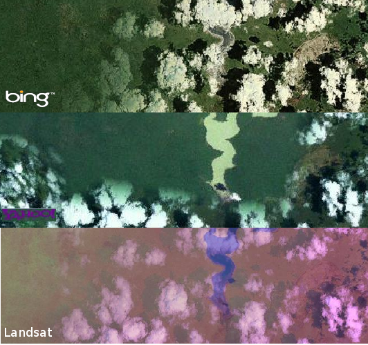
During the recent HOT chat, when we talked a bit about the aerial imagery in Somalia, I was giving my simplistic understanding about what bing and yahoo do through most of Africa, and any other parts of the globe where they haven't spent a bit extra on high resolution imagery. Basically they use landsat; the public domain satellite imagery from NASA. Landsat is certainly better than nothing, but limited in resolution such that towns are fuzzy blobs and you can't really see any roads (none but the largest motorways) Bing and Yahoo immediately look different from landsat because they apply their own colour enhancements, or perhaps correct the colour enhancements nasa applied. But they're all landsat right?

I thought I'd check this, and quickly realised that it wasn't the full story. I took a look at the southern end of this lake near Jilib. By the way, this lake is shown on OpenStreetMap but not google or yahoo maps, and inaccurate on bing. Win! But what about in the imagery...

See full entry

I grant the lolcat of awesomeness to Pascal Neis

Pascal has been cranking out an array of nifty little tools which make being an OSM contributor more fun: "How did you contribute?", "OSM fight", "Your OSM heatmap". All fairly simple, but quite nifty in the way they are presented. Also check out his disconnected villages map, and he is one of the brains behind the Open Source Routing Machine.

As well as being a prolific technical developer he's also a great communicator. His blog explains his creations, but also is stuffed full of fascinating analysis of OpenStreetMap growth. All of this is awesome enough to deserve recognition, but additionally Pascal is instrumental in creating the weekly OSM summaries. We also have Jonas & Dennis to thank for this. Since November these blog posts to opengeodata.org have given a round-up of OpenStreetMap news items which I personally find extremely useful, but I also think it's an important way to help newcomers get their heads around OpenStreetMap (I believe they're actually incubated in German as the "Wochennotiz" on blog.openstreetmap.de)

Keep up the awesomeness Pascal!

One more piece of awesomeness I didn't mention: When is your OpenStreetMap birthday? (explained here) Which he has created to commemorate...

The OpenStreetMap 7th Anniversary

See full entry

Angel mapping evening

Posted by Harry Wood on 9 July 2011 in English.

As I explained previously there's a small area of Islington around Pentonville Road and north of Clerkenwell, which is sort of sandwiched between Blumpsy's blob of mega building detail and the main central London building coverage, so we headed there for last week's London Mapping Party.

I was conscious that this should really be my territory. In fact I mapped a slice of the cake and also off-cake cake up Amwell Street, which is actually the route I cycle home every day. I was in two minds about this. Feeling guilty that I hadn't managed to map it fully before, perhaps I should've left it to map during my cycling commuting some other time, but... it would certainly annoy me if somebody else mapped it first! I have added one or two details week by week from my cycle to work, but I'd have to be more organised (and cycle considerably more slowly) to do it properly. So last week I was on my usual cycle route home, but this time taking photos of every shop and other such details.

This process really highlighted for me the crazy serendipitous psychological state of mind I enter into when I go mapping. Despite being a very familiar road, it's not until I scrutinise it for OpenStreetMap that I realise things like this:


  • On that road there's a remarkable number of stylish looking shops with seemingly no name. How do you run a business like that???

  • There's a shop (or perhaps an office) offering dog walking services.

  • There's a gap in the buildings with big three metre high construction hoardings, but then bushes growing over the top. The land must've been unused/available for some time. Surprising for central London.

  • And finally there was a massive ugly 60s building bristling with security fences and surveillance; a high security office or perhaps a prison or something, also with no clear name, but I noticed the facility (whatever it is) is operated by serco. Very mysterious.


I love

See full entry


For a while the OpenStreetMap wimbledon tournament developed into a tantalising doubles match. The rankings showed Jaume Figueras storming into the lead. With his relation mapping powerful topspin who could be surprised? But from nowhere he was joined by jgallegocuesta forming a powerful Spanish team. Facing them across the court my friend rjhale1971 with his powerfull Chattanooga backhand volley, was suddenly joined by Aude to form a U.S. team. They haven't managed to get back into this match yet, but with 6 hours remaining there's still everthing to play for.

But just when we thought England's tennis hopes were in tatters Gregory Williams put in a string of aces! We thought we were in for a Spanish vs U.S. final, but things just got mixed up again!

Nobody can be ruled out of this tournament just yet. In fact all the OpenStreetMap tennis court mappers are champions! Have you got your name on the edits list yet?

Wimbledon update

Posted by Harry Wood on 3 July 2011 in English.

It looks like the Spaniard is coming second in the Wimbledon tennis tournament of OpenStreetMap too. I've added a rankings display to tennis edit tracker

>>> Tennis edit rankings <<<

Jaume Figueras mapped loads of tennis courts today near Barcelona, but rjhale1971 served an ace, and it looks like he'll go on to win the tournament. Can anybody stop him?

I suppose we'll find out at the end of the week (Wed 6th) who the tennis court mapping champion is. See the Project of the week page for tips on how to find and add tennis courts.

Tennis court mapping

Posted by Harry Wood on 2 July 2011 in English. Last updated on 6 July 2011.

I created a Wimbledon "Tennis Edit Tracker":

I haven't had time to add more fun (e.g. show a leaderboard of who's doing most editing) But it is quite fun, just to see your edits showing up on there, and maybe I'll add features at the end of the week. It's project of the week to map tennis courts timed to coincide with Wimbledon. In fact an rather pleasantly relaxing way to spend an afternoon could be watching Wimbledon while sketching tennis courts into OpenStreetMap. That's what I'm doing right now!

Where to map tennis courts? Well I've added lots of information about this on the project page. Map your local ones first of course, but then try some in the U.S. Here's the game:

See full entry