OpenStreetMap 标志 OpenStreetMap

InfosReseaux的日记

最近的日记文章

Power infrastructure, climate change and OpenStreetMap

InfosReseaux 于 2025年一月19日 以 English 发布 最后一次更新于2025年一月27日。

OpenStreetMap is now 20 years old. Its community is contributing to complete a geographical database which fuel many activities, for instance useful for energy transition and power grids asset management. The increasing impacts of extreme weather phenomenons like storms or wild fires disrupt power grids and expose them to wider outages. Operators have to reinforce and adapt their assets for those upcoming challenges.

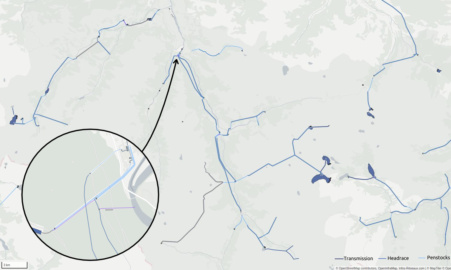
Overhead power grids asset management had suffered from disinterest since early 1990s for instance in France. It remains at least a significant challenge in developed countries. Important decisions that had been made to bury them and more generally because they are “highly visible infrastructure” don’t bring value to accurate knowledge about existing infrastructures. Nevertheless, several decades are required to completely hide a very capillary distribution grid. So we need to better describe them for sake of maintaining remaining overhead power grids, particularly ones that couldn’t be buried. In particular, very high voltage transmission lines will remain mainly overhead.

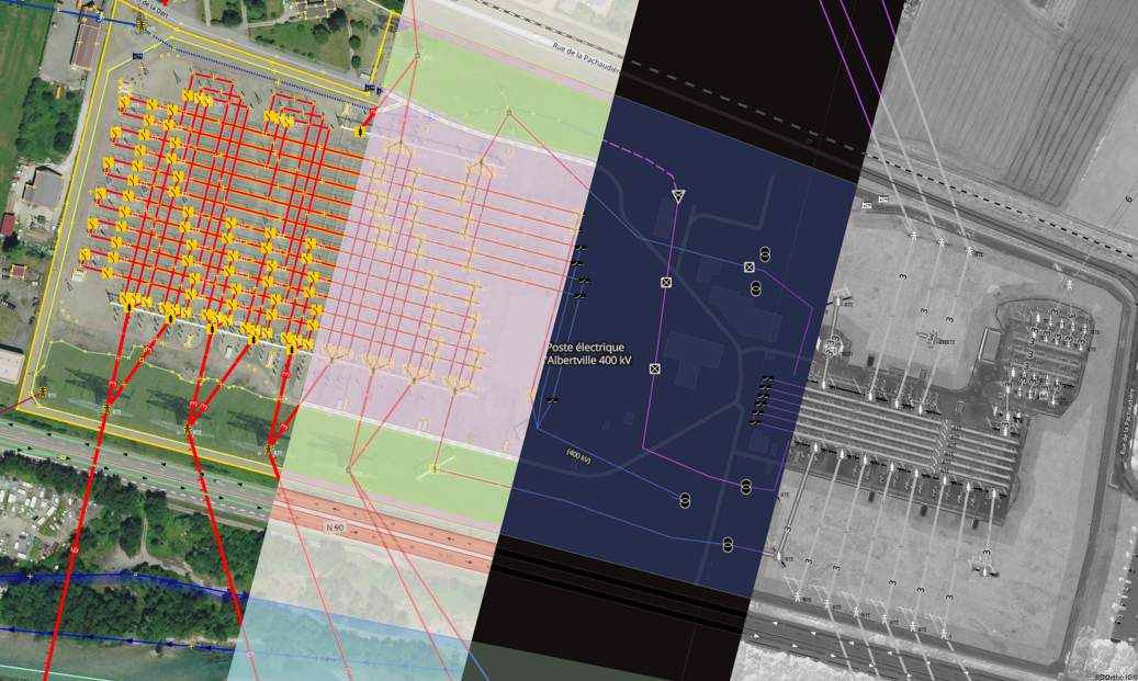
Producing and maintaining knowledge about utility networks assets is tedious and expensive without appropriate tools. I already had opportunity to explain how the “OpenStreetMap way” is helping for power transmission grid knowledge, back in 2020. Operators now face other challenges and are busy with bigger investments for transitions. Yet lesser time left for knowledge management as projects pace accelerate. Power grids inventory started early after OpenStreetMap birth in 2004. It began with most visible transmission grids. Tagging improvements are continuously made since 2010 and 15 years later we reach another step with a deeper experience in such activities.

查看完整日记文章

Generalize OSM tagging model awareness and usage

InfosReseaux 于 2023年六月22日 以 English 发布 最后一次更新于2023年七月 2日。

Hello everybody

OSM Tagging model is a unique piece of knowledge and its usage could be discussed more widely, even outside of OSM.
Recent announcement of Overture Maps Foundation data schema will challenge us shortly. I’ve been involved in tagging improvement for more than 10 years and I now believe a lot in its more general usefulness, even outside of OSM.
It’s time to find how making it obvious.

First of all, tagging is a core component of OSM project and will remain as this in the future, the point isn’t to split mapping and tagging appart.
However, our tagging model could inspire (or already inspires actually) many data managers operating data bases outside of OSM.
A lack of consistency, versatility and even relevancy are sometimes noted about many data sets we can be using in general. They are at least missing some uniformity while some of them describe the exact same objects despite coming from different producers.

The more we have data, the more we need to standardize their structures.
OSM actually have the advantage to be built over a single namespace and force contributors to maintain consistency between very different concepts. It’s not an usual practice, there isn’t so much databases that gather buildings, roads, trees and utility networks in the same place.
Time spent to document tagging is now a significant force to make our semantics usable even outside of OSM.
It’s not necessary to import private databases in OSM nor use OSM tools to get benefit from usage of provided tagging, if applicable.
Developing tagging is not necessary a call to mapping or an attempt to make a given contribution mandatory. It’s also an exercice which demonstrates every day the versatility of OSM semantics and creativity of involved contributors.

In France, we already began to build strategic bridges between OSM tagging and business standards or government standards in order to make things interoperable.

查看完整日记文章

OpenStreetMap for hydropower

InfosReseaux 于 2022年十二月23日 以 English 发布

Hydropower mapping and render in French Pyrénées mountains

Water management and power infrastructure had made me busy here for years. Hydropower infrastructure intersects them both.

A new wikipage has been published about that (and waits to be improved) : osm.wiki/Power_generation/Hydropower

It’s not only about dams, power houses but about waterways as well, and OSM tagging model has been continuously developing to describe this. Water management will be more and more important in coming years to tackle droughts and fair water access challenges. Constantly seeking new ways to produce power and store water require accurate data and objectivity.

As hydro mapping and tagging improves on every continent, a more robust documentation on that particular topic may now be useful.

You will probably read it as a complement of existing waterways and water management pages.

查看完整日记文章

Starting January 2021, Enedis and OpenStreetMap France, OSMF French local chapter, entered together into a 3 years term partnership. It’s a significant step forward for data exchange and collaboration between OpenStreetMap community and utilities companies. Enedis started to publish some of its data under an open data Licence back in 2015 and now wished to ally to a well-known project like OSM to encourage crowdsourcing in a virtuous way.

Enedis operates the public electricity distribution network of 95% of Metropolitan France. It was the first European distribution system operator to get involved in open data by sharing useful assets for environmental transition and public service. Sharing its network cartography is particularly useful for OSM community since 2018.

This partnership is part of Enedis 2020-2025 Industrial strategy and as well in OSM France strategic roadmap to improve OSM usage and institutional contribution.

Partnership as a win-win solution

According to this partnership terms and conditions, Enedis agreed to provide more open data related to its operated infrastructure and aerial imagery at 5-cm resolution scale produced on a part of Metropolitan France over surroundings of power distribution grid. These pieces of imagery will be dedicated to OSM contribution only and will be usable as background in most of existing editors (JOSM, iD, …). This will serve common business topics shared by both Enedis and OSM France such as * Overhead power poles and lines mapping * Comprehensive surface power street cabinets inventory * Up to 4 other topics could be defined during this 3-years term.

查看完整日记文章

位置: La Pêcherie, Bouquetraud, Franchesse, Moulins, Allier, Auvergne-Rhône-Alpes, Metropolitan France, 03160, France

Pumps tagging proposal

InfosReseaux 于 2020年十一月22日 以 English 发布

Pumps cartography is useful in many ways in OSM and currently practiced around water wells. It’s possible to use the pump=* key to state for a pump availability on a given well only. The key actually refers to the pump drivers, a motor or a lever to manually move the pump.
It’s an important information as to know if you’ll be able to get water with or without physical effort.
For instance, it’s not yet possible to make a significant distinction between pumps running on electricity or gasoline engines among other possibilities.

Pumps are obvious but complex devices. Wikipedia already provides a comprehensive classification with up to 15 different kinds.

Each design have different capabilities and can be driven by numerous different drivers. OSM could get benefits from encouraging mappers to complete such detailed information with appropriate tags if they are knowledgeable to do so.
It’s clear that such information will help crisis management or emergency rescue teams to restore water supply if and only if they have appropriate generators or engines. Coming around a gasoline powered pump with a solar panel won’t help.
People themselves could be interested in case they have to bring their own material to get water.

查看完整日记文章

Power network digital twin Following a published article months ago, French OpenStreetMap community reached a step in the beginning of 2020 regarding cartography of highest voltage levels, 400kV and 225kV, power networks.

Contributors had been busy, providing valuable and detailed data for years since 2008 in many places in France. This now enables to assemble this knowledge to provide an elaborated digital twin of French power transmission network including routing capacities to get paths followed by electricity over networks. It is hard to reflect years along people engagement in a single article, but all of this has been a singular human collaboration for which we should be thankful.

查看完整日记文章

Improving power tower/poles mapping without tower:type

InfosReseaux 于 2019年十月26日 以 English 发布 最后一次更新于2020年一月 9日。

Power lines mapping has been a common practice for years and their supports can be used as landmarks in the country. There is undergoing work to improve the way we describe lines supports, including towers, not only for power but for telecom or other utilities as well. This diary will help to understand how is it going.

Currently, power functions find corresponding values in tower:type key. Main tower:type key use case is certainly to define the shape or the purpose of a tall and thin building.

As :type suffix may not be desirable since it doesn’t bring any extra information, I’m currently contributing as to cleanup this key in the power lines context and encourage the use of more meaningful terminology to make the same information more accessible, known as line attachments and management.

These concepts aren’t restricted to power towers and would have been redefined on other kind of power supports if nothing hadn’t been done in past months to cover the need to give more and more consistent information about infrastructure.

查看完整日记文章

Power substation Infrastructure cartography is the main topic I’m involved in in OpenStreetMap and certainly one of many good reasons of why such a free project is valuable nowadays. It’s really useful to get such data as a professional, to work for many network rollout or operation company. It’s also important as a citizen, to get a better understanding of how a city or our own district actually breathe or get fed by its different man made supplies. Everyone is able to more and more use OSM to get many other data than the road network which was the main initial proposal of the whole project.

I’ve been contributing to OSM for seven years now, both on the field to edit the map in the places I went and for the tagging model also. The last is literally the key to empower people to collect relevant information from any sources. I feel the need to sum up here rich discussions, interesting collaborations and the challenge the community achieve right now.

How OSM helps in infrastructure knowledge?

查看完整日记文章

位置: Vigy, Metz, Moselle, Grand Est, Metropolitan France, 57640, France