Kerploonk님의 의견
| 바뀜집합 | 날짜 | 의견 |
|---|---|---|
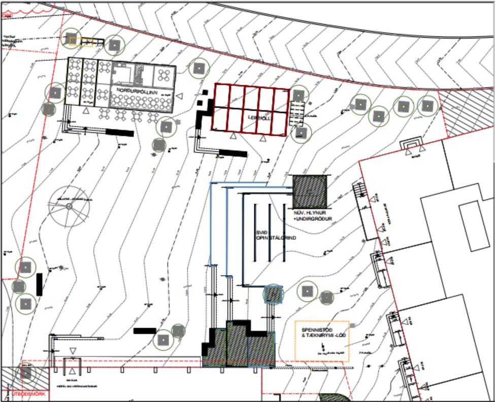
| 164001033 | 4개월 전 | Hi. They will be moving an existing historical building, Norðurpóll, to Hlemmtorg as part of the 5th phase of construction. The other building, Laugavegur 111, will house a playground "Hlemmur Leikhöll". Unsure whether it's an actual building, but it has an address. A part of Hlemmtorg after construction of the 5th phase can be seen here:
|
| 163173565 | 4개월 전 | Hi MissMarcoPolo, The updated ref tagging is based on Vegaskrá 2024, a public document in Icelandic published by the Icelandic Highway Administration (Vegagerðin), available for download from https://www.vegagerdin.is/samgongukerfid/vegakerfid/vegir .
The document is quite heavy and local knowledge is often needed to decipher the alignment of the roads. The data from Vegaskrá is also published as a GIS feature by LMÍ (National Land Survey of Iceland) under the IS 50 V set of GeoPackages for features in Iceland ( https://gatt.natt.is/geonetwork/srv/eng/catalog.search#/metadata/41D3314D-55AF-4FE3-9A9F-B9CB18AC5CAA ).
Cheers. |
| 158713069 | 9개월 전 | Svo voru nokkrar aðrar breytingar sem ég þorði sjálfur ekki að setja í gegn, t.d. 40 km/klst hámarkshraði á Hvaleyrarvatnsvegi, sem skv. listanum ætti að hafa 50 km/klst hámarkshraða en skv. götumyndum á ja.is og fyrri "töggum" er skiltaður með 30 km/klst hámarkshraða. |
| 158713069 | 9개월 전 | Var búinn að fara sjálfur í gegnum listann hjá Hafnarfjarðarbæ (https://hafnarfjordur.is/umferdarhradi-laekkadur-i-hafnarfirdi/)
|
| 156844141 | 11개월 전 | Changed on a legal level "city wide" that is to say |
| 156844141 | 11개월 전 | The street level imagery on ja.is is from summer 2022. In an announcement from Kópavogsbær March 2024 speed limits were reduced on almost all streets in Kópavogur. https://www.kopavogur.is/is/frettir-tilkynningar/breytingar-a-hamarkshrada
|
| 153472575 | 약 1년 전 | The Icelandic Highway Authority (Vegagerðin) classifies all its roads into different hierarchical groups;
The road classifications can be found in Vegaskrá, which is a public document and can be used according to osm.wiki/Iceland .
I don't really know why designation is used. According to osm.wiki/Is:Map_Features , the tag "network" should be used to indicate the road classification. I have simply been following convention seen on other roads. |
| 152057006 | 약 1년 전 | I'm fairly sure these restrictions do no apply to Akrafjallsvegur itself. Looking at the signs near the intersection of Akrafjallsvegur and Akranesvegur (https://ja.is/kort/?x=353234&y=428738&nz=13.52&ja360=1&jh=116.7) they all have a sign below stating an exception to the upper sign e.g. "No horses (upper sign) - í Hvalfjarðargöngum (lower sign)", meaning that the restriction only applies in the Hvalfjörður tunnel. |
| 151118501 | 1년 이상 전 | The name of this road is also Kambavegur on older plans, see deiliskipulag from 2007 below. While it is called Turnahvarf on the street sign, I decided to change the name in line with construction of a residential neighbourhood SE of Turnahvarf.
|
| 151118501 | 1년 이상 전 | I recently merged both segments in line with deiliskipulag (local plan) from 2023, see:
|
| 149633074 | 1년 이상 전 | *Ölkelduvegur |
| 147903812 | 1년 이상 전 | *147899600 |
| 145919036 | 1년 이상 전 | I was debating whether it should count as regional or local. I went with local since it's only on the agenda at Akureyrarbær, as opposed to the system in the capital (signed by most if not all municipalities there). |
| 145334841 | 1년 이상 전 | Source: https://straeto.is/skipuleggja-ferd/timatoflur/landsbyggdin |
| 144188671 | 1년 이상 전 | *Álftanes |
| 144150470 | 1년 이상 전 | Source: https://www.utu.is/wp-content/uploads/2023/07/8b.-Sunnuhlid_endursk.dsk_.-uppdr.pdf |
| 142095078 | 근 2년 전 | Unsure whether the road has been opened to the public but it's been paved recently. |
| 142065709 | 근 2년 전 | Second source, https://fundur.reykjavik.is/sites/default/files/agenda-items/Tillaga%20Einstefna%20Bjarkarg%C3%B6tu%20og%20Tjarnarg%C3%B6tu.pdf |
| 141066285 | 근 2년 전 | Here is the full report available to the public,
|
| 141066285 | 근 2년 전 | The boundary for the residential development extends between Einarsnes, Hangar 3, and Fáfnisnes.
Building no. 11 in the plan, south of Fáfnisnes, is a planned school building, not a house. |