OpenStreetMap-ан логотип OpenStreetMap

Декъашхочун тептар M!dgard

Дукха хан йоцу дӀайаздарш

The WW1 Western Front demarcation stones

Арахецна M!dgard 1 January 2025, мотт: English ТӀаьххьара карладаккхар 2 January 2025.

Earlier today I OSM-stumbled upon a stele marking the western front line of the First World War in Belgium and France. In Dutch we apparently call them demarcatiepalen, a term which I find amusingly technical sounding. In French they’re often called les bornes Vauthier, named after the veteran who took the initiative of erecting them. Carved from pink granite, they stand about a metre tall. There’s a whole line of them, but I noticed that they could use a lot of work, so that became my project for this evening.

A roadside memorial, a somewhat conal block carved from pink granite and about a metre high. The top of the memorial is shaped like a helmet. The engraving reads "Here the invader was brought to a standstill" but in Dutch. The memorial is set in green grass at a roadside, between a small brick wall and a hedge.

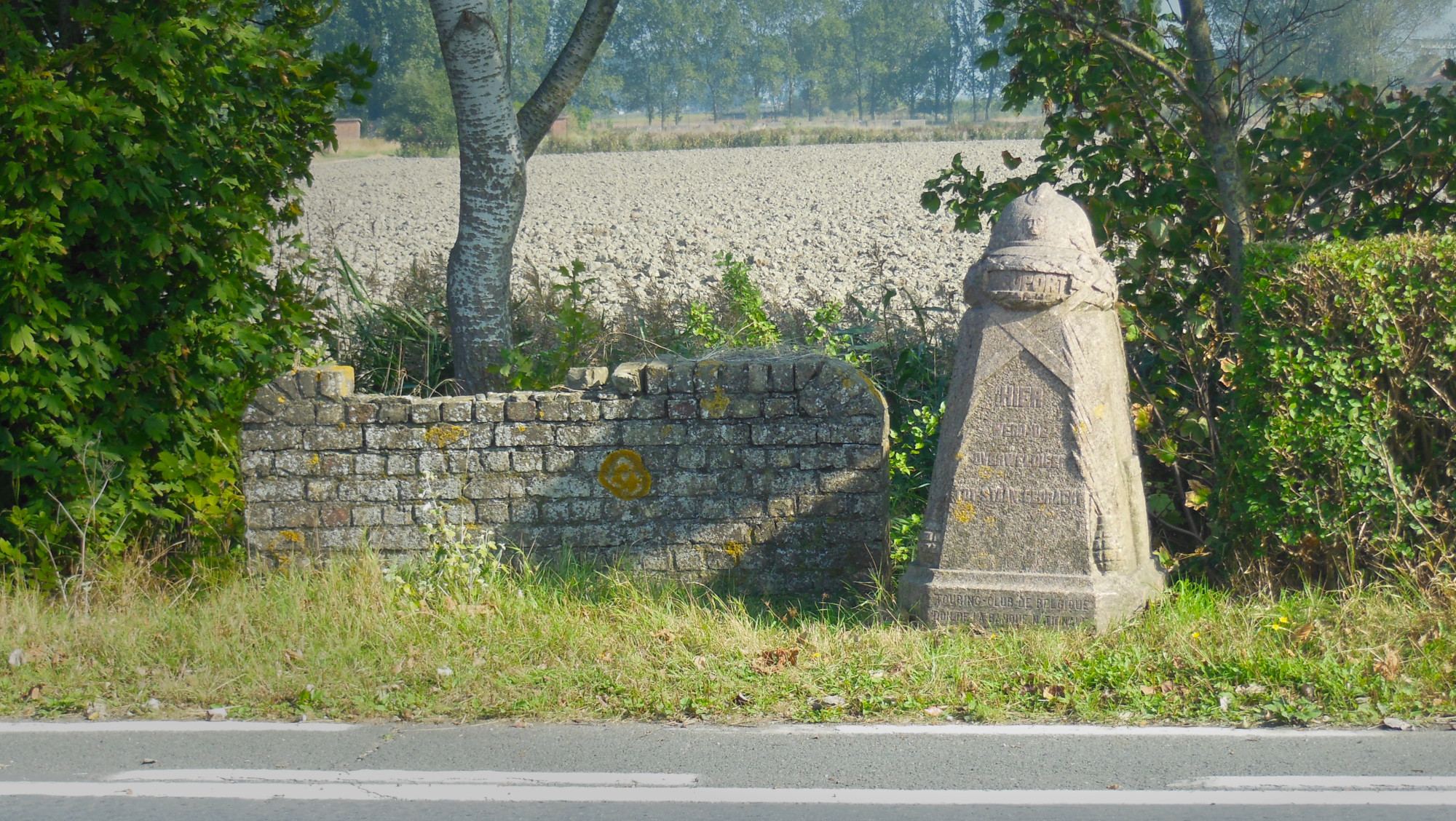
After a few hours’ work (including some distraction due to nearby unmapped stables), the 19 extant Belgian steles have all been found, added and homogenised in OSM and referenced to the database of Onroerend Erfgoed, the heritage agency of the Flemish government.

Tada: https://overpass-turbo.eu/s/1Wtx

See full entry

Меттиг: Zwarte Leen, Zillebeke, Ypres, Ieper, West Flanders, 8902, Belgium

As a friend and I were adding the 57th tag to a climbing gym in Belgium, I wondered what the element with the highest tag count is. I couldn’t find such stats (which may be a good thing), so I downloaded belgium-latest.osm.pbf from Geofabrik and wrote a simple Python script that uses Pyosmium to do some counting for me.

Without further ado: the Belgian record for highest tag count is… the relation for Belgium itself actually, which currently has 491 tags. The non-relation with the highest tag count is, boringly, the node for Belgium, with 288 tags. Next up are Brussels (156 tags), the Council of the European Union (79 tags), one particular section of the River Meuse that somehow got its name mapped in 57 different languages (65 tags) and the Irish embassy (also 65 tags). Next up is the first element that has a lot of tags not because it’s just flooded with languages! This maritime beacon north of Antwerp in the River Scheldt has a respectable 63 tags to describe all its lights. Our climbing gym is not far off from this one, and has a lot more diverse information in its tags I’d say.

I noticed that the relation for Belgium also has a high version number, it’s at its 1043th revision. That prompted me to take a look at version numbers too. But 1043 isn’t even close to our record, which goes to the superroute relation for the E40 (version 3141). Granted, that’s international. The version record for a purely Belgian object is the hiking route GR 126 (version 1103) from Brussels to Membre-sur-Semois. Just like with tag counts, I find it more interesting to look at non-relations here, though. There the honour for highest version goes to one of the outer rings of a farmland multipolygon south of Mons, which is at version 277. Funnily enough, in contrast with its senior version number, it almost has no tags to speak of, only a source!

See full entry

Multiple user accounts in JOSM

Арахецна M!dgard 5 July 2023, мотт: English ТӀаьххьара карладаккхар 6 July 2023.

I started taking on mapping commissions and I want to do those with a different user account. JOSM doesn’t have built-in support for multiple user accounts, so I created a script for it that lets me switch without pain. It works on a typical Linux setup or other *NIXes such as macOS, not on Windows.

It modifies JOSM’s preferences.xml file to change your credentials, and then launches JOSM. You create one copy of this script for each OSM user account, and run those instead of launching JOSM the normal way.

I created two files with this script in a directory in my PATH and made them executable: once as ~/.local/bin/josm and once as ~/.local/bin/josm_commissioned. For Linux desktops: If you want, you can also create .desktop files in ~/.local/share/applications so you can run these scripts easily from your main menu or launcher. Feel free to share those in the comments!

Find the OAuth key and secret in JOSM’s preferences XML file, and fill them in in the script. Especially for macOS, you may need to change the JOSM_PREFS and JOSM_EXECUTABLE paths.

See full entry

A fast workflow for taking and processing personal survey notes

Арахецна M!dgard 31 December 2019, мотт: English ТӀаьххьара карладаккхар 2 August 2023.

Taking private notes on a survey with OsmAnd and processing them with JOSM is a breeze. Here’s how.

With this workflow you’re able to enter geo-referenced text while surveying and copy-paste it in JOSM. I do this to i.a. enter opening hours on the go.

tl;dr: Create quick actions in OsmAnd to create notes. Don’t upload, but export the notes as GPX. Open in JOSM, convert to data layer. Remove a note node when it’s done. Remove all notes in OsmAnd.

Personal notes?

If you don’t choose to upload your notes, they stay private.

Setting up OsmAnd

  1. Enable the OSM editing plugin. (main menu → Plugins → tap the icon for OSM editing, it turns orange)
  2. Enable quick actions. (main menu → Configure screen → switch Quick action to on)
  3. Add a quick action for “add note”. (quick action → Add actionAdd OSM note → switch Show interim dialog to on, leave message empty)

To save typing on things you add a lot, also add one-click quick actions for them. (Create a quick action like before, but switch interim dialog to off, and fill in a message.) I have those set up for bicycle parkings with the standard capacities that can be found all around Ghent: 5, 10 and 15. For non-standard parkings I can still create a manual note.

After surveying

On the device with OsmAnd

  1. Export your notes as GPX. (main menu → My placesOSM edits → share icon → All dataGPX file)
  2. A “share” menu will pop up to send the result somewhere. Get the file to your computer somehow. Some suggestions:

On your computer

See full entry

Removing phone booths in Belgium

Арахецна M!dgard 28 July 2015, мотт: English ТӀаьххьара карладаккхар 6 January 2019.

Update: The mechanical edit described in this diary entry has been discussed on the Belgian mailing list. You should never do an edit like this without prior consultation with and consent of the relevant community/communities. Also make sure to read the Automated Edits code of conduct if you plan on making an automated edit. OpenStreetMap is generally not welcoming those, even when they follow all rules.

All Belgacom/Proximus telephone booths in Belgium are removed from the streets. With changeset #32926155 those that had operator=Belgacom or Proximus have also been removed from OSM.

The remaining phone booths before their removal. Most of them are near Brussels.

I used the following Overpass query:

/* Find all Belgacom/Proximus phone booths in bbox */
(
  node[amenity=telephone][operator~"[Bb]elgacom|[Pp]roximus"]({{bbox}});
  <;
  >;
);

out meta qt;

This fetched all phone booths and also any ways they are connected to. No relations were matched, which was good. Then, in JOSM, I did the following searches to obtain phone booths that are member of a way:

See full entry

Public transport

Арахецна M!dgard 30 November 2013, мотт: English

How should bus lines be mapped?

In 2011, this scheme was approved and according to the proposal page it is active. I took the time to learn it and I tried it out, but as far as I can tell, it is not supported well.

Apparently the wiki proposal page has not been cleaned up and not all of the information on it has been put on the page about public transport. I find this situation to be confusing.

If you know more about how to tag public transport or want to share thoughts, please contact me on my wiki talk page.

Меттиг: Magdalenakwartier, Brugge-Centrum, Brugge, Bruges, Brugge, West Flanders, 8000, Belgium