This is a random collection of thoughts from the last project of mapping a new area for emergency services.
… 查看完整日记文章
This is a random collection of thoughts from the last project of mapping a new area for emergency services.
… 查看完整日记文章
It was a dark and stormy night - no, not THAT dark and stormy night, but still a challenging situation! Imagine an emergency services reponder being tasked with rapidly finding a residence on an active call in an area of:
Last year, this situation led the local Slater-Marietta Fire District (FD) to post not just one , but two pleas for people to pay attention to driveway entrance and house markings.
While the local OSM community was importing cell towers in a nearby county, one of the mappers who worked on cell towers at the time noted that driveways would be very useful because of similar problems: the tower might not be visible from the roadway, and no clear marking for the tiny access road would lead to the tower. That statement and seeing the “Amazon driveway project” come to our area gave me a project idea for that fire district: review all roads, create all driveways, and enter all addresses - then have the EMS use a standard OSM navigation app to get turn-by-turn directions to their destination.
A mapping colleague established a working relationship with the county - although they don’t have open data, they gave OSM permission and access to image layers for 6 inch off-leaf aerial imagery and roads and addresses. After opening up separate task manager tasks for roads and buildings , the area was eventually completed and ready for navigation.
… 查看完整日记文章
Out of curiosity, I pulled some statistics on the US Rail network. This does cross into a bit of Canada and Mexico where the GeoFabrik extract approximated the boundary.
level_crossing	TOTAL	232167
crossing	TOTAL	8231

Rail_Bridge	47232
Rail_Tunnel	16394
Highway_Bridge	70811
Highway_Tunnel	8972
Total Layer Crossings 143409
A bridge or tunnel is counted as a single occurrence no matter how many rail lines are included. Each marked crossing node is counted, so a fully mapped rail yard could contain many crossing nodes.
For a closer look here is a breakdown of the top 20 categories of level_crossing - the first column is the type of ‘highway’, and the second column is the type of ‘railway’ in OSM:
residential	rail	112659
service	rail	29171
tertiary	rail	26789
secondary	rail	16717
unclassified	rail	12732
track	rail	10058
primary	rail	6734
residential	disused	1628
residential	light_rail	1547
residential	tram	1413
trunk	rail	1122
tertiary	light_rail	1114
secondary	light_rail	1059
service	light_rail	676
residential	abandoned	660
primary	light_rail	517
tertiary	tram	493
service	disused	435
tertiary	disused	372
residential	Unknown	371
residential	preserved	353
A type of ‘Unknown’ usually means that a node that joins ‘highway’ to ‘highway’ is marked as type level_crossing for example.
Similarly, here are the top 10 ‘crossing’ types:
footway	rail	2984
footway	light_rail	2083
path	rail	881
cycleway	rail	762
footway	tram	565
path	light_rail	116
cycleway	light_rail	96
footway	miniature	86
footway	preserved	62
residential	rail	56
service	rail	34
Note the presence of ‘residential’ and ‘service’ which are either newly incorrectly marked ‘crossing’s or a rail crossing at the junction of ‘residential’ and ‘path’ for example.
To see the complete breakdown to perform custom category groupings, obtain the raw .CSV files from Rail Crossing Counts
The group of railroad crossing challenges listed in the previous diary entries is now complete. Many people worked on these challenges to make this happen. The tasks seemed to get more difficult as the challenge neared completion, since each task would correct a single crossing at a time.
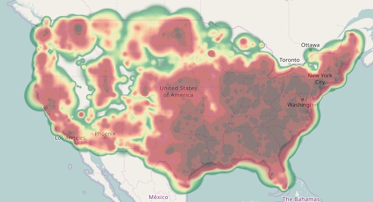
Many of the tasks involved original TIGER highway crossings with poor alignment. I also worked on geometric alignment of the crossing approach roads to match the aerial imagery. Although almost none of these would be cross-checked against GPS traces, Bing imagery is almost always a factor of 10 more precise than the worst of the TIGER data. The resulting edits may have an effect on “TIGER desert analysis” - the study of large untouched areas in the US. Those “TIGER deserts” still exist but would be smaller. My personal contributions heat map now mostly shows areas in the US where there were rail crossings that needed fixing:
… 查看完整日记文章
Update on challenge status:
Crossing Ways Rail-Highway 35.6% complete
Crossing Type Rail-Highway 53.3% complete    Both types of pedestrian crossings are 100% complete.
I’m taking time to do geometric repairs as well. The result will be a reasonably correct road network near rail crossings.
The links to the remaining challenges are:
[Crossing Ways: Highway-Railway, US] http://maproulette.org/map/980
[Crossing Type: Highway-Railway, US] http://maproulette.org/map/990
As previously mentioned in diary entry osm.org/user/MikeN/diary/39782 , the MapRoulette Rail challenge uses topological analysis of the rail network to generate the task list. Many tasks land on a multi-track crossing or include a rail yard, so many tasks correct fix more than 1 crossing per edit session. Also, anyone routinely reviewing an area might correct rail crossings outside of MapRoulette By re-analyzing current OSM data, finished tasks were marked off. Some findings for the last interval:
Because the first MapRoulette tasks are more likely to land on in a ‘busy’ area, future fix rates and node correction to task ratio will probably fall as each task is more likely to point to an isolated crossing.
Many tasks end up making geometric corrections to the rails and surrounding roads.
The links to these challenges are:
[Crossing Ways: Highway-Railway, US] http://maproulette.org/map/980
[Crossing Ways: Pedestrian-Railway, US] http://maproulette.org/map/989
[Crossing Type: Highway-Railway, US] http://maproulette.org/map/990
[Crossing Type: Pedestrian-Railway, US] http://maproulette.org/map/991
There was a moment of panic as the analysis also discovered thousands of new tasks! This had 2 causes:
One class of quality improvements in the US is Railway Crossings. The original TIGER import mostly connected railways to highways or crossed with a duplicate but unconnected road. There was no bridge or crossing information to assist.
It can be useful to have railway crossing information available for navigation. In 2015, MapRoulette defined a challenge to review all railway crossings. The first version of the Railway Crossings challenge at MapRoulette used the points defined by the US Federal Railway Authority. Many of these crossings had already been corrected by map editors during normal QA. The challenge began with 120K crossings to review. This was reduced to some 70K points by the time MapRoulette V2 came out. The partially completed challenge was not migrated because the MapRoulette V2 features were being tested and improved. Although this is not the ideal type of task for MapRoulette, I enjoyed being able to knock out 5 in a row without much effort (unless in KY, PA or WV!) It also is ideal for an armchair challenge - only a few are difficult to make out from the air.
Because I would typically correct nearby crossings when fixing a task (others may have also), I wondered if identifying remaining crossings with a topological analysis would result in fewer false positives, and fewer already-completed tasks to review. So I set up a POSTGIS instance and tried to construct queries that would identify problem crossings. That proved to be too difficult:
… 查看完整日记文章