Nighto's Comments
| Changeset | When | Comment |
|---|---|---|
| 27318976 | 4 months ago | Oi Raquel, não conheço a plataforma mas acho que não é automático. Enfim, apaguei os dois bicicletários neste changeset. Obrigado! =) osm.org/changeset/164373206 |
| 27318976 | 4 months ago | Oi Raquel, obrigado pela sua mensagem. Desculpa, qual dos bicicletários foram removidos? Todos? Não consigo ver o comentário no StreetComplete infelizmente, tentei aqui mas parece que só está disponível para Android e uso iPhone. |
| 150750904 | over 1 year ago | Olá Pedro, sim com certeza, estava apenas a atualizar com base em uma notícia que falava especificamente sobre o monumento. https://portocanal.sapo.pt/noticia/347141 |
| 27318373 | over 1 year ago | Thanks! |
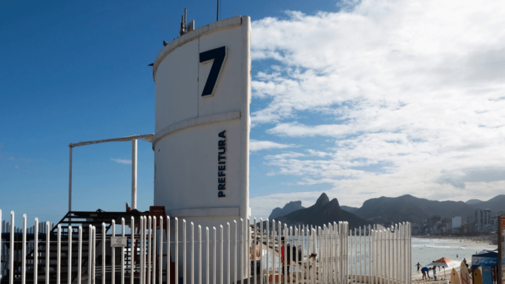
| 27318373 | over 1 year ago | This picture is a bit better, you can see the life guard on the top and a plus sign / red flag indicating that: https://lh5.googleusercontent.com/XUbegMYen3e3rsMXnIZ1Bxn117XPJUOyzYt8itNfOE-1vjbWzkwzXdWtZTsYpjdbBdMN9qLIY-bMJ8oIn4zavhH39eyCZYsKYa6SHvMQ8lFYPQvTxJOAmnpb-UKWGfWCxpQo_jV_LUxOJMiQ3V3fWrBg6RW8Tx9EfwHfYGbJ0SqXMnunOMRXUvvXyvAcPoHjSbm6fA |
| 27318373 | over 1 year ago | Hello os-emmer, thanks for checking out points created such a long time ago :) Rio de Janeiro beaches have this structure: https://blog.hurb.com/wp-content/uploads/2022/09/posto-7-praia-rio-de-janeiro-1024x576.png They are called "posto" and always have a number, so they are references on the beach, like "Let's meet at Posto 12". It's a two-store structure, on the bottom there are (paid) toilets and showers, and on the top there are lifeguards which look for people drowning in the sea. It is not open 24/7 as they have fences, that are closed after their opening hours. That's why they're emergency=lifeguard + amenity=toilets. I do understand if you would prefer tagging them separately though. Why it is tagged with that typo I honestly don't remember, most like indeed a typo or maybe the tag was different back then? But yeah please be welcome to fix it :) |
| 61127825 | over 1 year ago | Good question. I probably copied the name from the IBGE layer and forgot to remove the noname tag. Just fixed the way by removing it. |
| 143013727 | over 1 year ago | Hello Mateus. Thanks for checking it and fixing the noname tag. I have checked with a person who works on the Geo department on the City Hall and indeed this segment has no name. This discussion happened publicly on the OSM Rio de Janeiro telegram channel on October 23th, 2023 (same day it was edited). |
| 130238621 | over 2 years ago | Sorry, will keep that in mind for a next time. |
| 128334422 | almost 3 years ago | Just FYI, discussed with Wandrer.earth author (Craig) and he mentioned someone else already informed him about the NL rules for foot being implicitly routed on cycleways without foot=yes. He is working on a fix on his side. Sorry for the noise and thanks again for spotting Kim Sapalot. |
| 128334422 | almost 3 years ago | Reverted with changeset 128396070. |
| 128334422 | almost 3 years ago | Oh, that's good to know. I had the issue with Wandrer.earth, which uses OSM data to know what routes you have visited at least once based on your Strava activities. In this example, it "paints blue" the roads you've visited near your activity, but notice it will not paint the ways which have highway with sidewalk=separate that does not have a footway adjacent to it. So I might have to file a bug report to the tool author and revert this changeset. Thanks for spotting it! |
| 117708058 | over 3 years ago | Por favor verifique a documentação de station e tram_stop em: osm.wiki/Tag:railway%3Dstation e osm.wiki/Tag:railway%3Dtram_stop |
| 117708058 | over 3 years ago | Olá Marcelo, tudo bem? As etiquetas que você utilizou não devem ser utilizadas no VLT, já que suas paradas não são estações de transporte sobre trilhos pesado (trem / metrô) de acordo com a definição da etiqueta railway=station. As paradas do VLT devem ser mapeadas como as paradas do Bonde de Santa Teresa (railway=tram_stop). |
| 115604346 | over 3 years ago | Oops, thanks for spotting the typo :) |
| 114113772 | over 3 years ago | Vendo imagens do Street View (não para copiar um eventual nome, mas para verificar a existência de placas) não consegui ver nada, assim como não encontrei nenhuma referência online. Acredito que a nota possa ter sido vandalismo (já que o nome em questão é de um youtuber que gera alguma polêmica), mas pode ser só um falso positivo mesmo. |
| 114113772 | over 3 years ago | Olá DressyPear4, qual a fonte para o nome da subestação? Não consegui achar em outra fonte. Obrigado. |
| 92068231 | over 3 years ago | Vandalism edit, should be reverted |
| 112446931 | almost 4 years ago | Gotcha, thanks a lot :) |
| 112446931 | almost 4 years ago | By the way something I was wondering. I see that in this area many buildings have their POIs (stores etc.) as nodes instead of the building way. Is this on purpose? Is it ok if I merge such features? (i.e. copy the tags from the node to the way and remove the node) |