OpenStreetMap logo OpenStreetMap

Pieter Vander Vennet's Diary

Recent diary entries

Press attention for the surveillance camera walk

Posted by Pieter Vander Vennet on 25 November 2024 in English. Last updated on 2 December 2024.

In the past weekend, I did (two) walks in Ghent where we used https://mapcomplete.org/surveillance to spot surveillance cameras. The press was interested as well, resulting in some interviews and articles!

Those are in Dutch of course.

The local TV did a decent job: https://avs.be/nieuws/openstreetmap-vrijwilligers-brengen-cameras-in-gent-in-kaart

The newspaper article: https://www.hln.be/gent/vrijwilligers-trekken-door-gentse-straten-om-alle-cameras-in-kaart-te-brengen-een-half-miljoen-hangen-er-in-dit-land-maar-niemand-weet-exact-waar~a8b9341c/ which isn’t to bad as well (paywalled, without paywall: https://archive.ph/4GUZQ)

And on VTM: https://www.vtmgo.be/vtmgo/afspelen/e9e73a3b-b932-400a-91b9-af78622cbbaf (starting at 20:30, account required; I wasn’t able to rip it)

Edit 2024-12-02: the local municipalities also wrote about it: https://www.wvigisco.be/tips-en-tricks/open-data/openstreetmap/vrijwilligers-inventariseren-bewakingscameras-met-mapcomplete/

(If you don’t want to create an account, you can also find them on my NAS)

Location: Waalse Krook, Ghent, Gent, East Flanders, 9000, Belgium

As you might know, I’m the main developer of MapComplete. For those who don’t know, MapComplete is an OSM-viewer and editor, where contributors can easily answer questions, add new points and upload pictures from a POI from a cozy website. Instead of showing all data at once, it only shows one items within a single topic, resulting in many thematic maps to choose from.

Four years ago, I started with uploading images to IMGUR, a “free” (paid for by advertisements) image host. They were really permissive at the time, and I got the API up and running in about 15 minutes. For the past four years, they served us well with barely any trouble. They rarely had outages and if there was one, it only lasted a few hours at most.

But it was not meant to last. The first crack in this relationship was a little over a year ago. Igmur changed their terms of use, making clear that they would remove “images that aren’t watched often”. In practice, this was mostly meant to remove NSFW pictures from there platform, but it was a good excuse for us to start backing up all the imgur images linked to from OpenStreetMap.

The next omen was the change of terms. From being very permissive, those went to “please, don’t use IMGUR as your Content Distribution Network”, which pretty much is how MapComplete used IMGUR. Oops. In this forum thread, I wrote “I hope IMGUR wouldn’t notice us before MapComplete made the switch to Panoramax”.

Famous last words.

About a week later, our upload got blocked. Contributors were not able to upload new pictures anymore

As such, Thibault Mol setup a Panoramax instance to be used with MapComplete (thank you very much for this!). I spent quite some time to change MapComplete to support panoramax as backend, making uploads possible again!

This has been notable in the graph by TagHistory for Panoramax: one can notice the graph going steeper during october:

See full entry

How to verify your OpenStreetMap-account on Mastodon?

Posted by Pieter Vander Vennet on 9 November 2024 in English. Last updated on 13 June 2025.

Hey all,

If you want to verify your OSM-account and get that nice badge, this is possible.

UPDATE: since june (or was it may?) 2025, the OSM website introduced “social links” in the user profile. You can link your mastodon account in there and save. (*)

Then, on your Mastodon-account, go to Preferences > Public Profile. Under ‘extra fields’, set ‘OpenStreetMap’ to the left and a link to your account to the right.

(*): Previously, one had to add a html-link with rel="me" attribute into the user profile.

MapComplete: 2023 in review

Posted by Pieter Vander Vennet on 15 January 2024 in English.

2023 in review

Now that 2023 has come to an end, it is an appropriate time to take a look back and see what has happened within the MapComplete-sphere.

2023 also marked the year that I (pietervdvn) received a grant by NlNet, meaning that I could spend a ton of time on improving MapComplete - and with success.

Looking back, a humongous amount of work happened. I’m giving a quick recap here.

User survey and other statistics

I’ve started the year with orienting myself. I ran a user survey (part 1, 2 and 3) and analyzed how mapcomplete was used. For example, there are some interesting statistics about the number of pictures created and about the reviews that were made

Lots of improvements

Most of the work of course went to programming MapComplete, which underwent a few big changes (notably the UI-framework and Mapping-library) and received numerous small improvements.

A quick recap:

Svelte (Q1)

The first big change of the year was switching to an actual frontend framework. MapComplete was written in a hand-rolled framework, which wasn’t very performant. And while I really loved it, using Svelte made the frontend more approachable for other programmers, more maintainable and faster.

Svelte was chosen partly because it works and has a large ecosystem, but also because it turns out to be conceptually similar to the previous, handrolled framework. Even better: the old framework is so similar, that they can be used together! With a few tweaks and adaptions, they were made compatible.

The big advantage of this compatibility is that it becomes possible to gently migrate. Instead of porting everything at once, component per component can be switched when the time is right. As such, there are still a few components around written in the old framework, but they are slowly getting replaced.

See full entry

This is part two which highlights the results of the OSM user survey. Read part 1 about demographics and identity and part 2 about the favourite maps

How well-known is MapComplete?

Not that well-known, it seems. In the previous question, 11 people out of 59 who took the time to fill out this question, mistook MapComplete for StreetComplete. This is a clear sign that there is still some work to do.

How did people get to know MapComplete?

How did people get to know MapComplete in the first place?

Via Reddit (13 mentions), Twitter and Mastodon (13 mentions) and the Weekly OSM (9 mentions).

There are honorouble mentions for online chatrooms (6 mentions), word of mouth (6 mentions), the OSM-forum (3 mentions) or ‘arriving via a specific map’ (3 mentions).

From these results, it’s clear that the online spaces where I regularly pitch MapComplete (namely Reddit and Mastodon) also resulted in some people discovering MapComplete.

However, this makes me wonder how applications such as StreetComplete and EveryDoor got to such a big userbase quickly. It seems that creating a mobile phone app with offline capabilities helps with this.

Good questions to ask next year?

I’m planning on doing a similar survey next year (or in one year and a half) to see how things evolve. To be able to compare results, it is interesting to have the same questions, even though some improvements can probably be made (e.g. in wording and more nuanced options).

It is also hard to gauge if people are part of a marginalized group. As such, it is hard to know if we reach those people as well.

But there might be room for other good questions. If you have suggestions, feel free to let them know

Anything else you’d like to say?

This was the question with the most uplifting answers, as many, many people wrote in a compliment about how much they like MapComplete and the work I did! (Well, some of them were probably thinking about StreetComplete)

Thank you everyone involved!

Conclusions

See full entry

This is part two which highlights the results of the OSM user survey. Read part 1 about demographics and identity here

Which thematic maps do people use?

56 people gave insight in their favourite maps, yielding a total of 86 mentions of specific map themes or groups of themes.

The theme with the most mentions -namely 9- was the etymology theme. This is not a big surprise, as there has been a tremendous amount of changes made with Open Etymology-map. Some people mention curiosity for their local environment, others are interested in the link between OpenStreetMap and Wikipedia. It should be noted that nearly everyone who mentioned etymology indicates that they have hundreds of edits.

The second place goes to the waste theme with 8 mentions. I have to be honest, this came as a total surprise to me! At first sight, it is a bit of a boring topic - especially when contrasted with something like etymology. Yet, everyone needs to get rid of some waste every now and then. By the way, this theme was created by @Rlin and I have to admit that this is one of the most polished themes on MapComplete, using a lot of the available functionality. Thank you!

The third places goes to all cycling-related themes (7 mentions of ‘cycling’). Cyclofix had another 5 mentions, resulting in 12 total mentions. This was no surprise either, as cyclofix has been historic driver of many changes made with MapComplete. It is one of the oldest maps on MapComplete, yet it is still popular and is embedded on a few websites.

The third place goes to benches with 7 mentions - another very down-to-earth topic but with lots of value and lots of unmapped features.

Out of the other answers, it is clear that there are various reasons to use MapComplete:

See full entry

The MapComplete user survey results: Part 1: user demography

Posted by Pieter Vander Vennet on 8 March 2023 in English. Last updated on 11 March 2023.

MapComplete user census

As you noticed, MapComplete ran a user survey during january. What did it tell us?

The use survey had a few goals, namely:

  • discovering what demographies are using MapComplete (and which are missing)
  • and discovering what needs and wants are still there

Basic demography

The first question is of course: who did fill out the survey? If we look to the numbers, a clear pattern emerges.

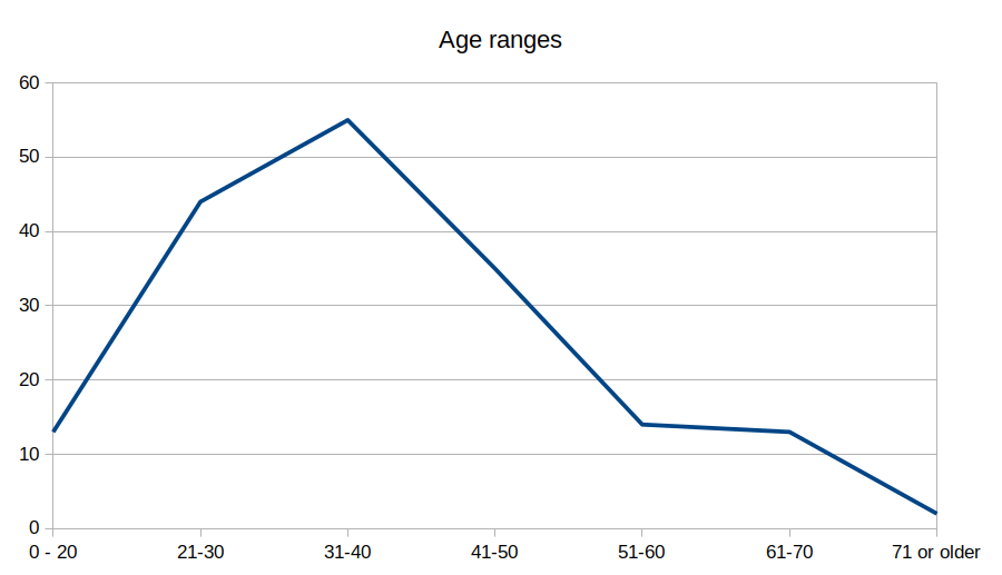
The age distribution looks pretty normal - there is a clear peak around the bucket 30-40, which falls down left and right.

The gender is not as balanced. Unsurprisingly, the majority of respondents is male:

See full entry