
There are a couple of proposed tagging schemas for intense mappers to map street areas and road markings to enable a much more detailed road rendering with accurate widths and lanes.
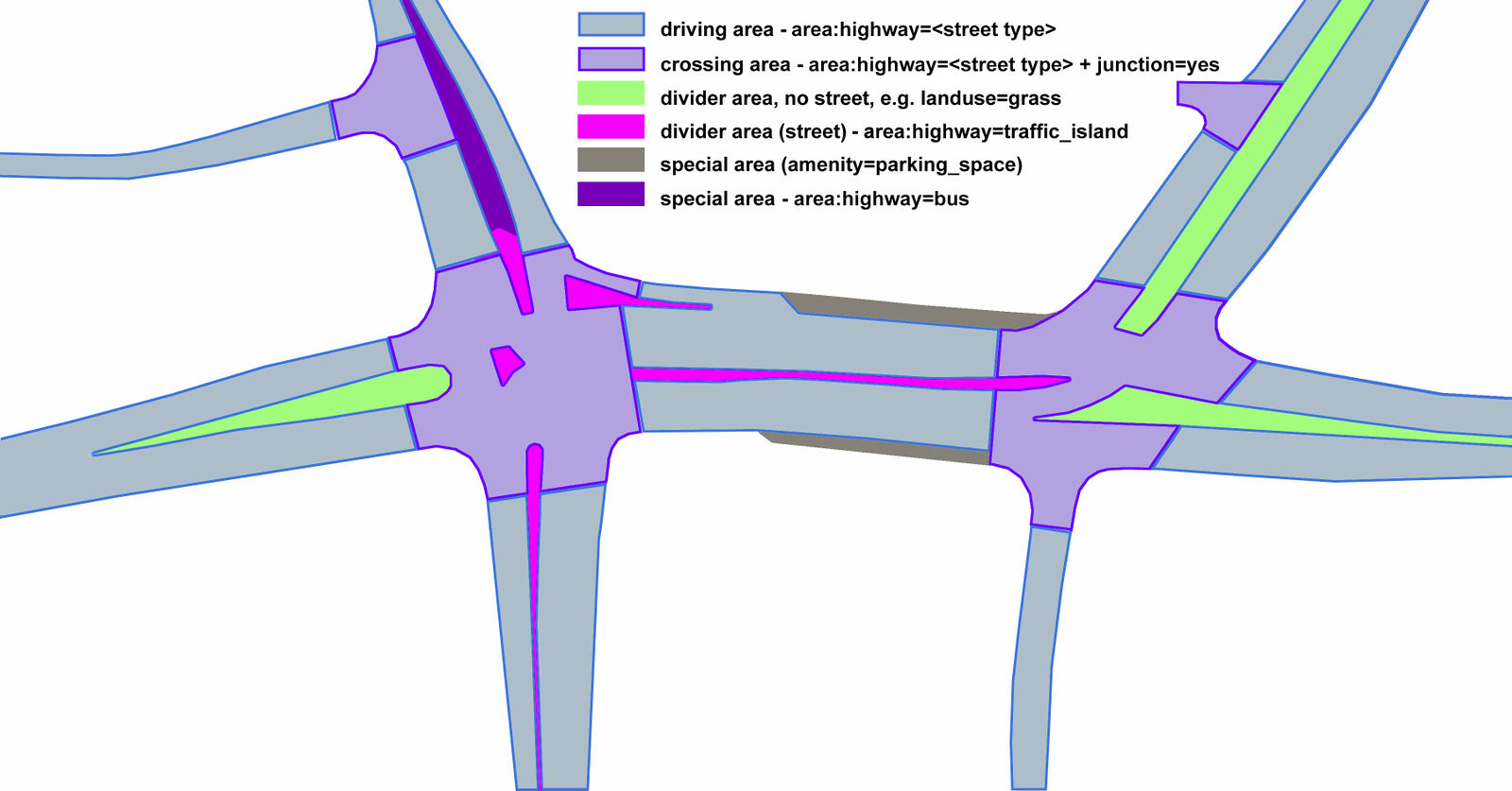 Proposed tagging schema for street areas
Mappers are already active in Poland using this proposal and also have a renderer in place to visualize this with pretty impressive results.
 Road area tag rendering from OSM Poland
The next level is going to be having accurate lane marking within the surfaces, but it looks like till date there has been no successful attempt to render roads to such a level of detail. A few weeks ago, Rasagy from Mapbox wrote about styling individual lanes using the Studio tool. The approach uses individual lanes geometries and seem to give good results, but involves a lot of mapping effort.
 An attempt to style individual lanes using Mapbox Studio
If anyone is interested to try their hand at styling roads to such level of details, there is a sample intersection that has been traced by Chetan_Gowda and Fa7C0N on the OSM sandbox in Manhattan. If you are using Mapbox Studio, you can directly start styling the data by adding this tileset to a new style. Alternatively, you can use a geojson of the data to use in any other styling tool or to just explore the tags used.
Looking forward to seeing any interesting experimental outputs :)
Discussion
Cummentu dae BushmanK de su 10 freàrgiu 2017 a is 18:03
Just a quick reminder. Usage of
amenity=parking_spaceon the first illustration is incorrect.amenity=parkingshould be used instead.Cummentu dae Warin61 de su 10 freàrgiu 2017 a is 21:39
Divider Areas
These can be grass… or concrete, rock, shrubs, trees. They are not always grass. https://upload.wikimedia.org/wikipedia/commons/thumb/1/1c/Sydney_-Newcastle_freeway_north_bound_at_Berowra.jpg/270px-Sydney-_Newcastle_freeway_north_bound_at_Berowra.jpg
https://upload.wikimedia.org/wikipedia/commons/thumb/e/e8/Jolls_Bridge_on_the_F3Freeway-north_of_Hawkesbury_River%2C_N.S.W..jpg/220px-Jolls_Bridge_on_the_F3_Freeway-_north_of_Hawkesbury_River%2C_N.S.W..jpg
https://upload.wikimedia.org/wikipedia/commons/thumb/7/78/Hume_Highway.JPG/220px-Hume_Highway.JPG
https://maps.six.nsw.gov.au/arcgis/rest/services/public/NSW_Imagery/MapServer/tile/19/313977/482329
In addition there are ‘runoff areas’ at the side of roads. Sometimes used to provide services such as lighting, water drainage, emergency parking/phone.
I thing the best way of tagging these is to use landuse=highway for the areas. The landcover tag can also be used in addition to specify the cover used.
Cummentu dae BushmanK de su 11 freàrgiu 2017 a is 00:08
@Warin61, that picture says “e.g. landuse=grass”, so it is completely correct since it is just an example.
Cummentu dae Warin61 de su 11 freàrgiu 2017 a is 02:02
@BushmanK .. yes the whole thing is an example. It may have been better to give a link for the stuff that is left out.
In that example other kinds of divider areas have area:highway=traffic_island … from wiki.openstreetmap.org/wiki/Proposed_features/Street_area .. dated 2011.
Nothing in the above proposal encompasses the whole area that is used by the highway e.g. the verge … I would think something similar to landuse=railway would be appropriate.
Cummentu dae Alexandre Magno de su 17 freàrgiu 2017 a is 22:51
The result is cool and imprecise.
Cummentu dae dieterdreist de su 24 freàrgiu 2017 a is 06:43
I agree with Warin regarding the landuse=grass. Although you can find this frequently, it should really be landuse =highway in most cases. “grass” isn’t a use anyway