Лягатып OpenStreetMap OpenStreetMap

Дзёньнік PlaneMad

Апошнія запісы ў дзёньніку

How to find the changeset details of any OSM map feature

Дасланы PlaneMad 8 Жнівень 2018 на English. Апошняе абнаўленьне 9 Жнівень 2018.

Wrote this quick guide after realizing its not so easy to find how to do this.

Visible features

The easiest way to find more details about any feature that is visible on the map is to use the Query features tool. Use to to query the map features at any point to find the object you are looking for.

Alternatively, you can also use the search box and directly search by the name of the feature for matching results worldwide.

Deleted features

Deleted features that you know were visible in the past is slightly more tricky. You can use this Overpass Turbo Attic query to query all features in the map view at any given historic date to find the object you are looking for.

Tip:

See full entry

Descriptions of OSM tags in any language using Wikidata

Дасланы PlaneMad 10 Студзень 2018 на English. Апошняе абнаўленьне 12 Студзень 2018.

Ever wanted documentation of OSM tags in your own language?

Thanks to Wikidata, this might be quite simple: OSM tags in Japanese | German | English
(Hit edit query to change to your language)

If you find a missing tag or translation, you can add it by editing the relevant Wikidata item and adding a new translation or a new OSM tag property.

The post was inspired by a recent discussion on OSM wiki questioning the value of Wikidata links on the wiki pages. Atleast in my part of the world, this is going to be quite useful since the Wiki pages have not been translated into my language.

Note It is known that OSM tags don’t always map 1:1 exactly with existing Wikidata concepts and such derived definitions need further review to make sure it is consistent with the OSM Wiki. In such cases a new concept can be created in Wikidata if it does not overlap with any existing definition.

Viewing OpenStreetMap tiles in GL

Дасланы PlaneMad 22 Снежань 2017 на English.

Was fiddling through the Mapbox GL JS API today, and thought i’d see if I can get the default OSM raster tiles to render on GL. Turned out to be surprisingly easy using this example.

Result:

Demo+code: http://bl.ocks.org/planemad/5670e14b67e3eb82b707ba46c9d3010f

Notes:

  • The OSM tiles are raster which are rendered at discrete zoom levels, but the GL interface allows for smooth scrolling. The result might be slightly blurry tiles and may not be as crisp as viewing them in Leaflet.
  • The original example was for adding a WMS layer. So any external TMS/WMS layer should work by swapping the tile url in the code. See osm.wiki/Tile_servers for options.
  • The color transition of the tiles from b&w was achieved using the raster-saturation property and zoom functions. Not sure if this is practically useful, but definitely avoids needing to render separate b&w tiles.
  • An alternative to using Mapbox GL JS for viewing the OSM tiles in GL is to use OpenLayers

This Friday, I will be at SOTM in Aizuwakamatsu, Fukushima this weekend talking about the state of validation on OpenStreetMap! I will talk about the need for making a validated error free map with OSM data, the recent efforts of the Mapbox Data team to review OSM changes and what the future of data validation might look like. If you are interested to attend the talk, grab a seat in the main hall at 4:10pm on Friday at the Aizuwakamatsu City Culture Center.

If you are interested in a deep-dive into validating edits in your area on OpenStreetMap, attend Validating the Map workshop conducted by manoharuss on Sunday at 1:30pm in Room-1.

image

_Distribution of reviewed and validated changesets using OSMCha in 2017 View Interactive Map_

Visualizing Turn Restrictions

Дасланы PlaneMad 10 Жнівень 2017 на English.

A turn-restriction defines restricted or mandatory turns at a junction and are one of the most important features to map for accurate driving directions. Thought I would quickly make a comparison of how different map data editors visually represent this feature for mappers. Pick the best:

OSM

See full entry

Comparing GIS and OpenStreetMap data

Дасланы PlaneMad 1 Чэрвень 2017 на English.

Usually when meeting old timer GIS users in academia or government, there are a bunch of questions I get asked about how OSM data fits into the more traditional GIS model where data is organised into shapefiles and layers.

Since I could not really find a simple article which explained the difference, spent a few minutes today to come up with a (possibly) easy to understand benefits table for someone in Government. Its not technically accurate, but could quickly help pitch the idea for opening up more data.

Its still very rough, feel free to contribute any suggestions/improvements that could make this useful.

Just created a couple of mapping challenges for the Wikidata enthusiasts:

There are over 8,000 important places on the map with neither a Wikipedia or Wikidata tag. These challenges are a great way for mappers interested in Wikidata as well as Wikidata contributors to get started with OSM. Do spread the word in your local communities and share your feedback on how to improve the challenge.

Edits from StreetComplete

Дасланы PlaneMad 5 Красавік 2017 на English.

While reviewing edits in my neighbourhood, stumbled on a lot of edits by a new editor called StreetComplete. Streetcomplete seems like an open source map editor on Android to quickly add missing metadata to OSM around your location like streetnames, road surface opening hours etc. using a simple form based UI.

Github: https://github.com/westnordost/StreetComplete

Curious, I listed all the changesets from StreetComplete using osmcha and was surprised to find over 30,000 changesets since the first one in Nov 30 last year. Just yesterday, there was 2,700 changesets uploaded, so there seems to be a sudden surge in editing activity.

The edits in my city were mostly adding the road surface and looked quite good, and its exciting to see such well designed tools driving new contributors to the map. If you are curious use osmcha bbox filter to review edits from StreetComplete in your area and share any observations on the editing activity.

Lets have changeset mentions

Дасланы PlaneMad 3 Красавік 2017 на English.

On an average, there are atleast 40 data reverts per day. Most changesets comments are non descriptive like revert previous change making it very hard for the community to track the action and any previous changeset or discussion.

It would be really useful if OSM implemented a changeset mention feature like GitHub, where if I fixed a changeset with a comment Remove duplicate features added in #47398827, it would automatically add a comment to the original changeset and notify the original mapper and anyone in the community know what action was taken. This would greatly improve the social aspect of mapping and link discussions over multiple changesets.

Any other cases where this could be useful?

Interesting lists of changesets by new mappers

Дасланы PlaneMad 31 Сакавік 2017 на English.

Montauban, France vandalized

Дасланы PlaneMad 23 Сакавік 2017 на English.

A new user deleted over a 100 features including the place node in the centre of Montauban, a large town in France.

Just reverted both these changesets:

Caught and reverted in 15 hours! A few tools where one can review changesets from new users apart from the history tab:

Месцазнаходжаньне: Villenouvelle, Issanchou, Montauban, Tarn-et-Garonne, Occitania, Metropolitan France, 82000, France

Harare gets a new name

Дасланы PlaneMad 21 Сакавік 2017 на English.

Yesterday, Paris became a bicycle shop named France and today the Zimbabwe capital Harare became Hwinidi offices. This time the edit was from iD. The Mapbox data team caught this while reviewing edits on https://osmcha.mapbox.com/ around 13 hours after the edit.

Месцазнаходжаньне: Braeside, Harare, Zimbabwe

Paris is a bicycle shop

Дасланы PlaneMad 20 Сакавік 2017 на English.

The Paris city node got renamed to France and tagged with shop=bicycle yesterday. This was found and reverted by user:Chetan_Gowda from the Mapbox data team 27 hours later. For some reason the tiles still show a shop, while the name has got fixed.

While inspecting the Paris node, another user seemed to have renamed the French name to Algerie 6 month ago. This was fixed after 4 hours.

Both edits came through Maps.me, but this is just as simple an edit through any other editor. Its surprising no local mappers noticed this.

Месцазнаходжаньне: Quartier Saint-Merri, 4th Arrondissement, Paris, Metropolitan France, 75004, France

Generating a list of all the cities in the world with Wikipedia links

Дасланы PlaneMad 8 Сакавік 2017 на English. Апошняе абнаўленьне 9 Сакавік 2017.

A small tutorial on how one can export a CSV of all the cities in the world with their associated Wikipedia and Wikidata pages. This is useful if you want to do some spreadsheet analysis of data from OpenStreetMap.

Overpass Turbo is a great way to quickly extract data from OpenStreetMap by querying tags. An easy way to generate the query is to type “city” or the specific tag “place=city” in the wizard. Since most cities are tagged as just a point node, we can remove the query for ways and relations.

Also instead of the default geojson output, you can use the CSV output format and specify the the data columns to export. The end query looks like this:

[out:csv(::type,::id,name,”name:en”,wikipedia,wikidata)][timeout:200];

( node[“place”=”city”] ({{bbox}}); );

Try the live query (takes around 2 minutes to run) View results

See full entry

For the curious, the crowdsourced open knowledge database - Wikidata has a property for OpenStreetMap tags that can be used to tag items that describe the same/similar object on the Wikidata database.

It took some time to understand how Wikidata items are described having been used to the more flat OSM tagging model, but we can use a simple example of the popular OSM tag of that is used for any human settlement as a start.

Finding a Wikidata item describing an OSM tag

Any notable topic that exists on Wikipedia will exist as a Wikidata item. Hence any widely used OSM tag should be easy to match to a Wikidata item. For example, cities are one of the most important features of maps, and from the OSM Wiki we know that this feature is described on the map using the Tag:place=city.

If we can find a Wikipedia page that describes the same concept as the OSM tag, we can get the associated Wikidata item from the sidebar links of the page. The Wikidata item for a city is Q515.

See full entry

Finding dragged nodes

Дасланы PlaneMad 17 Люты 2017 на English.

Stumbled upon this mistakenly dragged node thats been hanging around Sheffield for the last two months. Considering its not fixed despite having a highly active mapping community, wonder if some tooling could have helped flagged this to local mappers sooner.

screenshot 2017-02-17 18 33 50

Ideas on how to prevent such edits in future? Any existing QA tools that highlight this?

Месцазнаходжаньне: Stannington, Bradfield, Sheffield, South Yorkshire, England, United Kingdom

Rendering detailed road areas

Дасланы PlaneMad 10 Люты 2017 на English.

There are a couple of proposed tagging schemas for intense mappers to map street areas and road markings to enable a much more detailed road rendering with accurate widths and lanes.

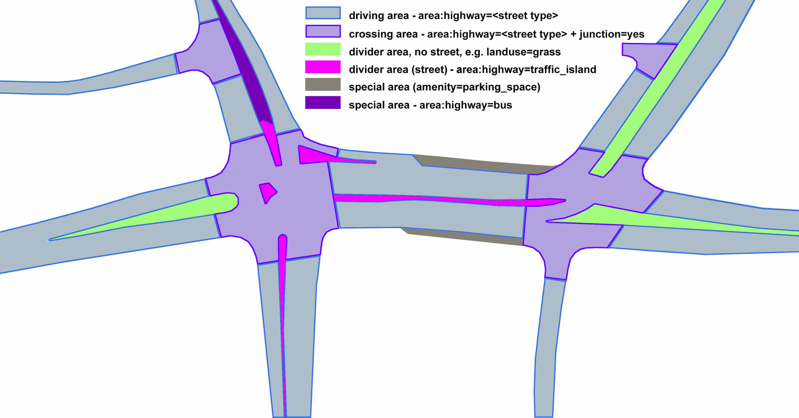
Proposed tagging schema for street areas

Mappers are already active in Poland using this proposal and also have a renderer in place to visualize this with pretty impressive results.

See full entry