I'm rewriting the tag editing code in Potlatch to be a bit more reliable at the moment... and it's taking longer than expected. So, sorry for the lack of updates. 0.8 will be along as soon as I can finish it...

Richard's Diary
Recent diary entries
Well, almost - a couple of tiny roads in West End (out from the main town) aren't done. But everything else is. Coupled with messpert's amazing work in Witney and the usual suspects around Woodstock et al, West Oxfordshire could be complete before too long...
Yesterday, Steve Chilton, Tom Higgy and I met up for a quick mapping blast around Worcester - one of the few cities in England to have very little OSM coverage.
I tackled the area west of the river, where I'd previously done an afternoon's mapping. It's now mostly complete save for the St John's and Rushwick areas. (Steve worked on the Barbourne area and Tom on the Diglis area, I think.)
And Steve managed to find a table under an out-of-copyright map in the Plough!
Still lots to do in the city, and I'll certainly return to finish off the west side at least, but it's now in a much healthier state than it was before the weekend.
It's now 3.19am and I can't let the last two nights' effort go without showing something of what I've been working on...

There's huge amounts of code tidying to do, plus calibration for every single sheet, before I can get England and Wales complete and ready to upload. And even this is only on one zoom level (14). But it all gets easier from now on!
You can now choose from several background layers in Potlatch.
Go to the options window (the little "tick" near the bottom left), and you'll see that the pop-up menu which used to offer only 'Yahoo' and 'None' now offers:
- OpenAerialMap
- Yahoo
- Mapnik
- Osmarender
- Maplint
OpenAerialMap is likely to be particularly useful. Not just because it's a great project in itself, but also because it uses the same low-res Landsat imagery as Yahoo - but enlarges it when you zoom in. So if you want to trace over enlarged Landsat, use this to replace the old Flash Player zoom.
(If anyone else has spherical Mercator GMaps-like tilesets that might work as a background image, let me know.)
Thanks to Christopher and Jon for configuring their servers (OAM/tah and tile respectively) so Potlatch can do this.
And for just one example of how it looks, go to osm.org/edit.html?zoom=16&lat=49.795&lon=15.445 and select OpenAerialMap!
0.7 is now live (thanks Tom) and has just one big improvement: it now fills your browser window.
So please be nice to the server and don't go full-screen at 2048x1024 on zoom level 12 in London!
One of the good things about this is that the greater screen space should give room for more funky things in the future (e.g. some form of online help). Coping with the Yahoo API has, of course, proved interesting. I think it's mostly there (and I've removed the really really hackish way that Potlatch used to communicate with it), but let me know of any difficulties.
Anna and I took a stab at mapping "Chippy" today, which was pretty much terra incognita away from the main roads. It's looking a lot better already, and perhaps more importantly, it helps to expand the "complete coverage" belt centred around Oxford - Woodstock, Charlbury etc. are all finished, and Witney appears to be coming on in leaps and bounds.
It is 23.50 and I am going to sleep while planetosm-to-db.pl does its stuff.
At approximately 02.00, it will fail with another Perl or MySQL error of some sort.
At 08.00, I will wake up, see this, find the bug, fix it, and start the whole thing again.
At 12.30, I will cycle back from the office, find another error on the screen, fix the bug, restart it, etc. etc.
Maybe I'll have a populated database by this time tomorrow. And then, I can check whether or not the new Potlatch co-ordinate stuff is working; and after that, I can fix the incompatibilities with the revised amf_controller; and finally we'll have a properly working Potlatch again.
(And I know about Osmosis but I can't get Java 1.5 on this Mac, let alone 1.6.)
Done 1716096 nodes. Hey ho.
Couple of Potlatch issues have cropped up at the same time (different issues, same cause but I won't bore you with the details) which you may encounter. Should be fixed this evening, apologies for the hassle.
I'm working on a more basic version of this for OSM (first time I've ever done anything AJAXy - lawks). Am probably going to need some help from a hardcore OpenLayers junkie though...
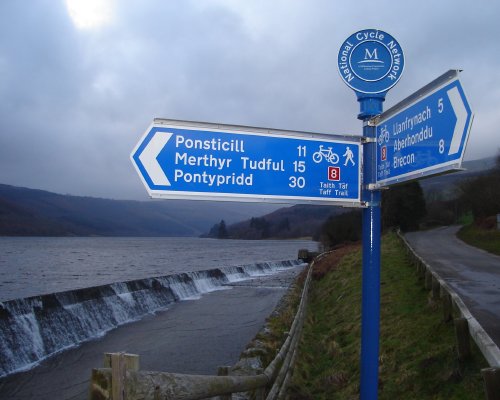
Just as there's a waterway Droitwich Ring (Worcester & B'ham->Droitwich Junction->Droitwich Barge->Severn), there's a cycle route one, too - and they share a fair bit of the way. We did the latter today.
It's a bit unfinished (NCN 45 and NCN 46 both go between Worcester and Droitwich but don't yet connect), though less unfinished than the Droitwich canals - where I'm a bit worried that there still doesn't seem to be any evidence of on-the-ground work.
NCN 45 looks like it could be really lovely. Needs further investigation.
Last A-road in Oxfordshire duly mapped!
If you're on an A or B road where the local council has chosen not to signpost the number (ref), find a railway bridge, and look for the little Network Rail plate saying "If you hit this bridge...". These have the number handily written on them. This is helpful.
Except in Burton, where the local scrubbers have, er, scrubbed out the number.
Even the bridge over the Trent & Mersey near Stenson has one of these: "If you see any waterborne vehicle hitting this bridge..." How much damage do they think a narrowboat travelling at 3mph is going to do?!
Following a comment by Alex Willmer (moreati) on the Radio 4 PM blog, I went into Radio Oxford's studios at lunchtime today to record a few quotes for their Saturday "iPM" programme about maps in general, and OSM and npemap in particular.
Unfortunately, come the finished programme, they didn't use them - choosing instead to go with an interview with Tom Steinberg, who'd said approximately the same things as me but without the OSM/NPE references! Which is a bit exasperating.
According to the iPM blog, however, they were "short on time" and will include the quotes in the podcast version. I'm a bit of a podcastophobe (why listen when you can read something in a quarter of the time?), but would be interested to hear if anyone does download it.
On a brief (cold) spin on the bike last night, I noticed an NCN sticker which wasn't there last time I cycled along that road.
Turns out NCN 54 now runs from somewhere near Burton (Etwall probably, I haven't found the start of this bit yet) to Uttoxeter. The NCN signs are fairly intermittent from Sudbury, and Uttoxeter appears to be the end of route for now. But given that route 54 also runs from Etwall via Derby to Little Eaton, and Etwall via Burton to Lichfield, either it's planned as a Y-shaped fork or a P-like loop.
Fortunately I ended up at Uttoxeter just in time to get the train back. (Back as far as Tutbury & Hatton, anyway, which is fairly near to Burton, and avoids a tedious wait for a connection at Derby.)
Finished off the A428 and the A4071 in Warwickshire on the way home yesterday. Just Nuneaton town centre to do now (joy) and that's another county that'll be A-road complete.
I've got the NPE rectification thing working in Imager code now, so it's super fast. Next task is to get gdal to reproject into spherical Mercator.
Most importantly - vote for Connect2 and help get us some new cycle routes to map!
So I got an HSDPA 3.5G modem for the boat, and I can finally use my G5 again for OSM stuff. Consequently I have spent the last n hours trying to install the Rails port on OS X 10.3 - and, hoorah hoorah, finally succeeding. Much fun. (Incidentally, I now want to kill the author of RMagick.)
More usefully - I can now do some editing in the evenings! I've done one chunk of Burton tonight and will keep ploughing through the notes I'd already taken.
Potlatch now draws casing (a black outline) for any ways with a highway tag, and fills areas for any "circular" ways (same start and end) with certain tags. The colours need some adjusting: thus far it's only key-sensitive, not value-sensitive, and the casing has shown up that some of the highway colours need to be toned down. But it definitely looks better already.
Note that you still select a way, even a filled area, by clicking on the way. Potlatch purposefully doesn't select it if you click on the fill - because that'd make it pretty much impossible to draw, say, roads within an area with a landuse tag.
Trunk and primary
Posted by Richard on 4 November 2007 in English. Last updated on 17 September 2008.Let's nail this one once and for all. mjd - sorry, but Morwen is right.
Ignore the fact that one is a word beginning with "t" and ending with "k", and another begins with "p" and ends with "y". You can call them "elephant" and "K-12" if you like. Really doesn't matter.
OpenStreetMap is an international website. We have to make our tags relevant across national boundaries.
So in the UK, the green-signed A roads are tagged in OSM as "highway=trunk", and the black/white-signed A roads are tagged as "highway=primary". You cannot blindly assume that there is a particular equivalence to any single UK scheme which is your "accepted version of life", especially as that's probably received opinion rather than anything official. You see, there is actually no current UK scheme which uses "primary" and "trunk" in conjunction - just now-outdated (but still copyrighted!) OS maps. Seriously:
| England/Wales government (statutory) | England/Wales government (public-facing usage) | OpenStreetMap | French government
|
| special road | motorway | motorway | autoroute
|
| trunk | strategic | trunk | voie express
|
| class 1 road (primary route network) | primary A road | trunk |
(no such distinction)
|
| other class 1 road | non-primary A road | primary | route nationale (N)
|
| class 2 road | B road | secondary | route departmentale (D)
|
(It's different still in Scotland, where all green-signed primary roads are, since devolution, "statutory trunk". That's certainly not the case in England & Wales. Go figure.)
And the postscript which is actually more important than the rest of it: OSM is a social mapping project. Convention is defined by what other people do. The majority will of regular OSM map editors is that green-signed A roads are tagged "highway=trunk", black/white-signed is "highway=primary". It may seem confusing to you right now, but believe me, there are plenty more confusing things to discover about OSM. :)
I've added about 40 miles or so to OSM's National Cycle Network coverage this weekend, despite - sadly - not having been out on a bike.
First up was NCN 41 south of Gloucester. We got quite a lot of this a couple of weeks back when we went (by car) for a day out in Gloucester, and decided to take an excursion further down the Severn Vale. NCN 41 seemed to follow us wherever we went, so I made a couple of notes. This track, combined with others' mapping, meant that we had the route most of the way to Saul.
South of Slimbridge it was already mapped, but there was a big lacuna between the two, so when we went to Slimbridge this weekend I requested a slight diversion... and lo and behold, that's NCN 41 mostly complete south of Gloucester. (The route in Gloucester itself is still largely unmapped, though.)