SHARCRASH's Comments
| Changeset | When | Comment |
|---|---|---|
| 125355648 | almost 3 years ago | + 1 tracktype updated |
| 125318421 | almost 3 years ago | Oui cette phrase ne parle que des cas pour les feux piétons. Sur JOSM, en faisant la combinaison de tags que j'ai fait, il reconnait clairement les deux en combo. https://snipboard.io/XsIUKp.jpg |
| 125318421 | almost 3 years ago | Pour éviter la redondance, tu as enlevé les feux de route OK, mais pas remis sur le noeud du passage piéton. Je l'ai fait exemple osm.org/node/1473176778 les 2 autres aussi via osm.org/changeset/125318730 |
| 125219714 | almost 3 years ago | + naturals corrected |
| 109792451 | almost 3 years ago | Bonjour! Le fait que vous aiez mis ce chemin osm.org/way/367789686 comme privé pour tous les moyens de transport sur la version 4 me laisse perplexe étant donné qu'il s'agit d'une route résidentielle et qu'il y a un parcours de randonnée officiel. Rien que ces deux indices devraient déjà vous dire qu'il est impossible qu'il soit privé (quelques rares cas vus où le chemin résidentiel est uniquement autorisé pour les riverains). Si une personne à proclamé ce chemin comme privé, c'est un pur mensonge et c'est un abus de bien public. S'il s'agit d'une interdiction pour les véhicules (panneau cercle rouge sur fond blanc), il faut utiliser le tag adéquat. Merci d'avance de bien en prendre considération pour vos futures contributions. Cordialement, |
| 66576723 | almost 3 years ago | Hi! I see you contribute a lot so i think it's worth giving you an advice. Time to time farmer's fields get reshaped, fences as well, and even get changed of type (from specific meadow to more another general crop). I guess they need to adapt to market or expenses, etc... Example: osm.org/way/665640853 and surroundings. It's a pity that all your work has become obsolete and someone has to update. So what i suggest you is to make fields of the same type as big as possible, do not care about smaller plots (it's the same tag and it's very rare that contributors will add the crop to differentiate the field). Landuses farmland and meadow have an obvious and interesting difference worth plotting separately. Cut if there are fences to include it in the landuse area, you won't need to update 2 separated elements, the fences inside with be single elements as well. Careful with 2 adjacent areas having a barrier included in their respective area, the portion adjacent is considered as duplicated, and any renderer will make a bigger line. So in this case plot the barrier separately on the smallest area of the bunch. Hope will be interesting for you. Another point: you had added this area in 2019 January but used 2016 aerial photos. Also for the node osm.org/node/9623914250 from its stream we can see with most recent SPW that the water doesn't pass anymore there since 2018. Your node is very recent though. Do the aerial images get provided that late in BE? Happy mapping! |
| 125152007 | almost 3 years ago | Oh yeah missed the ex railway key! lol Well it was kind of relevant as many people used to take that path. Such a pitty! I think iD programmers did some sort of forbidden editing maneuvers so that beginners do not make unwanted mistakes. One of the reasons i left iD. I moved the cleared further up to the border. |
| 125152007 | almost 3 years ago | Hey D! Thanks for the survey! I was suspecting that the path disappeared but I never had the time to go deeper down in the FR side (also not very motivating to come back uphill). If you joke about the "razed" key prefix, now it's also used as a lifecycle prefix that many use for all kinds of features. Great to know if a feature was lready confirmed. osm.wiki/Lifecycle_prefix ...aaand possibly a weird kind of train with several cyclists following each other. ;) |
| 124929084 | almost 3 years ago | To confirm another way you had deleted at V2, osm.org/way/892073686 this one has been used yesterday... by bicycle! (harder than by foot) https://www.strava.com/activities/7665048952
|
| 125112252 | about 3 years ago | + MP inner integrations |
| 108340280 | about 3 years ago | Bonjour! Attention de ne pas utiliser aveuglément la source BD Topo d'ING, elle n'est pas toujours exacte, voir totalement erronée (idem pour BD Carthage). Exemple sur ce chemin que vous avez tracé osm.org/way/966028650 En superposant avec d'autres sources on peut en déduire que le chemin principal ne prend pas la direction de votre tracé, voir entouré en rouge: https://snipboard.io/cVr7Wh.jpg mais on dirait plutôt la ligne verte que j'ai dessiné. Je pense que la partie rouge est un ancien chemin (peut-être encore existant, utilisé...), il y a à peine une trace qui va en cette direction mais s'arrête à mi chemin. Bien sûr toujours à vérifier sur le terrain. Autre exemple de précision, même chemin vers le NE, le chemin dévie du tracé du Topo. J'espère vous avoir convaincu. Cordialement, |
| 124970348 | about 3 years ago | + surface corrected |
| 124929084 | about 3 years ago | Hi! Thanks for your contributions but i think that a part of your changeset does not reflect reality, you've been too personal in your interpretation or unwillingly erased elements like obvious areas in ofrest visible on 2021 photos. You even deleted ways part of the official Bourscheid hiking route. Here at the end I will give you examples where i had similar case with ways not usable but the official route is still valid, (Geoportail.lu and guide posts still present). From local community advise, when some highways are not usable and no traces are left anymore, please deactivate them with one of the lifecycle prefixes for the key instead of complete deletion. Infos here osm.wiki/Lifecycle_prefix This is useful for a variety of reasons:
Guidelines for ways in nature:
Recent examples i've surveyed, barely usable or/and visible yet i haven 't deleted them:
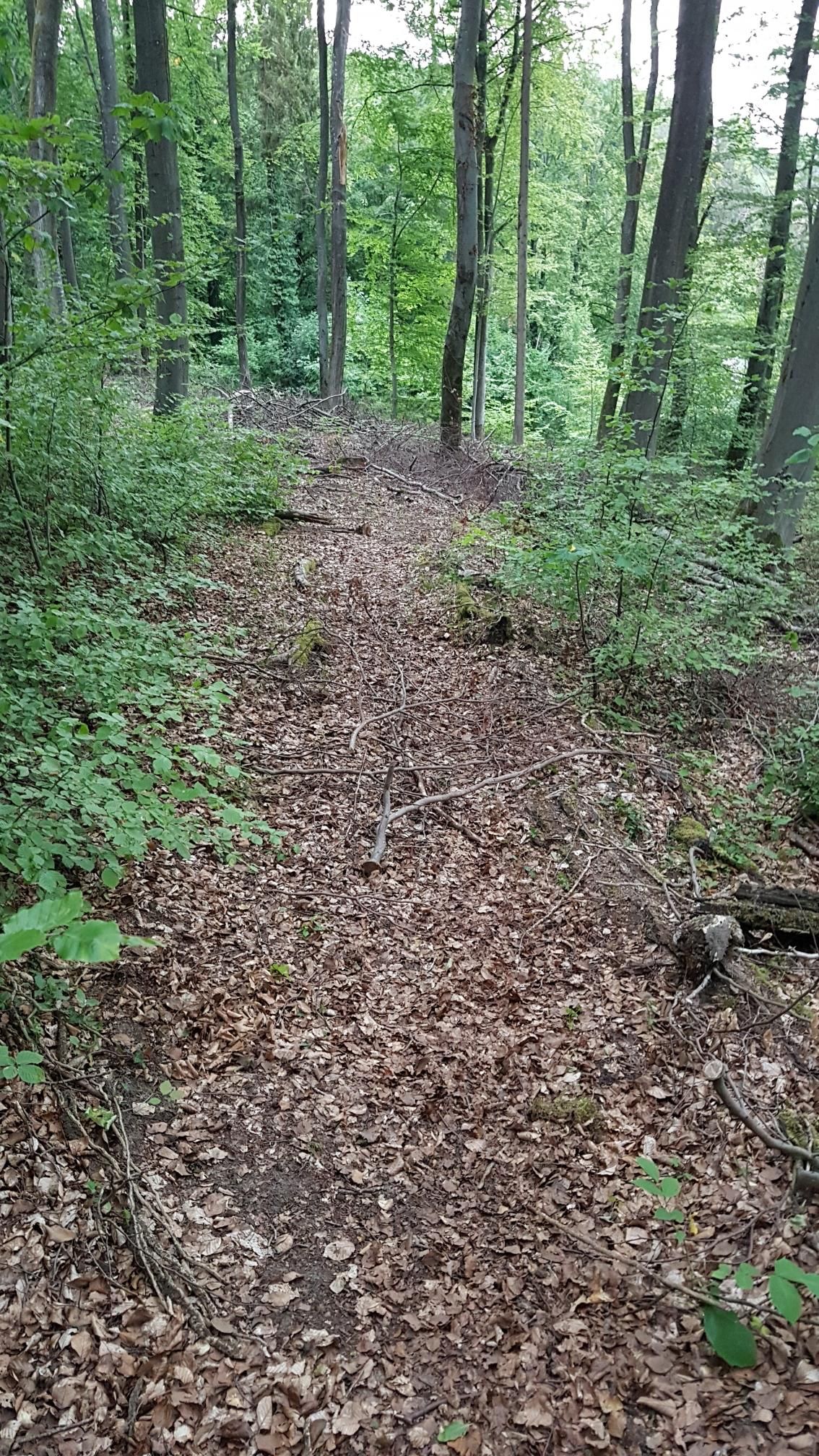
● this way osm.org/way/1022063082 is also part of hiking routes but it's been destroyed by forestry leftovers, see photo https://dgtzuqphqg23d.cloudfront.net/-A-wrbhFAaQBO-u6LfKtgUESLk85AEffBaXvnKNOL7w-1152x2048.jpg I did the restorations and adapted accordingly. |
| 124849699 | about 3 years ago | + cycleways corrected |
| 124740584 | about 3 years ago | + new elements |
| 124700770 | about 3 years ago | + highways split/detailed |
| 124350281 | about 3 years ago | De rien, bonne continuation! |
| 124607858 | about 3 years ago | Urgh yes sorry and thanks! There is so much to correct... Here i've split the areas to make the orchard, so i wanted actually to change the value of landuse and accidently added oneway=shed. I realize now i haven't finished some leftovers because i had seen other things to be corrected. |
| 124184001 | about 3 years ago | Hi! Get ready to talk bout some deep OSM concept... ;) At v5 on this highway osm.org/way/497699528/history you've put cycleway=no whereas there IS a cycle lane on each side up to the traffic lights at least, we clearly see it on the latest aerial photos. On the right side of this highway there is a continuous cycle lane. If you mean that there is no cycle lane past the traffic light on the left side, you shouldn't break the cycling network for such negligible distance when the highway's width enters into account here with the crossroad because highways are represented by virtual vectors which's width is totally relative to the rendering and not reality. Even if you specific the width, it won't solve the issue. So past that traffic light (OK 4m after it but this is really negligible and won't even be visible in the maps because of its resolution) we can consider that we reach the crossroad which is actually represented by the node in OSM whereas we will start to turn a bit before. Again virtually not correct compared to reality yet it is impossible to have this cleared out... unless all highways are rendered from polygons but this will never be easy, too complex, too much work, dare i say never be done world wide. It's a bit like the cycleway=* tag we insert in the highways of roads to render cycle lanes parallel to roads. It is virtual, not the exact position but it works and is way easier and better than to plot all the time a separate cycleway. The real distance is actually negligible. Most importantly, it will be rendered for sure on maps supporting it because important roads are rendered with a very large width to compensate far zoomed out levels and these would certainly hide cycle lanes plotted separately at exact position. For example, like this cycleway at zoom 18 osm.org/#map=18/49.61547/6.17462 , at zoom 17 it is barely visible, zoom 16 oops gone, zoom 15... On CyclOSM's layer map, the Rue de Trèves has cycleway lanes part of the highway yet even visible at zoom out 12! ;) osm.org/way/95751230#map=18/49.61498/6.15874&layers=YD Only with cycleway=tracks far from the main road or/and with very complex shapes it is recommended to plot them as separate ways, like near Esch-sur-Alzette's Gare. I hope i've been enough clear in my description. So please do not insert gaps in the network of elements related to highways for negligible distances. Thanks! :) |
| 123912039 | about 3 years ago | Bonjour! SVP faites attention sur l'éditeur iD lorsque vous désirez couper un chemin qui se superpose avec d'autres éléments, ceux-ci seront également coupés, voir vous créerez des MP à partir de simples polygones. Il faut sélectionner le chemin concerné (ou autre(s) élément(s)) et ensuite le node pour que l'éditeur sache quoi couper. Raccourci x et c'est fait. Vous avez coupé la boucle outer du MP en plusieurs portions
|