OpenStreetMap logo OpenStreetMap

SK53's Diary

Recent diary entries

Comparing natural=heath with an ecological habitat classification for Wales

Posted by SK53 on 26 October 2021 in English. Last updated on 7 November 2021.

A few weeks ago TrekClimbing asked on talk-gb about tagging various types of vegetation. He has documented some of the more problematic ones on the wiki.

The usage of natural=heath in the UK has not been particularly consistent, and his examples confirmed this. The situation is not helped because large swathes of natural=heath were added by a single mapper. Although doubts were expressed at the time, no-one was confident enough to say that such mapping was wrong.

Classic dry heath at South Stack, Anglesey 
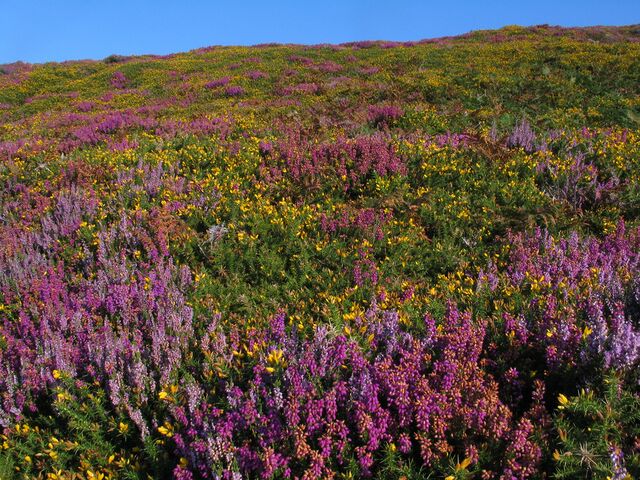
Colourful late summer heath at South Stack

I have been aware that in upland areas of Great Britain natural=heath includes things I would describe differently. Notably these include : upland acid grassland used for rough grazing (mainly of sheep) and blanket bog.

It occurred to me that by comparing OSM data with another source would quantify this impression. Fortunately, a suitable source exists for Wales: Phase 1 habitat data.

See full entry

Location: Betws Garmon, Gwynedd, Wales, United Kingdom

Misuse of sac_scale in the Alps

Posted by SK53 on 8 September 2021 in English.

I was intrigued by the photo on the wiki illustrating the hardest level of the Swiss Alpine Club scale for mountain hiking (known as SAC Scale on OSM and tagged with sac_scale). I couldn’t identify the location and wondered by looking for ways with the tag I could do better.

A quick overpass query revealed widespread misuse of the sac_scale tag for true alpine climbing routes which the Swiss Alpine Club grades using a completely different scale.

A few of the more egregious examples:

  • Geant-Rochfort Arete. A classic high-level snow ridge encompassing a couple of 4000ers. Tagged with highway=path and sac_scale:

Aiguille de Rochefort

Description of route on Hikr.

  • Biancograt of Piz Bernina: apparently trail visibility is horrible, which is a bit of a surprise, because the ridge is rather narrow.

See full entry

Location: Pontresina, Maloja, Grisons, 7504, Switzerland

Everyday Sexism in Street Names

Posted by SK53 on 2 August 2021 in English. Last updated on 11 August 2022.

The other day a new user was asking questions about mapping the new development of the former Royal Engineers Barracks opposite Mill Hill East tube station. I’ll write about their problems with postcodes another time.

However, this prompted me to look at the OSM map of the area, which I knew well in the 1980s. I was a PhD student in Central London (UCL), but a close friend was doing his doctorate at (NIMR](National Institute for Medical Research), and I visited fairly frequently. Over time I got to know other scientists & staff at NIMR, not least because I became an active member of the walking group which was part of the staff club (NIMROD, which still leaves a trace on OSM), but also because of scientific collaborations.

The old NIMR main building

See full entry

Location: Mill Hill, London Borough of Barnet, London, Greater London, England, NW7 1QG, United Kingdom

Another short post on street furniture (you can definitely tell I haven’t got out much in the pandemic as this is the sort of mundane detail I’m focused on at present). Once again these are, as much as anything, notes for myself.

The Ranty Highwayman wrote a great detailed post about the different types of tactile paving and how they should be used in the UK: https://therantyhighwayman.blogspot.com/2015/02/tricky-tactiles.html. It’s very helpful if confused about the various types, and may help to spot incorrect layouts (which can be tagged).

My only additional contribution is to note that in the UK the tactile paving slabs tend to come in a very restricted set of sizes:

  • 40 cm square. The most usual size for both blister & corduroy (hazard warning) paving. There are 6 blisters up & across. I haven’t counted the lines.
  • 45 cm square. A bit less frequent, 7 blisters across (illustrated in the blog post above).
  • larger (perhaps 60cm+). Blister interval possibly bigger than in the previous two examples, 9 blisters a side. I haven’t measure these slabs precisely, but this is an example on Mapillary.

More examples of tactile paving can be found on suppliers’ sites such as this one.

So far, so unbelievably nerdish, but there’s a nifty bit of knowledge from this info which can be applied to mapping much more widely! Knowing the paving slab sizes makes it easy to estimate the width of pedestrian crossings, crossings at dropped kerbs and any pavement/sidewalk where the corduroy hazard slabs are used. This can not only provide a simple way to survey widths without using a tape measure or laser device, but can also assist in estimating widths based on experience.

Location: Old Lenton, Lenton, Nottingham, East Midlands, England, NG7 2FE, United Kingdom

Deterrent Paving & Perforated Kerbs : odd street furniture

Posted by SK53 on 28 July 2021 in English. Last updated on 29 July 2021.

Over time I’ve noticed features appearing on highways & paths which are unusual and which I don’t know how to describe. Often these become much more prevalent. Recently I made an effort to do some reasearch on a couple of these and learnt some useful terminology (documented here so I don’t forget):

  • Deterrent Paving: These is a form of paving which it is difficult to walk or drive over. It is used in a range of situations, but a common use is where a road has been blocked for cars and cycles are allowed through but there has to be some provision for access by emergency services (often labelled “FIRE PATH” in the UK).

Fire Path featuring deterrent paving

There is quite a wide range of different types, some aimed more at stopping pedestrians. The presence of deterrent paving may represent a significant hazard for people with reduced mobility or impaired sight.

See full entry

Location: Forest Fields, Nottingham, East Midlands, England, NG7 6PH, United Kingdom

In March we celebrated the 10th Anniversary of our first pub meeting of local mappers in Nottingham. I’ve written a bit about on-line and in-person meetings held this year, but much more a set of reflections about how the group and its meetings have panned out over the past 10 years.

I hope there are some nuggets of value to others either already running such meetings or contemplating doing so.

Lastly, a big thank you for everyone who has come along over the years, and to Kyle who prompted me to write much of this in the first place.

Location: Castleward, New Normanton, Derby, East Midlands, England, DE1 2FQ, United Kingdom

Attributing OSM is not always positive

Posted by SK53 on 29 January 2021 in English.

If you use the iD editor you are possibly familiar with the MapBox locator layer which appears as one zooms out. There’s a fairly recent post from MapBox about this layer (on Medium).

This transparent layer is also used in other MapBox products and therein lies a problem.

I noticed a tweet complaining about the position of a motorway (or planned motorway) on a local active travel portal for Newport, South Wales. Someone pointed out that the map is credited to OpenStreetMap & MapBox, which caused someone else to say:

“Well now I know why I don’t rely on open source maps …. it’s frustrating as ‘that’ m4 has been the source of plenty of political debate and has been widely regarded as the only way to solve Newport’s congestion”

It took me a while to work out what had happened (with help from russss & trigpoint). There have long been highly controversial proposals for a new route for the M4 motorway around Newport because the current route is prone to congestion. At some stage in Summer 2018 someone mapped one of the proposed routes on OSM (as highway=construction). This incorrect tag was not changed to proposed for several months, but the ways were then removed from OSM when the proposals were dropped in 2019.

Incidentally, it’s not the first tweet complaining about OSM from a cycle campaigner this week.

Location: Nash, Newport, Wales, United Kingdom

Addresses from an old survey

Posted by SK53 on 23 February 2013 in English.

Continuing the recent theme of addressing in diary entries.

Whilst checking something else, I remembered that I’d probably noted some addresses during a small survey in October 2009 (Traces here). I re-located my audio notes and have been able to add using interpolation about 200 addresses.

Quite a few of these were multiple addresses with a single entrance: the availability of Bing aerial photos makes adding these much easier than it would have been 3 years ago. Also the availability of government open data for postcodes means that these addresses are even more useful.

This is a complicated little area, and I am sure there are a number of errors. This is not helped that the 5 tower blocks situated slightly to the North (with perhaps 120 flats in each) are scheduled for demolition. The commercial site labelled “Former MFI Site” is now occupied by the Cornerstone Church and the new building work is nearly complete.

Location: Old Lenton, Lenton, Nottingham, East Midlands, England, NG7 2FE, United Kingdom

twitching

Posted by SK53 on 16 May 2010 in English.

Today I went on a twitch: birding slang for making a specific journey to see a rare/unusual bird. Before I set off I entered the grid co-ordinates from a birding site, and noted that my Garmin OSM map had little detail, so I also carried along my usual OSM kit.

When I returned I discovered that most of the detail had been entered since mid-April, thanks to particular energetic on-the-ground mapping by will7777 in SE Derbyshire, but also lots of use of the recently released Ordnance Survey data. I was able to add a few extra paths, and see enough to add some additional POIs. Of course I travelled back a slightly circuitous route to validate streetnames recently sourced from the OS Data.

What really struck me is how important on-the-ground survey still is.

The OS Data shows a large stretch of woodland (OSM way 57959537) is not actually woodland, but is mostly wetland consisting of large beds of pond sedges. This image shows a powerline (OSM way 59359478) crossing the wetland area, with the wooded area considerably to the N & W of the powerline. This geograph photo shows the same area from a lower viewpoint, and interestingly records the traditional local name, Manner (or Manor) Floods. The powerline on OSM has been sourced from the OS VectorData Map layer. View the same area on Where's the Path. Armchair mappers beware!

And the bird? Images here and videos < href="http://www.bakewellbirder.co.uk/videoscoping/">here (not mine).

Location: West Hallam, Erewash, Derbyshire, East Midlands, England, United Kingdom

Today I was stopped by someone who thought he was lost. He wasn't but was bamboozled by direction instructions from GoogleMaps. Later I looked at his route and realised that the worse was yet to come: Google routes along PSV only roads in the centre of Nottingham. Most of these roads access restrictions have been in force since 2006. Here's a link to an example of such a faulty route.

I then checked the same route in OpenRouteService and on CloudMade. Neither makes Google's execrable error, because of the superior OSM data, but both have their own peculiarities. OpenRouteService is positively averse to using the main route into Nottingham from Derby, and Cloudmade's router routes through a barrier=bollard on its shortest route option.

All three routers suffer generate the following direction in various forms : "12. Turn left at A6200/St Helen's St. Continue to follow St Helen's St" (this from Google). This is St Helen's St, but most locals would call it Canning Circus. I only knew where it was because I collected the street name a few months ago.

All in all it convinced me to take the proposal for storing destination sign information much more seriously now.

Location: The Park, Nottingham, East Midlands, England, United Kingdom

British Bird Fair

Posted by SK53 on 23 August 2009 in English.

I went to the Bird Fair at Rutland Water yesterday. It was a good opportunity to fix a few things in Oakham and start adding more of the Rutland Water Nature Reserve. Amazingly I managed to find 6 new roads to add to the middle of Oakham (2 still to do), although one of them already existed as a ghost untagged way from 2006 by blackadder. I thought there was something missing a while back because the place I catch the bus when I go to the Bird Fair seemed to be missing. Collected a few POIs in the town, and loads on the bus on the way there.

I collected a few details of the bird fair, but the queues for the loos were too long and proximity rather smelly so I failed to waypoint these. I did get to all the hides on the N side of the reserve area: including 2 overlooking a huge new lake (lagoon IV) between Rutland Water and Oakham. I hope I've got enough pictures to do my Naive Triangulation trick to get a more accurate profile of the lake: nothing on Google Earth yet. Also how does one tag poles placed for Osprey nests: man_made=????

I even noted two bits of tactile paving, but haven't tagged them properly yet. They were where the footpath crosses the main road. But quite how anyone who needed tactile paving was going to navigate across the fields, I don't know: particularly the one which was freshly ploughed.

Location: Egleton, Rutland, England, United Kingdom

Mapping Cemeteries

Posted by SK53 on 9 August 2009 in English.

Today I was fixing up a bit of coastline (newish artificial breakwaters) around the Wirral, when I noticed the cemetery where my grandparents are buried. It's one of those large cemeteries where it's hard to find a particular gravestone without some kind of co-ordinate system. Luckily, there is a "Friends of Rake Lane Cemetery", who have a plan of this cemetery on their website. So, I sent a speculative e-mail asking whether we could use this information on OSM, and received a very prompt positive reply. Whilst I consider a sensible tagging scheme, I've temporarily placed POIs with addr:housenumber tags to identify the sectors of the cemetery. I think the sectors really need to be represented as areas.

What use is this? 1. Finding a particular grave in even smallish cemeteries can be difficult, but it is particularly hard in the very large military ones (e.g., Arlington National Cemetery), and war grave cemeteries with thousands of similar gravestones. Maps and plans assist this process. 2. Many cemeteries have significant monuments, or graves of well-known people which may be destinations (Jim Morrison is the obvious example). 3. This is a special case of the problem of navigating in a tract where many individual locations look very similar. The IGN French national mapping agency include sector numbers for some large forests around Paris. These numbers are also marked on the ground at the corner of each sector. 4. OSM tools and renderers could be used for special purpose maps by organisations which care for cemeteries.

Location: Liscard, Wallasey, Wirral, Liverpool City Region, England, CH45 4LA, United Kingdom

Market Rasen and Routing

Posted by SK53 on 21 July 2009 in English.

I was just outside Market Rasen, Lincolnshire on Sunday and have been playing around with looking at OSM routing applications because the route I was given both by Lambertus' routable garmin maps, and OpenRouteServer neglected to use the A46 bypassing Lincoln to the NW. Took me a while to tie it down to one of the ways not being connected to a roundabout: something I missed whilst updating this road by adding dual carriageway sections.

Of the various routers I tried most offered reasonable approximations of a sensible route, but both CloudMade and Routino proposed an utterly infeasible journey time of an hour for a 92 km route. OpenRouteServer's timing was more or less spot-on at 1 hour 20 minutes, although heavy rain and traffic made that estimate pretty optimistic for the return journey.

Cycle routes are still broken on OpenRouteServer: it still creates completely daft routes in Lincolnshire as discovered by Kaerast earlier in the year. Compare this route with the route generated when preference is changed to car.

Too few of the routing pages show the currency of OSM data, and identifying OSM versus routing bugs is difficult because there is little information about the underlying algorithms.

I also managed to do a few minor roads SE of Market Rasen on my way home, and a tiny bit of a new housing estate on the edge of Lincoln. There is a welcome to West Lindsey sign just as one arrives a the by-pass, so the current Lincoln boundary is incorrect.

SK53

Location: 53,334, -0,290

Sets of Eponyms in Street Names

Posted by SK53 on 16 June 2009 in English.

It's rare that OSM mapping makes me laugh, but last night driving home I diverted to collect some additional stubs (and names) for residential roads, and what I found still makes me chuckle now.

I turned into Wembley Road, passed Greaves Close, Byrne Court, Osgood Close, Peters Close, Tambling Close, etc. finally turning into Ramsey Drive. Those of a certain age will instantly recognise these as members of England's one and only winning World Cup squad from 1966. Oddly these are mainly players who did not make the team in the final. Who but sad old gits like me can remember Bobby Tambling? It also places the age of the houses to within a few years after 1966!

Also in the Nottingham area are: the Torvill and Dean estate - named after the eponymous ice dancers and their greatest triumphs, eg., Bolero Drive; and the recently mapped Hempshill Vale estate where all the roads are named from 1960's US astronauts. I hope to discover more of these gems of quirky naming.

Location: Woodthorpe, Arnold, Gedling, Nottinghamshire, East Midlands, England, NG5 4JY, United Kingdom

Gedling, Nottinghamshire

Posted by SK53 on 21 April 2009 in English.

Gedling has long been a big blank on the Nottingham map: it's just off the E edge of the Yahoo Aerial imagery. On Friday I took a couple of buses through the area (on the way to a Chinese meal: relevant POI not yet on map), and grabbed as many street names from the top of the bus (double-decker buses are still good for some things) as I could furtively dictate into my dictaphone. I also managed an hour and a half wandering around one of the more modern developments on the edge of the built-up area. The really good thing was that it enabled me have a much better handle on how much of the old pre-1950s map could be applied to the area, so in addition to the GPS and survey data I've been able to add other streets from those maps.

Unfortunately, I had missed the posts about JOSM with the new API until I'd already done a hefty number of edits. So I've been on tenterhooks all weekend to see if I had to re-do all the work. First attempts failed, but eventually managed to get a one node change uploaded. Further fiddling about using multiple layers, cut-and-paste and hand editing of saved OSM files to set the version=0.5, and I managed to get most of my changes into a new API file. The only bits I've had to redo are the joining of nodes to existing ways, and splitting of existing ways. JOSM needs to give better feedback in the GUI on failed attempts to close a changeset. I haven't tried to do anything with relations: will probably redo these by hand (and not in Potlatch for the moment).

All in all very relieved to get this into the DB, to have personally managed the transition to 0.6, and not to have been the person worrying about why one table wouldn't import (would be nice to have an equivalent of Oracle transportable tablespaces).

Thanks for all the hard work by sysadms.

Location: Woodthorpe, Arnold, Gedling, Nottinghamshire, East Midlands, England, NG5 4JY, United Kingdom

Monterosa Ski Area

Posted by SK53 on 16 April 2009 in English.

Monterosa Ski Area covers the heads of three valleys S of Monte Rosa in the Pennine Alps: Val D'Ayas and Val de Lys in the provice of Val d'Aosta; and Valsesia in Piemonte.

Tracks from a month ago are all loaded and have now been made public. Principal lifts and ski runs are entered. More work needed on POIs, footpaths and roads in Champoluc and Gressoney. Numerous tagging issues encountered (dog free footpaths, nordic ski pistes on roads with a fine of 250 EUR for walking on them during the winter, larch woods (wood=conifer;deciduous), church building reused as a cinema, hotels with distinct facilities (bars, restarurants, night-club) in the same location; chair lift with the two stations in the middle (push-me-push-you)).

Location: Le Lavassey, Ayas, Aosta Valley, 11020, Italy

Bits of Slough

Posted by SK53 on 13 April 2009 in English.

I've been meaning to add the mosque next to the railway in Slough for a while. Whilst doing so I noticed that the large '80s housing estate N of the canal called Rochford Gardens had not been added. Fortunately fairly easy as the developers saved on the effort of finding names for the roads and just used the one name for the whole estate.

Location: Langley, Slough, England, SL3 8DA, United Kingdom

Applying the Karlsruhe schema in Nottingham

Posted by SK53 on 24 January 2009 in English.

I've spent the last couple of days trying to apply the Karlsruhe schema to a small area of Nottingham. Apart from forgetting to record on my dictaphone for a group of long streets all went well. There are plenty of interesting anomalies: odds starting with 3, missing number 13 (i.e., 11 is next to 15), gaps in numbering, extra houses (e.g., 183 and 183a), and even a range of houses with #a numbers interspersed amongst houses which had been more orderly numbered. Two long roads with most houses having names have not yet been done, and I'll have to revisit Harrow Road.

All the ways for a road need to be collected into relations at some stage as well.

Visualise with Osmarender at levels 17 or more. The rendering of house numbers lies over amenities which has meant that I've removed some to improve rendering.

Location: Wollaton Park, Nottingham, East Midlands, England, NG8 1DT, United Kingdom