اوپن سٹریٹ میپ دا لوگو اوپن سٹریٹ میپ

ایہہ «SK53» روزنامچے دے لیکھ

حالیہ روزنامچے دے لیکھ

Do we actually need 860 keys to learn about pubs?

ایہہ ؜30؍؜December ؜2024ء‬ English وچ «SK53» لیکھ چھپیا گیا سی۔

Well over a year ago I extracted all the amenity=pub objects for Great Britain. Nearly 860 keys are used across all the elements. I’ve spent some time delving into these keys, trying to classify them, and hopefully learn a bit about two things: the kinds of information people want to know about pubs; and why synonyms exist for certain keys and tags. I’ve been prompted by SomeoneElse’s list of building tags.

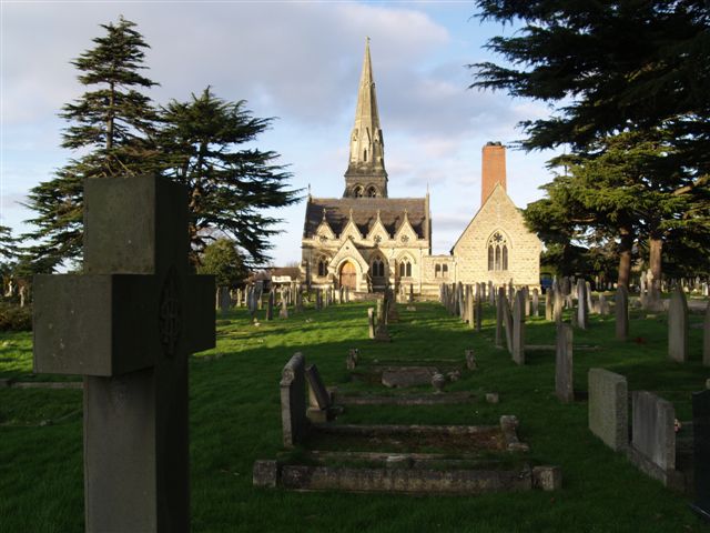
The Top House, Lizard - geograph.org.uk - 903767 A pub which I recently edited on OSM adding real_fire=yes.
See full entry

ستھتی: Landewednack, Cornwall, England, United Kingdom

Mapping Crematoria

ایہہ ؜12؍؜March ؜2024ء‬ English وچ «SK53» لیکھ چھپیا گیا سی۔

A recent discussion on the osm-gb IRC channel was about how to map chapels within crematorium buildings.

Cheltenham Crematorium - geograph.org.uk - 670230

I thought it was worth summarising some of that discussion. These notes pertain to crematoria in England and Wales. I have attended a funeral at that in Geneva, but that was twenty years ago.

One of the difficulties is that most visits to a crematorium are likely to be to attend a funeral service. This is not conducive to any kind of sophisticated micromanaging, but does allow a decent amount of basic observation. In addition I’m not aware of well-developed tagging standards for various features, as may become apparent by looking at some of my examples

In general

See full entry

ستھتی: 51.906, -2.043

Do people map single tennis courts?

ایہہ ؜26؍؜April ؜2023ء‬ English وچ «SK53» لیکھ چھپیا گیا سی۔

In a comment on their recent diary entry publicerination suggested that use of leisure=pitch with sport=tennis was always intended for single tennis courts. I had my doubts given that someone in San Francisco was adding quantity, and I have added pitch:count and there is also a documented tag courts. Were we just the odd mappers out?

Looking east across the tennis courts, Regents Park - geograph.org.uk - 1407669

A relatively quick way to answer this was looking at tennis courts in the UK as I have a 1-2 year old import available for Great Britain. Overpass can also be used to collect the data, but it’s not possible to calculate areas directly. I ran a query which pulled tags, the geometry and the area of each pitch in square metres and saved this first as geojson and then as a csv file.

See full entry

ستھتی: Southfields, London Borough of Wandsworth, London, Greater London, England, SW18 5RL, United Kingdom

Speed limits on highway=primary

ایہہ ؜13؍؜April ؜2023ء‬ English وچ «SK53» لیکھ چھپیا گیا سی۔

For a number of years I have sporadically looked to resolve missing speed limits on major highways (highway=trunk and highway=primary) in the UK. I use a simple Overpass query to find these in a manageable area (usually former regions of England + Wales, Scotland and Northern Ireland.

The other day a discussion arose on IRC about some distinctly English placenames in North Wales. Looking at the area I realised that the A493 had no speed limits added. As both Mapillary and now Bing Streetside imagery are now available in the iD editor, I was able to add limits from Aberdyfi to Tywyn. In the past this nearly always required a survey.

I was going to write about looking at limits elsewhere, but found it easier to add various pictures in a short Mastodon thread.

tl;dr: There’s lots of work everywhere to improve the mapping of maxspeed on highway=primary.

ستھتی: Aberdovey, Gwynedd, Wales, United Kingdom

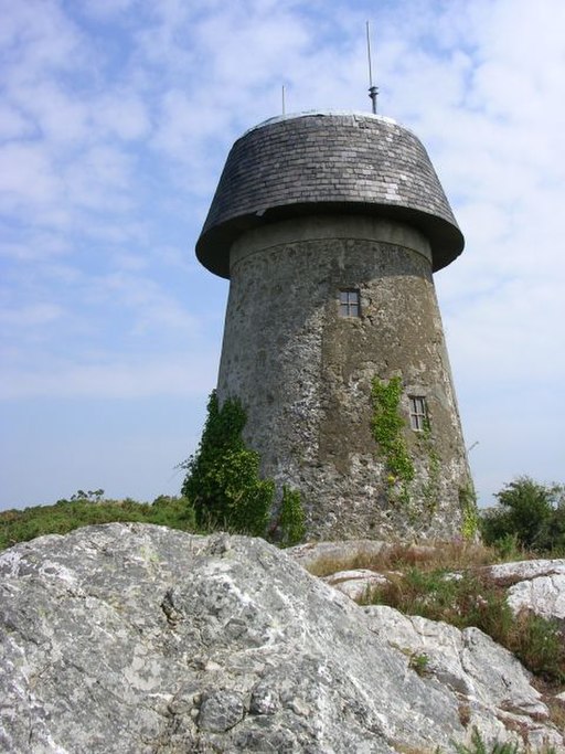
Seen on my (virtual) travels 3. Old Windmills on Anglesey

ایہہ ؜ 6؍؜March ؜2023ء‬ English وچ «SK53» لیکھ چھپیا گیا سی۔

I started drafting this after b-unicycling’s report on her trip to Anglesey as it reminded me that when mapping solar power on the island, I’d noticed a lot of old windmills.

Llangefni windmill

In most of Wales there were abundant sources of water power. So water mills were common before steam engines were available. Many were corn mills, but woollen mills were also common. There was even a tidal mill at Carew.

The only one of these Anglesey windmills I knew about beforehand was the one on Parys Mountain. The stump of the tower is visible from afar. It was used for pumping water out of the copper mines (at one point the largest in the world).

See full entry

ستھتی: Llangefni, Isle of Anglesey, Wales, United Kingdom

Seen on my (virtual) travels 2. Modern Stone Circles

ایہہ ؜28؍؜February ؜2023ء‬ English وچ «SK53» لیکھ چھپیا گیا سی۔

In the UK and Ireland stone circles are amongst the oldest built structures. They are usually mapped with historic=archaeological site, archaelogical_site=megalith. megalith_type=stone_circle. However, mapping in Wales it is soon apparent that there are quite a few modern ones.

Plaza de los Colonos Gaiman

Most are Gorsedd Stones, relics of National Eisteddfodau. However there’s a small covey near the entrance of the show cave at Dan yr Ogof. Most are mapped as monuments or memorials, although I think when the Eisteddfod returns to a site they are used for their original purpose.

See full entry

ستھتی: Rincón del Valle, Gaiman, Municipio de Gaiman, Departamento Gaiman, Chubut Province, Argentina

Steep paths : refinement of approach

ایہہ ؜ 9؍؜January ؜2023ء‬ English وچ «SK53» لیکھ چھپیا گیا سی۔ ایہہ ؜11؍؜January ؜2023ء‬ تے پہلا نواں کرن

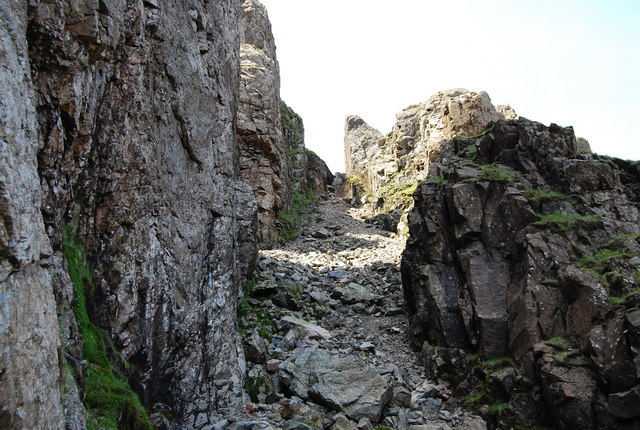
Lord's Rake, Scafell - geograph.org.uk - 1329625 Lord’s Rake: one of the steepest paths marked on OSM in Upper Wasdale

In my last diary I introduced the idea of using elevation models (DEMs), specifically a DTM (terrain model) to find sections of hiking paths on OpenStreetMap which may cause problems for regular hikers. In this sequel I describe a refined approach using a higher quality terrain model and a vertex-based approach to calculating slope angles actually likely to be experienced by walkers.

See full entry

ستھتی: Wasdale, Cumberland, England, United Kingdom

Finding steep paths which may need review

ایہہ ؜ 8؍؜January ؜2023ء‬ English وچ «SK53» لیکھ چھپیا گیا سی۔ ایہہ ؜11؍؜January ؜2023ء‬ تے پہلا نواں کرن

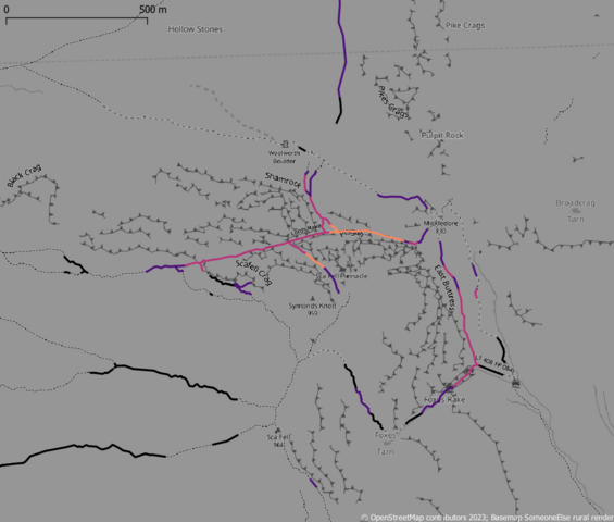
Recently there has been quite prominent press coverage of mountain rescue incidents in the English Lake District involving people using various outdoor activity apps (The Guardian, Grough). It turns out that these incidents involved paths mapped on OpenStreetMap, and have been discussed by the local UK community.

Steep paths on OSM around Scafell (brighter is steeper)

See full entry

ستھتی: Eskdale, Cumberland, England, United Kingdom

Colour-coding OSM data by age in OverpassTurbo

ایہہ ؜14؍؜December ؜2022ء‬ English وچ «SK53» لیکھ چھپیا گیا سی۔

A few days ago i provided an example Overpass query to show buildings with a mapped start_date colour coded by age. This was in response to a query by long-time Latvian contributor richlv. Another user based in Latvia asked on Mastodon if it was also possible to look at data by how long ago since it was edited.

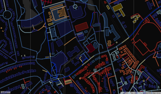
Building & Highways coloured by edit age

This proved to be quite a lot harder than my previous example. The issue is that the “@timestamp” field in Overpass-Turbo is always treated as a string and is never cast to a number or date. This meant that the MapCSS queries have to deal with regular expressions, so I’ve just done the bands in years (“way[@timestamp=~/YYYY.*/]”), as I haven’t experimented with how rich the regexp implementation is for MapCSS. An example of the amended query for roads and buildings in a given bounding box is here.

See full entry

ستھتی: Old Lenton, Lenton, Nottingham, East Midlands, England, NG7 2FE, United Kingdom

Colour-coding buildings by age in Overpass-Turbo

ایہہ ؜ 2؍؜December ؜2022ء‬ English وچ «SK53» لیکھ چھپیا گیا سی۔ ایہہ ؜10؍؜April ؜2024ء‬ تے پہلا نواں کرن

The other day richlv asked on IRC if there was any OSM-based rendering showing the age of buildings. Although I could think of a couple of examples where people have done this, they did not use OSM data (other than the extremely early work.

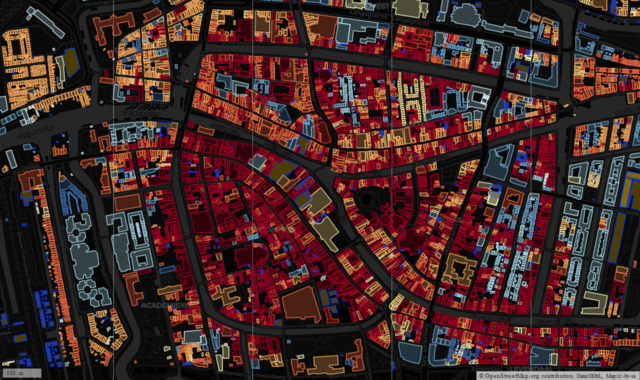
buildings in central Leiden colour coded by building age

I made use of open data of buildings from Portland Oregon to look at clustering, but the inspiration, and awareness that the data existed, came from a MapBox blog post.

A similar approach was taken by Waag who made use of the BAG open data on buildings for the whole of the The Netherlands.

I wondered if it was possible to use MapCSS styling within OverpassTurbo to create a simple way to achieve the same effect. After a bit of experimentation I was able to do this. I used Dutch localities as test areas as all buildings have been imported from BAG and therefore have start_date tags in a consistent format (“yyyy”). I also looked at other places with some buildings (usually those with a heritage protection) have start_date tags.

See full entry

ستھتی: Binnenstad, Leiden, South Holland, Netherlands, 2312 DH, Netherlands

Completing mapping of solar power in Wales

ایہہ ؜12؍؜August ؜2022ء‬ English وچ «SK53» لیکھ چھپیا گیا سی۔

Back in March I was amused to see Amanda tweet that the UK OpenStreetMap community ran a solar power mapping project “several years ago”. This was the theme of the [quarterly project(osm.wiki/UK_2019_Q3_Project:_Solar_Power) in Q3 2019, but the project keeps trucking on.

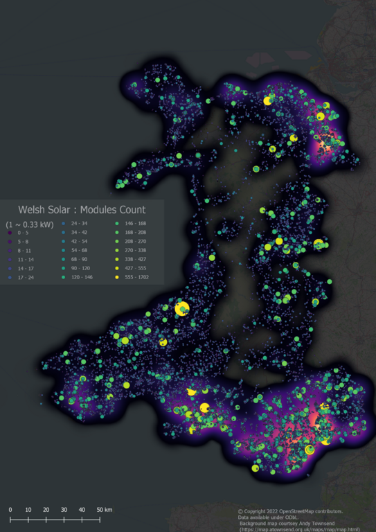
Small-scale Solar Power in Wales; Heat map overlaid with individual solar arrays

All small-scale Solar Power in Wales (i.e., excluding solar farms of more than 1MW capacity)

In the past few days we reached a milestone of having comprehensive solar cover for Wales, one of the constituent countries of the United Kingdom. I think this is the first country to have solar power mapped at such a fine level of detail either on OSM or anywhere else.

The rest of this post discusses aspects of the how & why of this work.

Solar Mapping in the UK

See full entry

ستھتی: Llannon, Carmarthenshire, Wales, United Kingdom

Attention iD users: Bing imagery may be outdated

ایہہ ؜17؍؜June ؜2022ء‬ English وچ «SK53» لیکھ چھپیا گیا سی۔

A few days ago a few mappers in the UK noted that Bing imagery seemed somewhat out-of-date. I noticed it because it appeared not to show recent housing developments until zoomed in at z20. I found a development just outside the village of Llanbedr Dyffryn Clwyd whilst mapping rooftop solar in Denbighshire. My workflow for solar mapping uses Josm. As all the new houses had solar panels I wanted to add the buildings themselves, and I find the way in which imagery can be aligned easier to use in iD than in Josm (particularly as the offset needs cancelling in Josm which does not fit task-based mapping over several thousand square kilometres). So I did it a little crudely in Josm, only to discover that at z20 the imagery was available in iD, so I tidied things up a bit.

I didn’t think much about it until a local mapper in the area commented that Bing seemed a bit behind. This seemed a bit more significant, so I looked at my local university campus which is under continual development and therefore has lots of features which enable one to age imagery. To my consternation the zoom levels down to z19 showed a building which was demolished at least 7 years ago. Whilst looking at this area just now, the z20 imagery appears to be disappearing from cache.

A short distance South of the University is the Nottingham tram line which was well under construction in 2013 because a major bridge was put in place in September of that year. The ‘updated’ Bing imagery now pre-dates the tram development, and any construction work on the Chinese Studies building which opened in January 2013. It does show a new lecture theatre on the main campus which was built post-2009. It therefore appears that the imagery has reverted to a state around 2011 or 2012. Co-incidentally or not, this seems to be the same as ESRI Clarity.

I’ve looked at a couple of other places where I know construction work bridges this period:

See full entry

ستھتی: Maes Famau development, Llanbedr Dyffryn Clwyd, Denbighshire, Wales, LL15 1BF, United Kingdom

Seen on my (virtual) travels: 1. automatic rotary milking parlours

ایہہ ؜23؍؜January ؜2022ء‬ English وچ «SK53» لیکھ چھپیا گیا سی۔

For the past few weeks I’ve been making a concerted effort to map solar panels across rural areas of North & Central Wales (Powys, Gwynedd and Ynys Mon - Anglesey), so far with good results. I’m using a thorough search technique which looks at individual clusters of buildings from Ordnance Survey Open Data (which is complete for Great Britain). This means I see lots of other things which need mapping, but from experience I know it’s important to focus on the specific task. However, I have followed up some of the more striking things, which I plan to report in a series of posts.

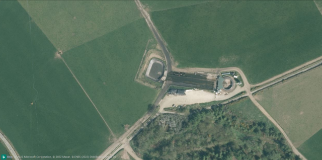
First up was a striking structure in the middle of farmland on the Llyn Peninsula. It was pretty obviously a high-tech milking machine: milking parlour seems a bit quaint for a pretty sophisticated bit of kit.

Bing imagery of Cefnamlwch milking parlour Bing Imagery (close-up view).

See full entry

ستھتی: Buches Cefnamlwch Dairy, Tudweiliog, Gwynedd, Wales, United Kingdom

Mynydd Rhiw : unmapped Welsh heathland

ایہہ ؜18؍؜November ؜2021ء‬ English وچ «SK53» لیکھ چھپیا گیا سی۔

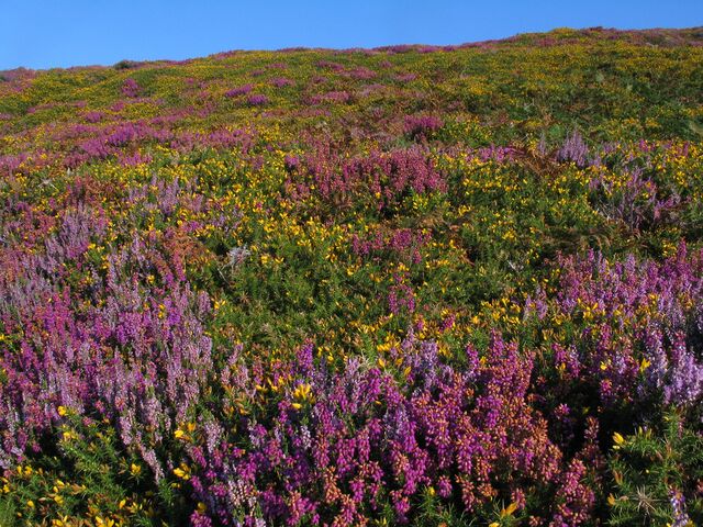
Whilst writing my previous post on Welsh Heaths I discovered that a hill on the Llŷn Peninsula shown as heath in the Phase 1 survey has no landcover mapping on OSM. I walked up Myndydd Rhiw in 2008, just before I started contributing to OSM – so I failed to take enough photos. The weather was not very good that day so I’d opted for a car journey to visit locations on Llŷn rather than brave the rain in Snowdonia. Rhiw was the only place which wasn’t chosen because of personal associations: not only had we holidayed there several times during my childhood, but my great-grandmother’s family come from Llŷn,

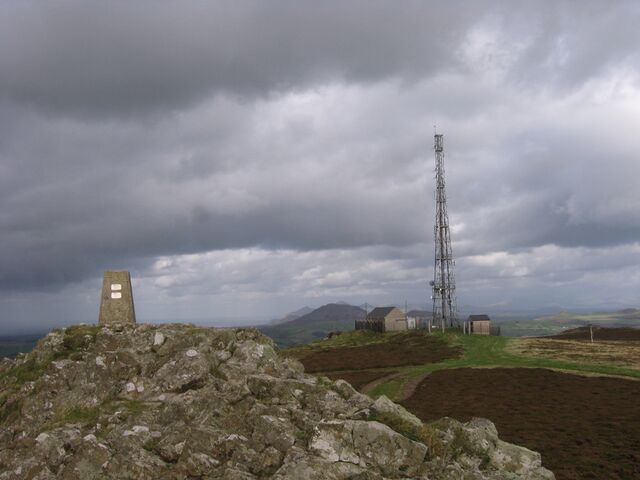
Summit of Mynydd Rhiw Summit of Mynydd Rhiw
See full entry

ستھتی: Aberdaron, Gwynedd, Wales, United Kingdom

Solar power mapping in China: a comparison against ML data

ایہہ ؜13؍؜November ؜2021ء‬ English وچ «SK53» لیکھ چھپیا گیا سی۔

A couple of weeks ago a research group in Oxford published a worldwide dataset of predicted solar power locations in the journal Nature (Kruitwagen et al., Vol. 598, 604-610). There is also a blog post by Lukas Kruitwagen himself on The Conversation.

Apart from the subject’s intrinsic interest, the study is noteworthy because it used machine learning (ML) to make the predictions. The base training dataset came from OpenStreetMap (although the paper makes a single mention and then, incorrectly, adds an “s”). The role of OSM is much better described in The Economist (paywall):

“For this, they turned to OpenStreetMap, an open-source rival to Google Maps in which volunteers had already tagged large numbers of solar plants. But there was little consistency. “Some people had just drawn rough outlines around an entire field,” Dr Kruitwagen says. “Others had gone in and traced the outline of each row of panels separately.” Fixing that involved a great deal of manual labour.”

There is also a New & Views piece in Nature as well. These are usually reserved for articles judged to have particular significance.

The Data

See full entry

ستھتی: Lare, Lhasa, Tibet, China

Comparing natural=heath with an ecological habitat classification for Wales

ایہہ ؜26؍؜October ؜2021ء‬ English وچ «SK53» لیکھ چھپیا گیا سی۔ ایہہ ؜ 7؍؜November ؜2021ء‬ تے پہلا نواں کرن

A few weeks ago TrekClimbing asked on talk-gb about tagging various types of vegetation. He has documented some of the more problematic ones on the wiki.

The usage of natural=heath in the UK has not been particularly consistent, and his examples confirmed this. The situation is not helped because large swathes of natural=heath were added by a single mapper. Although doubts were expressed at the time, no-one was confident enough to say that such mapping was wrong.

Classic dry heath at South Stack, Anglesey Colourful late summer heath at South Stack
I have been aware that in upland areas of Great Britain natural=heath includes things I would describe differently. Notably these include : upland acid grassland used for rough grazing (mainly of sheep) and blanket bog.

It occurred to me that by comparing OSM data with another source would quantify this impression. Fortunately, a suitable source exists for Wales: Phase 1 habitat data.

See full entry

ستھتی: Betws Garmon, Gwynedd, Wales, United Kingdom

Misuse of sac_scale in the Alps

ایہہ ؜ 8؍؜September ؜2021ء‬ English وچ «SK53» لیکھ چھپیا گیا سی۔

I was intrigued by the photo on the wiki illustrating the hardest level of the Swiss Alpine Club scale for mountain hiking (known as SAC Scale on OSM and tagged with sac_scale). I couldn’t identify the location and wondered by looking for ways with the tag I could do better.

A quick overpass query revealed widespread misuse of the sac_scale tag for true alpine climbing routes which the Swiss Alpine Club grades using a completely different scale.

A few of the more egregious examples:

  • Geant-Rochfort Arete. A classic high-level snow ridge encompassing a couple of 4000ers. Tagged with highway=path and sac_scale:

Aiguille de Rochefort

Description of route on Hikr.

  • Biancograt of Piz Bernina: apparently trail visibility is horrible, which is a bit of a surprise, because the ridge is rather narrow.

See full entry

ستھتی: Pontresina, Maloja, Grisons, 7504, Switzerland

Everyday Sexism in Street Names

ایہہ ؜ 2؍؜August ؜2021ء‬ English وچ «SK53» لیکھ چھپیا گیا سی۔ ایہہ ؜11؍؜August ؜2022ء‬ تے پہلا نواں کرن

The other day a new user was asking questions about mapping the new development of the former Royal Engineers Barracks opposite Mill Hill East tube station. I’ll write about their problems with postcodes another time.

However, this prompted me to look at the OSM map of the area, which I knew well in the 1980s. I was a PhD student in Central London (UCL), but a close friend was doing his doctorate at (NIMR](National Institute for Medical Research), and I visited fairly frequently. Over time I got to know other scientists & staff at NIMR, not least because I became an active member of the walking group which was part of the staff club (NIMROD, which still leaves a trace on OSM), but also because of scientific collaborations.

The old NIMR main building

See full entry

ستھتی: Mill Hill, London Borough of Barnet, London, Greater London, England, NW7 1QG, United Kingdom

Tactile Paving in the UK & using it to estimate crossing & sidewalk widths

ایہہ ؜29؍؜July ؜2021ء‬ English وچ «SK53» لیکھ چھپیا گیا سی۔

Another short post on street furniture (you can definitely tell I haven’t got out much in the pandemic as this is the sort of mundane detail I’m focused on at present). Once again these are, as much as anything, notes for myself.

The Ranty Highwayman wrote a great detailed post about the different types of tactile paving and how they should be used in the UK: https://therantyhighwayman.blogspot.com/2015/02/tricky-tactiles.html. It’s very helpful if confused about the various types, and may help to spot incorrect layouts (which can be tagged).

My only additional contribution is to note that in the UK the tactile paving slabs tend to come in a very restricted set of sizes:

  • 40 cm square. The most usual size for both blister & corduroy (hazard warning) paving. There are 6 blisters up & across. I haven’t counted the lines.
  • 45 cm square. A bit less frequent, 7 blisters across (illustrated in the blog post above).
  • larger (perhaps 60cm+). Blister interval possibly bigger than in the previous two examples, 9 blisters a side. I haven’t measure these slabs precisely, but this is an example on Mapillary.

More examples of tactile paving can be found on suppliers’ sites such as this one.

So far, so unbelievably nerdish, but there’s a nifty bit of knowledge from this info which can be applied to mapping much more widely! Knowing the paving slab sizes makes it easy to estimate the width of pedestrian crossings, crossings at dropped kerbs and any pavement/sidewalk where the corduroy hazard slabs are used. This can not only provide a simple way to survey widths without using a tape measure or laser device, but can also assist in estimating widths based on experience.

ستھتی: Old Lenton, Lenton, Nottingham, East Midlands, England, NG7 2FE, United Kingdom

Deterrent Paving & Perforated Kerbs : odd street furniture

ایہہ ؜28؍؜July ؜2021ء‬ English وچ «SK53» لیکھ چھپیا گیا سی۔ ایہہ ؜29؍؜July ؜2021ء‬ تے پہلا نواں کرن

Over time I’ve noticed features appearing on highways & paths which are unusual and which I don’t know how to describe. Often these become much more prevalent. Recently I made an effort to do some reasearch on a couple of these and learnt some useful terminology (documented here so I don’t forget):

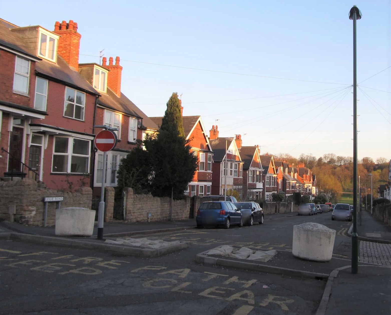
  • Deterrent Paving: These is a form of paving which it is difficult to walk or drive over. It is used in a range of situations, but a common use is where a road has been blocked for cars and cycles are allowed through but there has to be some provision for access by emergency services (often labelled “FIRE PATH” in the UK).

Fire Path featuring deterrent paving

There is quite a wide range of different types, some aimed more at stopping pedestrians. The presence of deterrent paving may represent a significant hazard for people with reduced mobility or impaired sight.

See full entry

ستھتی: Forest Fields, Nottingham, East Midlands, England, NG7 6PH, United Kingdom