Mapping with OSM
Verfasst von SM@Edit am 12. März 2016 in English Zuletzt aktualisiert am 13. März 2016.The Beginning
I started mapping with OSM on 4th March 2016. I used JOSM and used the Bing imagery to get started. “Interesting” and “Exciting” are the two words that best describe my experience so far.
The best part is that OSM is free and my updates become immediately available for the entire world to use!
The JOSM interface is extremely user-friendly and easy-to-use. I could easily update roads, buildings, offices, religious institutions, paddy fields, water bodies and almost anything that I wanted. Different plugins makes the mapping experience a lot easier.
I started my mapping experiments with my native place (Kottayam, Kerala). I found it really easy and enjoyable since I know the place so well. Seeing the OSM getting populated with the details that I upload has been exciting and truly rewarding.
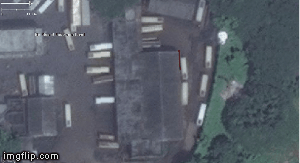
Digitizing Buildings in JOSM
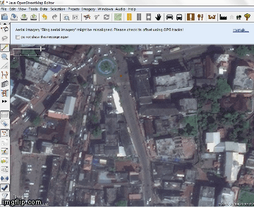
Mapping Roads
Diskussion
Kommentar von Glassman am 12. März 2016 um 22:25 Uhr
Good luck with your continued mapping. If you haven’t joined the talk mail list, I would suggest signing up. Great place to communicate with other mappers.
Clifford
Kommentar von SM@Edit am 13. März 2016 um 04:15 Uhr
Thanks Clifford. I will join the talk mail list.
Sreedhar.
Kommentar von Nakaner am 15. März 2016 um 20:22 Uhr
Usually people claim the opposite. Are you used to use GIS or CAD software or other drawing tools?
Kommentar von SM@Edit am 16. März 2016 um 03:51 Uhr
Yes, I am familiar with ArcGIS, ArcGIS Online, ERDAS Imagine, Micro Station, AutoCAD and some other softwares.