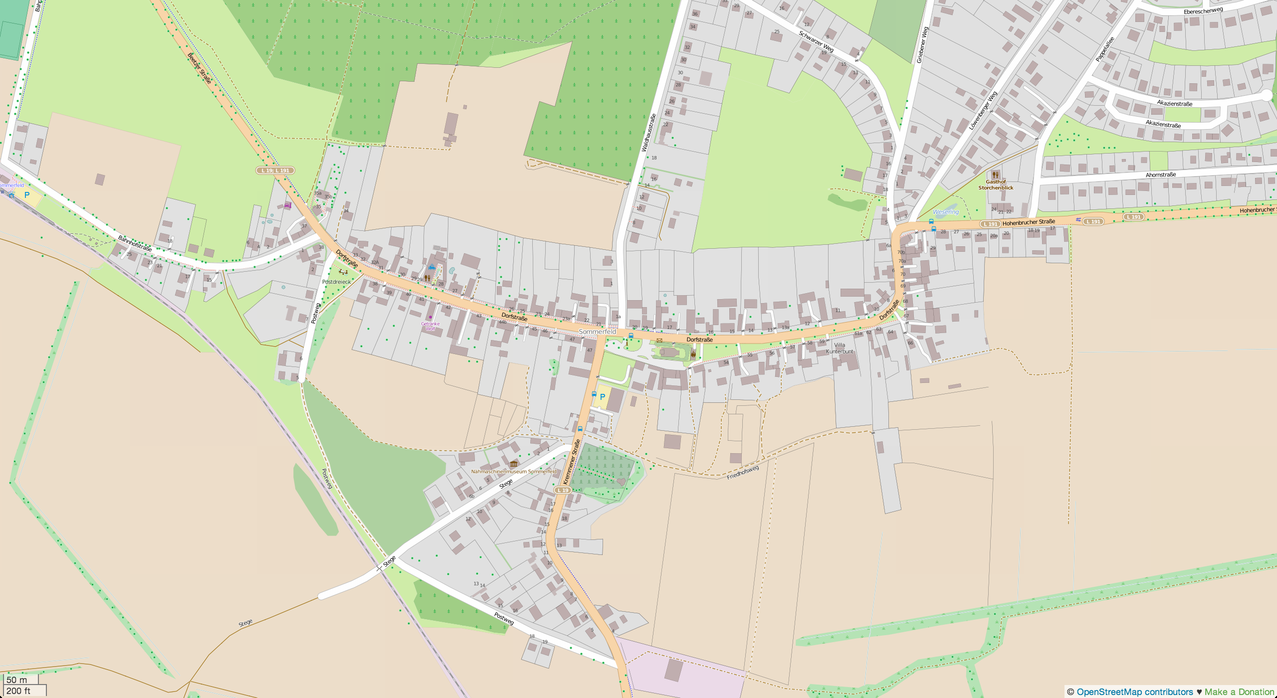
…is the beautiful little village in Brandenburg, Germany named Sommerfeld.
I eventually ran out of ideas what else to map here. Do you have any feedback?
…is the beautiful little village in Brandenburg, Germany named Sommerfeld.
I eventually ran out of ideas what else to map here. Do you have any feedback?
Фекер алышыу
Stalfurтарафынан10 August 2014 cәғәт 21:09көндө ҡаралған
Nice work. May I ask why you did not put the street number on the buildings themselves which already had streetname and town and all that but instead as seperate nodes outside the buildings?
Hedajaтарафынан10 August 2014 cәғәт 21:11көндө ҡаралған
That looks very detailed =) But I Still have an idea left for you: fire hydrants (http://openfiremap.org/) osm.wiki/Tag:emergency%3Dfire_hydrant But at them moment there are other areas that have need of a good mapper. You might try http://tasks.hotosm.org/ and help ceate good maps for humanitarian relief.
mfg Hedaja
gosauseeтарафынан11 August 2014 cәғәт 07:06көндө ҡаралған
Sehr schön! Aber nicht vergessen, wir zeichnen nicht für die Renderer. Sind wirklich alle Hausnummern eingezeichnet? Ahornstraße, Akazienstraße,… Gibt es keine Geschäfte? Hab jetzt nicht in JOSM nachgeschaut: Öffnungszeiten, Url,.. angehängt? Bäume mit Art eingetragen (Buche, Weide, Ahorn,..)
Es gibt hunderte Sachen. Such dir das aus, das dir Spass macht. Viel Erfolg
escadaтарафынан11 August 2014 cәғәт 07:29көндө ҡаралған
3D ? Indoor mapping ?
EdLoachтарафынан11 August 2014 cәғәт 07:45көндө ҡаралған
Bus routes, maybe?
mapper999тарафынан11 August 2014 cәғәт 08:14көндө ҡаралған
Nice work. I like the fences and the 3d tagging.
The roads could have some more details like maxspeed, number of lanes for the “Landesstraßen”, surface and sidewalks (if they are not separated from the road use the sidewalk-key and not separate footways).
Also some access restrictions could be useful. E.g. most of the small service ways seem to be private, not sure about the tracks, they might be restricted to agricultural vehicles.
And if you are interested in public transport you could add the local bus routes and add some more details to the railway line.
You see there’s always more to do :). Have fun!
stephan75тарафынан11 August 2014 cәғәт 12:00көндө ҡаралған
Hallo Shmias,
kennst du schon die verschiedenen Werkzeuge zur Qualitätskontrolle in OSM?
osm.wiki/Qualit%C3%A4tssicherung
Beispielsweise zeigt der OSM-Inspector von geofabrik.de im Address-Layer etliche Punkte zum Verbessern, oder http://keepright.at hat auch einige Treffer. Probiere auch http://qa.poole.ch … um nur einige zu nennen.
Bei Fragen -> deutschsprachiges Unterforum bei http://forum.openstreetmap.org
Gruß, Stephan
Maskulinumтарафынан11 August 2014 cәғәт 13:13көндө ҡаралған
Da ich so viele Zäune sehe, wie wäre es mit dem Zauntyp? osm.wiki/DE:Key:fence_type
Spielplatzgeräte: osm.wiki/DE:Key:playground
Ob die Straßen/Wege (innerorts) nachts beleuchtet sind: osm.wiki/DE:Key:lit oder extrem jede Straßenlampe einzeln
Und vielleicht noch historische Objekte und falls vorhanden Denkmalschutz: Bsp: osm.wiki/DE:Historical_Objects/Karteneigenschaften
Es gibt immer was zu tun :)
Edmund_Humenbergerтарафынан14 August 2014 cәғәт 17:12көндө ҡаралған
Das Ergebnis kann mit hier in 3D betrachten.
Ist sehr schön!
http://demo.f4map.com/#lat=52.8029834&lon=13.0379504&zoom=18&camera.theta=65.054&camera.phi=122.613
Achtung. Braucht WebGL!