[Solved] Mysterious building mapping in Guinean forest
Posted by Socredelir on 31 August 2022 in English. Last updated on 1 September 2022.More than 5 mysterious building sites were found in Kissidougou district, Guinea, where the satellite maps show only forest.
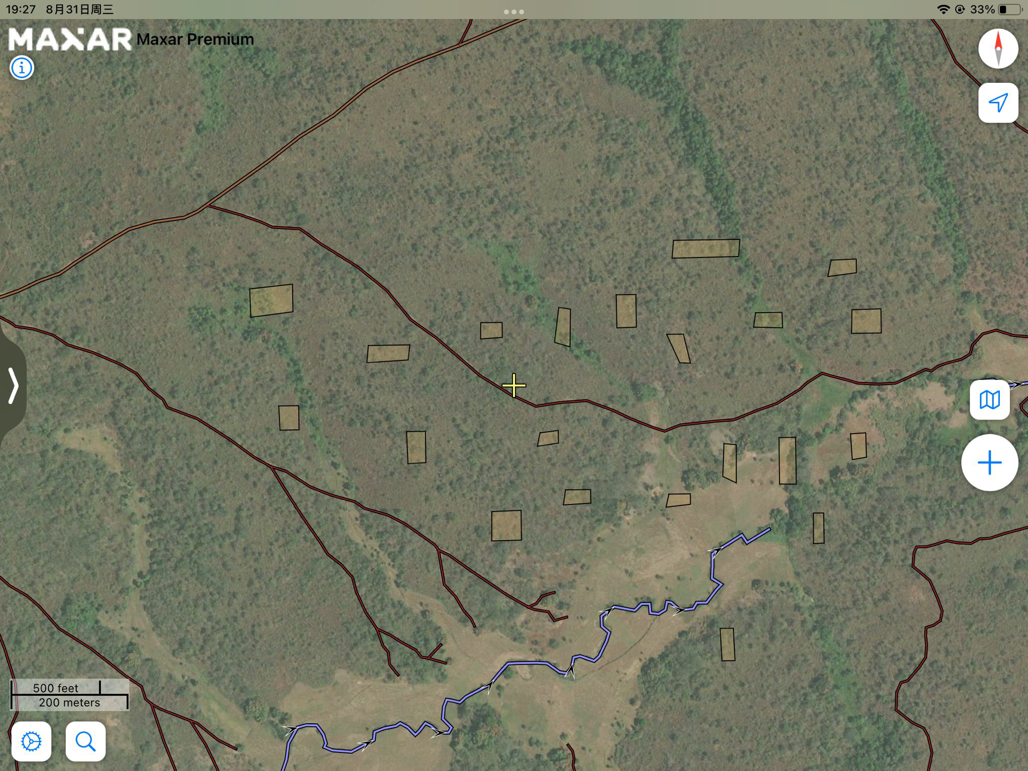
These sites were crowded each with more than 30 buildings, each are squares with size about 100x30 m. It is very clear to be seen when we take a look at the OpenTopomap in the north and the east of Kissidougou city, where these buildings are rendered as a lot of big black spots.
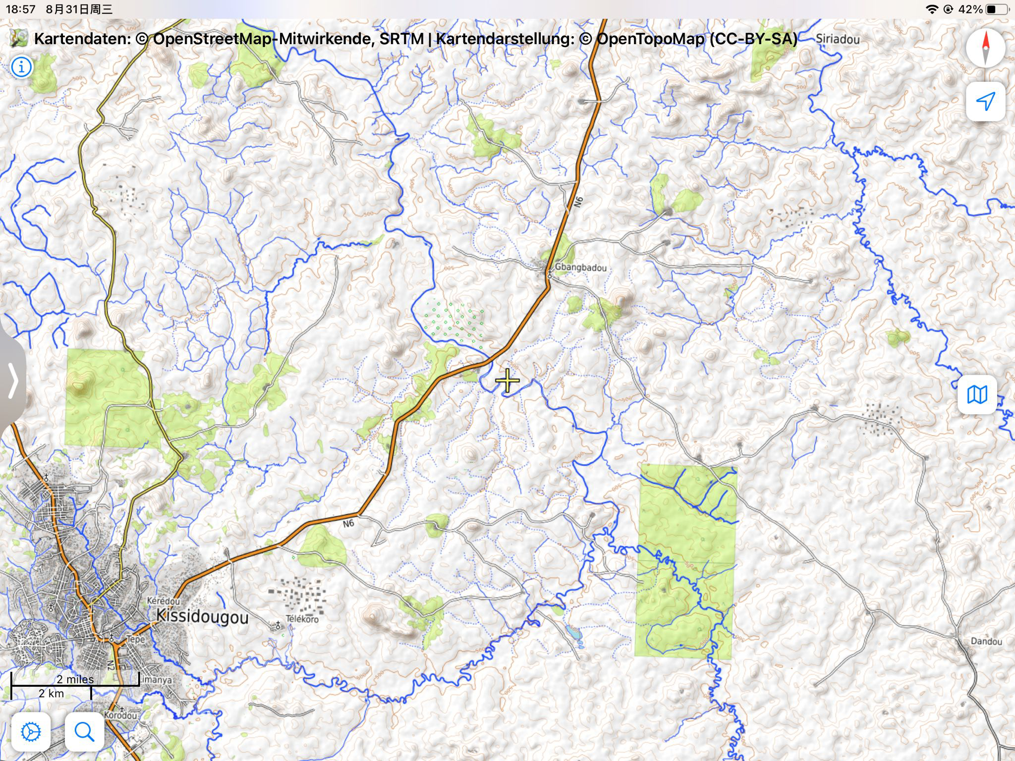
The position marked in the article is only one typical example among them: osm.org/#map=15/9.2019/-10.0495
All these buildings were mapped by the same user, as a part of hotosm project.
Maybe a thorough review of map in Southwestern Guinea is needed.
Update:
Pics added in the diary. All poor mappings have been removed. Thanks to Andy.
Discussion
Comment from SomeoneElse on 31 August 2022 at 21:50
Alas, no review will be possible without a bit more information. The area is somewhere around here, but looking around there for “large buildings where there should be only forest” is much harder without an actual link.
Sometimes new mappers working on HOT projects aren’t as supervised as they should be, and sometimes they add complete rubbish (perhaps “bored georgraphy students” forced to add something to OSM for a school project).
In situations like that I’d suggest commenting on the changesets explaining that OSM is a real map of real places, not somewhere to draw pretend buildings. If that has no effect (and it might not, if they’ve moved on from that geography class) then everything they’ve added will need to be reviewed (and perhaps what their friends on the same class have added too).
If you want help with this please email OSM’s Data Working Group at data@openstreetmap.org .
Best Regards, Andy (from the DWG)
Comment from Socredelir on 31 August 2022 at 22:15
Hello, Andy,
I have attached a relevant position in my article, and I’ll list all such place I found here, but I cannot assure that the list is full, because it’s quite difficult to sort out all such place in a huge forest.
osm.org/#map=16/9.2878/-9.9427 osm.org/#map=16/9.1995/-10.0520 osm.org/#map=16/9.2885/-10.0924 osm.org/#map=16/9.3311/-10.0951 osm.org/#map=15/9.2424/-9.9195
and the woods mapping here is of the same pattern: osm.org/#map=15/9.4165/-9.9835
Maybe a better choice is to check the change log of the relevant user, but I have no tools for doing that. The web version is not so good for a detailed investigation.
Best regards, Vasya
Comment from SomeoneElse on 31 August 2022 at 22:46
Thanks - that does need sorting out (see for example https://nrenner.github.io/achavi/?changeset=105705155 ). I’ll raise a DWG ticket for it and have a look.
Comment from SomeoneElse on 31 August 2022 at 23:13
I’ve tidied that up in osm.org/changeset/125631688 .
Comment from Frans S on 5 September 2022 at 08:30
Hello, Better to just remove them than blaming someone and raise a ticket DWG on ones mappings.
About myself: I am an experienced volunteer validator working for HOTOSM and active on Disaster mappings (validating) like earthquakes, flooding, hurricanes and other disasters. Active for MSF, UN and HOT, all over the world.
I do not know how long you are active on OSM, but in that period (4-5 year ago I guess) we found many weird mappings all over the world, even at sea. That was caused by a bug on JOSM which caused these weird mappings. Those had no relations with the referred changesets. The mappers were just mapping as usual. We (validators at HOTOSM) tried to locate them and removed them. Apparently these were not found.
So it is premature to create a ticket for a changeset that a mapper has done nothing wrong with.
Best regards, Frans Schutz