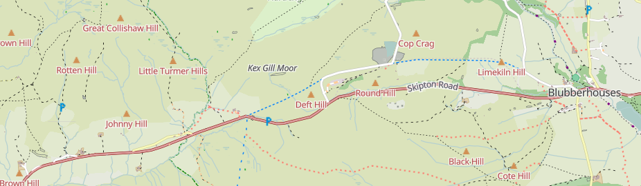
Kex Gill (humorously named the “Côte de Blubberhouses” for a stage of the 2014 Tour de France) is a road in Yorkshire between Harrogate and Skipton. Part of it is gradually sliding down the valley that it is built half-way up the side of and is being rebuilt; it was the access tags on bridleways there that caught my eye in the first place.
What next seemed odd was that there seemed to be no locality for Kex Gill itself, despite it appearing an seemingly every radio traffic bulletin locally for many years. It turns out that there is just this natural=moor and this misnamed area of heathland (I say “misnamed” because there’s really one area of heathland and three localities, there’s no one name with two slashes in it). The heath area appears as expected, but the node doesn’t appear prominently on one of my maps even though I was treating the (deprecated in OSM for vagueness) natural=moor tag as just a place=locality, because we’ve no idea how big it is, and small things only appear at high zooms.
So, why not add the “exact area” of the locality of Kex Gill Moor to OSM? Bluntly, localities such as this don’t have fixed boundaries. Any fixed boundaries that I made up would be wrong because of the “TIFD problem”. A node it will therefore have to remain, but how can we store “how much area does this represent”?
A glance at the imagery and at current-ish OSM-compatible maps from the OS (OS OpenData StreetView and OS OpenMap Local can give us an idea of the actual size - it’s about 6 square kilometers, and that is usually expressed in OSM by the sqkm tag (yes, the wikifiddlers have deprecated that too - but it’s potentially really useful, as we’ll see below).
I added that rough sqkm value to Kex Gill Moor a couple of days ago and changed the vector extract code to use that to decide what vector zoom level it gets written at and also to map that through as a corresponding “way_area” value (so that vector zoom levels >= 14, which all use tiles at zoom level 14, can also work). The result - success!
So what does this have to do with the Pacific Ocean? Well, there are actually a lot of things that don’t really have precise borders and OSM isn’t good at representing them. Take the North Sea as an example - if we believe that relation, the North Sea gets closer to Scotland and Denmark than it does to Norway, despite the country boundaries of all three being similar. Another major problem with trying to maintain “exact” areas for this sort of thing is that they break easily - something that matches a physical feature is easy to verify, but one that is literally invented for OSM is not.
Both of these problems have contributed to the Pacific Ocean being mapped as a place=ocean node (and the North Pacific and South Pacific as place=sea nodes). The Pacific Ocean also has a sqkm value too, so (as per the example above) it’d be easy for someone to use the mechanism above to create a map that shows it to address the issue in this forum thread.
Discussion
Comment from Kai Johnson on 22 July 2025 at 15:13
Thanks for writing up these comments on features that don’t have precise boundaries!
I think about this as well in the context of
natural=desert, which has unfortunately been conflated withnatural=sand. It’s true that there are some sandy deserts, but most of the world’s deserts are rocky rather than sandy. And even deserts have scrub. Sadly, the wiki entry fornatural=desertisn’t helping this.Deserts are important places and have rough boundaries defined by cultural, biological, and geological distinctions. And like oceans or many other large natural features, these boundaries are indistinct and subject to different interpretations.
In spite of the fact that the wiki says
natural=desertapplies only to areas, there are more deserts mapped as nodes than as areas. And I imagine that many of those areas are either conflated withnatural=sandor have issues with the verifiability of the borders.It would be nice to be able to map deserts as nodes with some indication of the size of the area. The
sqkmtag is a possibility, but I see the issues with it as well. Just as it’s hard to get consensus on the boundaries of features like this, it is hard to get consensus on the precise area as well. Does it matter if the Mojave Desert is 65,000 or 130,000 sq km? Maybe that doesn’t make too much difference to a renderer, but it could lead to endless “corrections” to the tag.It seems like mapping large, poorly defined areas is an old problem in OSM. If we do find a solution, it would improve mapping for many different types of features.
Comment from Circeus on 24 July 2025 at 14:58
Adding to kai, tehre’s on top of that the issue of sqkm being essentially a tag-for-the-renderer situation here.
Unlike you I find the combined names a clever solution to this conundrum, which I note your alternative does not actually address otherwise
That being said, borderline situations like this are exactly where a form of tagging for the renderer should really be available…
As to the Pacific Ocean thing, aside from software limitation about maximum size of areas (do these still exist? I thought for water features they didn’t anymore since they were basically moved to a dedicated renderer?) the International Hydrographic Commission has defined specific limits to the oceans, so I really don’t see what prevents the use of those on OSM??