OpenStreetMap logo OpenStreetMap

SomeoneElse's Diary

Recent diary entries

Kex Gill, west of Harrogate

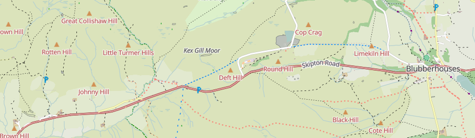
Kex Gill (humorously named the “Côte de Blubberhouses” for a stage of the 2014 Tour de France) is a road in Yorkshire between Harrogate and Skipton. Part of it is gradually sliding down the valley that it is built half-way up the side of and is being rebuilt; it was the access tags on bridleways there that caught my eye in the first place.

See full entry

Location: Blubberhouses, North Yorkshire, York and North Yorkshire, England, United Kingdom

Large and small trees

Posted by SomeoneElse on 31 May 2025 in English. Last updated on 12 June 2025.

Some large and small trees in Woollaton Park

The diameter_crown tag is fairly well used for trees. It’d be nice when showing trees to show larger ones as larger than smaller ones. One challenge is that the values can be a bit hit and miss. There are a couple of sorts of issues there:

One is “obviously silly values from an import gone wrong” like the 289 diameter_crown=width: 2.0; color: green; that have found their way into the database, perhaps by a failed JSON conversion.

Another is “human but not machine readable values” like “4 - 7 m

Another again is implausible values for certain tree types. For example, this is apparently a London Plane that is 5 times wider than it is high. That’s technically possible with a bit of pruning, but unlikely. Much more likely is that the data was not sanity checked before import, and the “diameter” figure here is actually a “circumference”.

In order to work around these issues, when processing the data prior to display I:

See full entry

Location: Selehurst, Lower Beeding, Crabtree, Horsham, West Sussex, England, RH13 6PR, United Kingdom

Lots of people use editors such as iD, Potlatch, Vespucci, GoMap!! etc. for editing. There are entirely sensible reasons for this - I’ll always try and edit relations in Potlatch or iD since for me editing relations there is a much saner experience than in Josm. However, one thing that they miss is Josm’s Validator, which can check for relation errors that other editors can’t. Here’s how to use that to detect problems, and then fix them elsewhere.

I’ve created some test data on the dev server for this, so that I can deliberately create and fix errors. If you want to test with that data on the “dev” server, you’ll need to create an account there and tell Josm to login to that server - or you can just look at the screenshots below.

First, you’ll need to download Josm (I just downloaded the latest .jar file) . Josm’s user interface will be familiar to anyone who used CAD software in the 1980s, but may be less so to others.

Then you’ll need to download some data in the area that you were editing (file / download data / download). So that you can see what is where, it helps to have a background layer - “OpenStreetMap Carto (standard)” will work, or you can use an imagery layer if you prefer. Zoom in to your area of interest, select with the mouse and “download”.

Then click “validate” (on the row at the very bottom right of the screen).

See full entry

Location: Shandonagh, Greenpark ED, The Municipal District of Athlone — Moate, County Westmeath, Leinster, Ireland

Screenshot of the part of the the Southwest Coast Path, with the silly name of South West Coast Path (Section 11: Bude to Crackington Haven)

I maintain a web map style that shows walking and cycling route names. For the cycle routes, it shows the ref. For some time I’ve massaged some of the names so that e.g. National Byway loops show as “NB (loop)” just like on the signage. However, as can be seen from the example above, some hiking route names are a bit convoluted - they’re more like descriptions than names.

For example, osm.org/relation/3971851 is the England Coast Path. Open up the list of members to see the names, which includes such delights as “King Charles III England Coast Path: Southend-on-Sea to Wallasea Island”. I’m pretty sure that it doesn’t say that on the signs there.

See full entry

Location: Filey, North Yorkshire, York and North Yorkshire, England, United Kingdom

Screenshot of the svwd05 map style, showing a Walkers Shortbread shop in Scotland

I created this for my own use, but am sharing it here because it might be useful to other people too. This is the style and there’s a brief readme.

It uses different colours to highlight different map layers. It’s not supposed to look nice; just to show you what is there.

I believe that everything described in the schema is included. If a feature does not appear it might be because:

  • it’s not in the Shortbread schema.
  • it’s in the schema, but is for some reason missing from the OSMF vector tiles.
  • it’s in the tiles, but there’s a bug in this style.

There are lots of features in the first category, and there seem to be a couple in the second. If anyone finds anything in the third category please let me know!

Location: Inverallan, Grantown-on-Spey, Highland, Scotland, PH26 3NS, United Kingdom

Recently, there’s been quite a lot of discussion about the problems with using the tag “highway=path” in the forum. See for example threads here, here, here, here, here, here, here, here, here, here, here, here, here, here, here, here, here, here, here, here and here - and that’s only the last month or so!

It’s not descriptive

On it’s own, “highway=path” doesn’t really say anything other than it’s somehow possible to get from one end to the other. Have a look at the pictures in the wiki - all of those are regularly tagged as “highway=path” in some regions.

There are some really bizarre examples out there. Up the Hillary Step to get to the top of Everest? highway=path. A scuba diving route? highway=path.

While it is possible to add extra tags to say a bit more about the feature being mapped, often this simply isn’t done.

A data consumer (map maker, routing app creator or even just a human deciding whether to go for a walk somewhere) can’t tell what they’re going to find.

The idea is that you can tag a path for pedestrians as “highway=path; foot=designated” and one for cyclists as “highway=path; bicycle=designated”.

The problem here is that “foot” and “bicycle” are “access” tags, and these aren’t always “yes” or “no”. Valid values might be “customers”, “destination”, “permissive” amongst others. If the “foot=designated” on a “highway=path” implies “foot=yes”, what should the tagging be if only customers are allowed?

In countries with some form of allemansrätten (much of Scandinavia, some other places in Europe, including Scotland) this is less of an issue. If you know you can go pretty much anywhere you don’t need to explicitly tag “foot=yes” on everything, and tagging “highway=path; foot=designated” isn’t a problem.

See full entry

Location: Piethorn, Helmsley, North Yorkshire, York and North Yorkshire, England, YO62 5HL, United Kingdom

An sve01 / svwd01 vector map

For some time I’ve been looking after a raster map style that’s designed to be a useful “England and Wales rural pedestrian” map, and also to showcase some of the richness of data that might not be obvious from basic “general” map styles such as the ones on OpenStreetMap.Org.

A goal for some time has been an offline version of that map style. At any useful level of detail that requires different technologies to be used, and the first parts of that - a vector map schema and a web map style - are now available (though not yet available offline).

The online version of that map is available here. It’ll take a couple of seconds to appear.

How vector maps work

See full entry

Location: Erringden, Calderdale, West Yorkshire, England, United Kingdom

Unsuitable for motor vehicles mopeds and cyclists

My previous diary entry looked at the UK section of this OSM wiki page. A commenter there noticed that neither the wiki table nor my analysis covered highway=track (covered here) or highway=service (left for later).

We’ll use the same approach as before. Essentially, that’s this urban area (and this when looking at designation), and this rural area.

It’s useful to look at designation because that tells us what some of the access values should be, and also local authority data about public rights of way such such as visible in this overlay. We’ll therefore ignore ways in OSM with designation set but look to see if any of our examples “should” be designated as a public right of way.

See full entry

Location: Oldstead Mill, Oldstead, North Yorkshire, York and North Yorkshire, England, YO61 4BL, United Kingdom

After reading this forum topic and commenting that the United Kingdom part wasn’t great because it didn’t consider the different rules in England and Wales, Scotland, and Northern Ireland, I wondered “what should the defaults actually be for England and Wales?”.

Of that table, I think that the rows down to living_street are correct, and of the remaining rows the columns across to moped are also correct. I decided to pick a couple of areas I’m familiar with (one urban, one rural) and look for examples in those areas without explicit access tagging. Based on that it should be possible to suggest some sensible defaults.

path

The default of no for everything through to moped is correct, which leaves horse, bicycle and foot.

path, horse, urban

https://overpass-turbo.eu/s/1P4E

https://overpass-turbo.eu/s/1P4G

Mostly these ways are foot=permissive, and there’s no horse signage. In some of the parks horses might be tolerated; elsewhere likely not. This suggests horse=no here.

path, horse, rural

https://overpass-turbo.eu/s/1P4I

https://overpass-turbo.eu/s/1P4H

Mostly these ways are foot=permissive or =yes, and there’s no horse signage. In some of the parks horse access might be =permissive; in most cases not. This suggests horse=no for these as well.

path, bicycle, urban

https://overpass-turbo.eu/s/1P4J

https://overpass-turbo.eu/s/1P4K

Mostly these ways are foot=permissive. In a large number bicycle access is explicitly disallowed.

path, bicycle, rural

https://overpass-turbo.eu/s/1P4L

https://overpass-turbo.eu/s/1P4M

Mostly these ways are foot=permissive or =yes, and on some (but not as many as the urban ones) bicycle access is explicitly disallowed. However there are also some designated “public bridleways” which should be tagged bicycle=yes but are not, perhaps because bicycle access is legal but implausible

path, foot, urban

https://overpass-turbo.eu/s/1P4O

https://overpass-turbo.eu/s/1P4N

See full entry

Location: Kingstone, East Staffordshire, Staffordshire, England, United Kingdom