SomeoneElse's Comments
| Post | When | Comment |
|---|---|---|
| OpenStreetMap Carto release v5.7.0 |
Excellent! The $64,000 question is - are roads without a surface tag assumed to be paved or unpaved? |
|
| Relation 12907666 |
No - trust me - it really doesn’t. If you join everything up into one monster multipolygon it’ll get broken immediately and be a nightmare to fix, as you’ve found. You also may find it a challenge to use iD for this, since it tries to “hide” the geometry from you, which doesn’t always work when something is broken. I find JOSM’s validator invaluable in such cases - you absolutely ought to be using that to check for problems as you go (even if you’re not using JOSM to edit). |
|
| Relation 12907666 | (re mmd’s comment) JOSM’s validator notices that osm.org/way/1126399098 is an inner twice, but that is the least of anyone’s worries trying to edit this… |
|
| Relation 12907666 | Given that it doesn’t have a name, wouldn’t it make sense to split osm.org/relation/12907666 into much smaller wooded areas? That’s going to be a monster to edit! |
|
| How to show paths on a map? | Something else worth mentioning is osm.wiki/United_States/Trail_Access_Project#Suggested_Tagging . When tagging paths such as these, where I differ from what that suggests is mostly as follows:
Aside from those, that page is really useful - including the “Recommendations to land managers” section! Just expecting map producers to tell people where not to go when you have not bothered to sign it yourself is clearly not OK. In the UK one of the biggest relevant landowners is the National Trust, and they’re actually pretty good about this sort of thing. ** The actual suggestion is that “an official path” should be tagged as “highway=path;name=Name of Trail”. Obviously there will be examples where the name of the path IS the same as the name of a route running over it, but even from my experience in the Western US, it’s rare. |
|
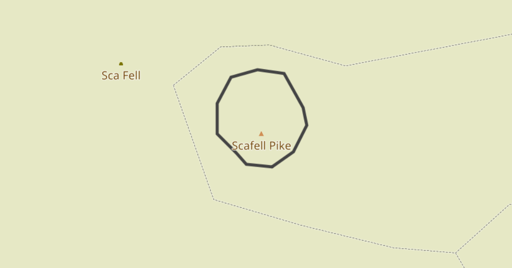
| How to show paths on a map? | Zoom in a bit and you can see what is happening:
The “Sca Fell” name is from the trig point, and the “Scafell Pike” name (which is obscured) and elevation (which isn’t) is from the peak. For “proper mountain-looking mountains” this side of Dover you probably want something like Errigal though… |
|
| Is this how gen Z works? They talk through hashtags right? |
At a guess, I’d say “markdown”. See https://kramdown.gettalong.org/quickref.html . |
|
| Reimagining the OSM User Profile | @MatthiasMatthias In what I wrote above I tried to suggest a way forward so that the diarist here can see the ideas described here realised. OSM does not have dozens of people with no ideas but lots of free time just waiting for people with ideas to come forward that they can implement. It actually has the reverse - lots of people with ideas about how things should work, but reletively few people in a position to implement them. To say otherwise is actually grossly unfair on people writing diary entries such as this - it encourages them to think that “software is written in powerpoint”**. In practice software (of any sort) gets written because someone somewhere wants to do it or because someone is paying them to do it - but the person doing the writing has to know how to write software. The good news is that with OSM everything you need to know is out in the open - for almost all OSM software the source is available and there are plenty of places where people who want to learn how to implement something can ask and get help about how to do it. ** I actually once did work for someone who seemed to think that - he once claimed that he had “demoed XYZ feature to a customer” when what he actually meant was created some slides of what it might look like. |
|
| Reimagining the OSM User Profile | (commenting here because this seems a more appropriate place https://github.com/openstreetmap/openstreetmap-website/issues/3785 ) This, and https://github.com/openstreetmap/openstreetmap-website/issues/3785, seem to be:
Normally, the way that development around OSM happens is that someone implements a small part of what they are suggesting, sometimes independently to the main site. That is then discussed with the people who look after the main site, because obviously there are lots of issues that they are aware of that “normal” people may not be (how it is integrated with the management software used, for example; legal issues such as GDPR, etc.). That discussion often takes the place of actual suggested code changes on github. How close are you to actually being able to contribute code - either as a working proof of concept project external to osm.org, or as suggested changes to the main website itself? Unfortunately, just providing pictures of what something might look like without any idea of how it could be implemented (or even if it is at all feasible) does not get us any closer to seeing your vision realised, but an implementation of something would. Do you have any actual development experience? I’m guessing based on github possibly not, and if that’s the case I’d suggest that in the short term you concentrate on how to deliver a small part of your vision yourself. You’ll no doubt need to learn some new tools and solve some problems on the way, but that’ll help you answer the questions that people are bound to ask (e.g. “how would you avoid X being a problem”). |
|
| Markdown Test | (obviously this is to some extent a rhetorical question to test markdown but) I suspect that the answer is that OpenStreetMap might be more “social” than you realise. For local groups, try looking on https://openstreetmap.community/ where you are. |
|
| Request to add Republic of Molossia |
No it isn’t.
It’s already there, added as what it is - a tourist attraction. |
|
| On taggings and stylings | It’s great that you’re experimenting with creating your own local, region-specific, map to show local, region-specific, map features! The “challenge” with the various vector tile approaches is that (a) there are lots of them and (b) none of them are in the same state of maturity as the software stack that is behind the tiles that you see on OSM’s “standard” style. People are doing lots of excellent work here (in no particular order see e.g. here, here and here) but none of the open ones are as feature-rich, flexible, supported and well-documented yet as e.g. osm2pgsql / mapnik / renderd / mod_tile / apache yet. If you’re not worried about vendor lock-in then you have lots of other options too, limited only by your wallet. If you’re happy to create the same sort of map that you see as the “standard” style at osm.org what you need to do is well documented. If you’d like to change that style to show other things there’s help showing how to do that as well. In terms of the cost of running a server, one (in Europe) for Britain and Ireland currently costs me around €20 a month. Indonesia in OSM is a bit smaller than that, so you might get away with €16 a month or so. What I don’t know is if a server in Europe is too far away to be useful, or if there are equivalent providers at a similar cost more local to you. |
|
| [Solved] Mysterious building mapping in Guinean forest | I’ve tidied that up in osm.org/changeset/125631688 . |
|
| [Solved] Mysterious building mapping in Guinean forest | Thanks - that does need sorting out (see for example https://nrenner.github.io/achavi/?changeset=105705155 ). I’ll raise a DWG ticket for it and have a look. |
|
| [Solved] Mysterious building mapping in Guinean forest | Alas, no review will be possible without a bit more information. The area is somewhere around here, but looking around there for “large buildings where there should be only forest” is much harder without an actual link. Sometimes new mappers working on HOT projects aren’t as supervised as they should be, and sometimes they add complete rubbish (perhaps “bored georgraphy students” forced to add something to OSM for a school project). In situations like that I’d suggest commenting on the changesets explaining that OSM is a real map of real places, not somewhere to draw pretend buildings. If that has no effect (and it might not, if they’ve moved on from that geography class) then everything they’ve added will need to be reviewed (and perhaps what their friends on the same class have added too). If you want help with this please email OSM’s Data Working Group at data@openstreetmap.org . Best Regards, Andy (from the DWG) |
|
| tidying stiles | Thanks for tidying these up! I had a look at these in UK and Ireland a while ago (using values from https://taginfo.geofabrik.de/europe/britain-and-ireland/keys/stile#values ) These (at least) are definitely valid distinct values: Other names for those 4 seem to be: Typos and others: Personally I think I’ve mapped osm.wiki/Talk:Tag:barrier%3Dstile#stile=insulated_section/_hose_etc as gates rather than stiles - and I’ve tended to not map them if they’re obviously temporary / movable (often the case for cattle, less so for horses). |
|
| Apple Data Team #ADT multiplying Nodes on Coastlines | I’m not sure I understand “it is painful for other mappers to connect their own adjacent ways to these nodes”? I thought that in most editors it was possible to easily add something following another way? Also, I don’t think that [the one example that I looked at] was particularly overnoded - Had I been tracing something around osm.org/node/8114873377 , I might have used more, rather than fewer, nodes. Andy (not in any way connected to Apple’s Data Team) |
|
| Can’t read the language | If you mean “when I browse the map somewhere such as osm.org/#map=6/30.126/110.149 I can’t read the placenames, because I don’t understand Chines script”, may I suggest that you try one of the 2 map styles of the 6 (such as osm.org/#map=6/30.126/110.149&layers=C ) which also include English names? If you mean something else, you’ll need to explain in a bit more detail… |
|
| OpenStreetMap Carto release v5.6.0 |
No - it really doesn’t. I’ve just sat watching it for 10 minutes between “INFO:root:Checking table water_polygons” and “INFO:root: Download complete (810110834 bytes)”. There were no on-screen updates, no progress bar. The previous version of the script made curl’s progress bar visible on-screen. |
|
| OpenStreetMap Carto release v5.6.0 | One other question - what operating systems are supported (expecially with regard to the fonts change) and which have explicitly been tested? |