fortera_au, I guess you don’t know about three versions of the schema, about how the one we use is practically unusable for apps, and the differences in mapping between countries :) Public transport is indeed the most complex thing to map.
I know about PTv2, if you’ve got any links you can send my way I’d definitely appreciate any extra info! I’ve got the AU tagging info for public transport already at least.
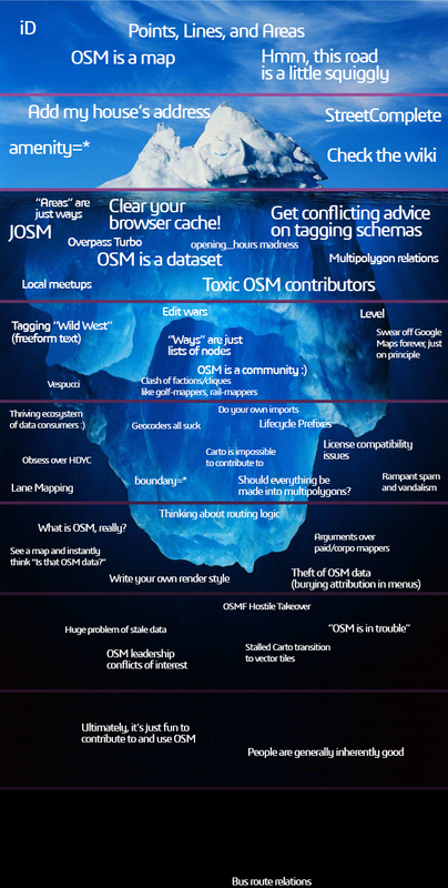
Many thanks, I did actually laugh out loud at this one. Hope to see this as merch at SOTM. (If I can make a suggestion, I think “Level” should read “Level0”.)
The last one caught me off guard. “Attend to OSM meetings via IRC” is missing though (I once went to the OSM IRC channel and just spectated a meeting where some users talk briefly about what they had planned and achieved for the week and then went out for a couple beers)
OSM hostile takeover also caught my curiosity and… now I know…

토론
2024년 1월 11일 19:02에 Zkir님의 의견
:)
2024년 1월 11일 23:11에 Pieter Vander Vennet님의 의견
Hilarious! I love it. The bottom one really caught me of guard. Also, I can check like 80% of the things you mention. :)
Do you have a mastodon-account? It would be great to post it there as well. If you don’t have one, can I repost it there (and on lemmy?)
2024년 1월 11일 23:27에 Xvtn님의 의견
Pieter, glad you enjoyed it. Great idea - I do have a budding Mastodon account. I’ll make a higher resolution image and post it!
2024년 1월 12일 01:16에 Pieter Vander Vennet님의 의견
You can validate your OSM-profile on Mastodon BTW:
Add a link to your mastodon as
<a href='https://yourmastodon/@account' rel='me'>My Mastodon account</a>in your profile settings, under ‘Extra fields’, add link to your OSM-profile in the right column (thus: osm.org/user/Xvtn), you’ll get a green dot
For example: https://en.osm.town/@pietervdvn
2024년 1월 12일 08:43에 Zverik님의 의견
As a person living under all the layers and a few layers down, I’d rotate this 180° :)
2024년 1월 12일 08:56에 fortera_au님의 의견
Considering I’ve added some bus routes in my state and am wanting to add them all, I’ve clearly dived straight to the bottom!
2024년 1월 12일 09:03에 Zverik님의 의견
fortera_au, I guess you don’t know about three versions of the schema, about how the one we use is practically unusable for apps, and the differences in mapping between countries :) Public transport is indeed the most complex thing to map.
2024년 1월 12일 09:05에 fortera_au님의 의견
I know about PTv2, if you’ve got any links you can send my way I’d definitely appreciate any extra info! I’ve got the AU tagging info for public transport already at least.
2024년 1월 12일 09:31에 Lejun님의 의견
AFAIK there’re not 3 but 4. I wrote up some notes about them in french.
2024년 1월 12일 09:41에 silversurfer83님의 의견
Good one 😄
2024년 1월 12일 09:56에 Andy Allan님의 의견
Fantastic!
2024년 1월 12일 11:09에 Danysan95님의 의견
fantastic 😂
2024년 1월 12일 13:59에 NorthCrab님의 의견
Btw, I tried to make mapping of bus relations a little bit more fun: https://github.com/Zaczero/osm-relatify 😉
2024년 1월 12일 14:21에 Yury Yatsynovich님의 의견
Good one!:)
2024년 1월 12일 15:29에 paulbrunner님의 의견
Many thanks, I did actually laugh out loud at this one. Hope to see this as merch at SOTM. (If I can make a suggestion, I think “Level” should read “Level0”.)
2024년 1월 12일 18:51에 amapanda ᚛ᚐᚋᚐᚅᚇᚐ᚜ 🏳️⚧️님의 의견
😂😂😂😂
2024년 1월 13일 13:03에 mboeringa님의 의견
Well, since we are already in climate meltdown, it seems there is more than one OSM problem that will spontaneously resolve itself in the near future…
Just ensure your man_made=dike / embankment=dyke / embankment=yes / waterway=dam / barrier=coupure is high enough for when the flood waters come… 😉
2024년 1월 13일 13:29에 mboeringa님의 의견
man_made=dyke / height=current_height + 217ft perhaps? 😉
https://www.nationalgeographic.co.uk/environment-and-conservation/2017/11/what-the-world-would-look-like-if-all-the-ice-melted
2024년 1월 13일 14:02에 Richard님의 의견
That’s so good.
2024년 1월 13일 19:18에 ivaldonm님의 의견
Achei engraçado os colaboradores tóxicos estarem na parte do JOSM. Nas interações que tive com a maioria deles verifiquei isso prospera.
2024년 1월 21일 15:12에 Stereo님의 의견
This is so good.
2024년 1월 22일 09:54에 Mateusz Konieczny님의 의견
I quite like it, especially two lowest levels :)
2024년 1월 23일 11:06에 Misac Tiba님의 의견
The last one caught me off guard. “Attend to OSM meetings via IRC” is missing though (I once went to the OSM IRC channel and just spectated a meeting where some users talk briefly about what they had planned and achieved for the week and then went out for a couple beers)
OSM hostile takeover also caught my curiosity and… now I know…
2024년 2월 11일 14:05에 Koreller님의 의견
Thanks for this image !
2025년 4월 11일 12:40에 LouisXIV님의 의견
Excellent! I just discovered this iceberg today, here are a few suggestions for an update: