On a couple of occasions I’ve noticed what I call an “eye” effect when plotting a GPS track through trees. The first time, I walked back and forth along an east-west trail and when I passed a certain spot the traces opened up, then closed again so they were superimposed, leaving a kind of eye shape in the middle. I thought it might make sense if the trees were particularly dense, but they were not - in fact, there was a small open area over a pond to the south.
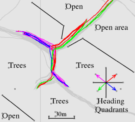
Recently I noticed a similar effect in another area, this time on a north-south section of trail. Actually walking the trail, it was quite obvious that the tracks were superimposed and then opened up for a distance then became superimposed again. I made several passes and then plotted the tracks to show the direction of travel - it seems that the position of the tracks depends which way I was going. Again, there was a slightly open area to the north - the main track in along the centre of a wooded area running SE-NW, with two small paths leading north and south. The northerly one is through a less densely wooded area. The trees are deciduous, silver birch or similar, about 80ft tall with few lower branches, spaced on average maybe 15ft apart. It’s not a particulary dense wood - not at all dark and you can easily see sky between the tree tops. I tried recording more tracks later in the day, and the next day at a different time. The tracks don’t align perfectly between each group, but the eye effect is there on each occasion. These tracks are from a Garmin GLO on my hat (taking Dieterdreist’s advice). The earlier one (not shown) was with the builtin GPS in my N810 tablet)
I wondered if anyone else had seen this effect, or knew what caused it. I’m a bit perplexed by the effect of direction of travel - surely I’m not seeing a doppler effect at walking speed, and anyway GPS sets are designed to be used when moving.
Discussion
Comment from Hendric Stattmann on 3 November 2014 at 19:57
Hello!
I can confirm having seen a similar effect, even though I did not systematically evaluate it like you did. My highly speculative explanation attempt is that the GPS device appears to unknowingly add some kind of “inertia” to the track, so that when you change direction, it takes a little moment for the device to account for this change and this creates a little deviation from the real location. I have had my fair share of frustration when trying to map zig-zag paths in forest areas…
In general, your tracks still look as precise as could be expected from a GPS device.
Kind regards, Hendric
Comment from kucai on 4 November 2014 at 01:11
You mean it might have a track “prediction” algorithm?
Comment from aseerel4c26 on 4 November 2014 at 18:36
@kucai, Hendric: inertia would help to smooth the track, reducing the random errors of GPS. If devices really apply inertia therefore is not known to me. Apparently Kalman filters are used (which may have inertial properties, if I understand correctly). See http://www.garmin.com/en-US/company/leadership/min-kao/ and https://en.wikipedia.org/wiki/Kalman_filter .
Comment from Warin61 on 5 November 2014 at 06:29
Normal thing, nothing unusual.
GPS specific; When you go into a tunnel some GPSes assume you travel in a straight line to the next place where they get a signal.
All GPSes when they loose a single satellite signal can ‘jump’ in sensed location - even if the real location has not changed. Simply the single satellite signal sullied a correction signal .. that is lacking when that satellite is lost.
You may have a reflected signal off some local object that distorts the GPS signal in such a way as to off set the calculated location. Expensive survey GPS systems exclude signals below 10 degrees above the horizon. They even have options to do more, thus allowing for local conditions.
Some GPSes will display the expected ‘error’ under the present reception conditions .. this is usually the mathematical standard deviation (1 sigma). I’d expect that your GPS has a 10 meter expected ‘error’. Most of the time it is less than that .. but some of the time it gets up towards that figure, even exceeding it for a little of the time. Thus your tracks are ‘about right’. People who have access to many GPS tracks of the same thing apply maths to get a good single track.