
Tagging methods when the entire area is a crosswalk(영역 전체가 건널목인 경우)
adreamy 于 2023年七月 6日 以 English 发布 最后一次更新于2023年七月16日。Nowadays, crosswalks are often drawn in an X shape to accommodate pedestrians.
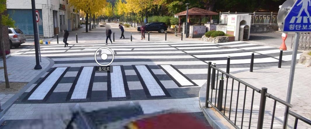
And here we have an entire area designated as a crosswalk.
How do you tag them in these cases?
Also, there’s not even a traffic light here at all, so I want to designate this as a pedestrian zone.
What are your views?
After considering different cases and situations and comparing the OSM wiki, I concluded that the ‘area:highway=pedestrian’ tag is the most similar.
The rationale is that…
- There are too many different pedestrian directions.(건널 수 있는 방향점이 매우 많다.)
- There are no traffic lights and pedestrians can enter at any time.(교통 신호등이 없고 보행자가 언제든지 길로 들어설 수 있다.)
- These attributes are very similar to ‘highway=pedestrian’.
For reference, I’m adding a discussion from the OSM forum.
keywords : 건널목 횡단보도 보행자지역 보행자 crosswalk crossing scramble pedestrian
讨论
TrickyFoxy 于 2023年07月15日 20:16 的评论
«area:highway=pedestrian 1»
What does 1 mean?
adreamy 于 2023年07月16日 09:41 的评论
@TrickyFoxy Oh, sorry. A simple mistake. XD
TheSwavu 于 2023年07月16日 09:59 的评论
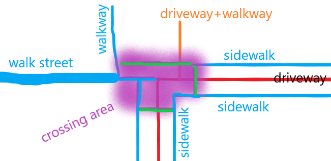
area:highway=pedestrianis already in use as the outline of ahighway=pedestrian, which is not what you have here.Britzz 于 2023年07月16日 13:45 的评论
There is a traffic_calming=table on your photography too, no ? Another solution : area:highway=footway & footway=crossing, i think it’s more precise
adreamy 于 2023年07月16日 15:56 的评论
@Britzz, Cool, I agree.
I took it as a roadway area but also a pedestrian area, but if you look at it as a footway area but also a crosswalk, the tag you suggested is a good choice.