
The streets & civic boundaries (though not Parish/Ecumenical boundaries) are well sorted for Nottingham & district; well done SK53 & will_p for a fantastic amount of effort to create that (at least in my neck of the woods). That prior work occasionally needs a small trim here or there, but mostly my survey work is to add house number/names. It is useful exercise & gets me out of the house, but can be very boring. Fortunately, Nottingham folk are house-proud, love their gardens & are naturally creative, and spotting the results all helps to keep me awake. Here are some more examples from Standhill Road, Gedling:—
As I understand it, it was british Victorians that began to name their terraces as “Villas”, and to often include the start-date. There are good examples of this in a little terrace of 5 houses; I especially love the ‘bird’s nest’ below the number for Hazel Villa:

…but it’s the owner of Vivian Villa that has really gone to town with the pot plants:

Interestingly, Gedling Council itself takes pride in being creative. This is the sign for the King George V Recreation Ground + some of the sequence of photos (Mapillary seems to be having difficulty in processing them):


According to this geolocation.ws page the recreation ground is within an extension of the Thorneywood Brickworks and, further, that there used to be a tunnel under Standhill Road linking the two clayworks.
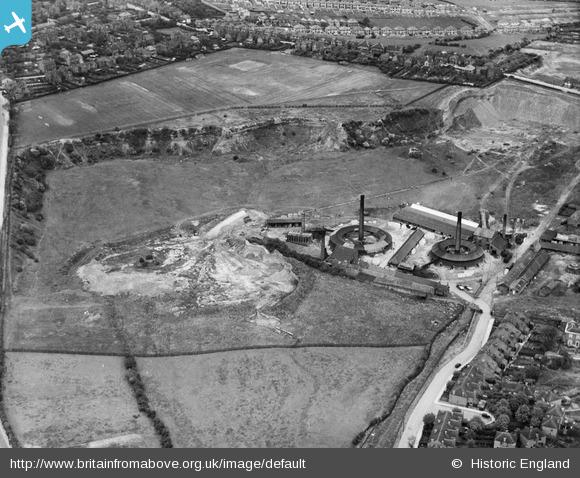
In the following 1938 picture (also in the 5 June diary) the recreation ground is at the top right-hand side, and Standhill Road can be seen running across the spur of land that remains between the two sets of clay workings:
Meanwhile, this Gedling Council Street-Guide PDF may be interesting to some, and especially due to the inclusion of a map. The map is copyright Ordinance Survey (of course), but I thought it a good contrast & compare to what OSM can do.
In a final coda, at the extreme top of Standhill Road is Porchester Junior School (the school urgently wants someone as a School Crossing Patrol person for Prospect Road if you live local) and, at the back of the school on Hillview Road, is number 61 on a plot of land that (a neighbour informed me) used to be “Sanders Farm”. So far, I can find zero information to confirm that assertion.
Discussion