OpenStreetMap logo OpenStreetMap

alexkemp's Diary

Recent diary entries

Harvey's Plantation

Posted by alexkemp on 13 April 2017 in English. Last updated on 4 July 2022.

It’s not often that I get the chance to enter something utterly new onto the Map, so please forgive me if I crow a little about this one. However, it will not be very loudly since, although I’m most certainly not an arboriculturist, IMO this copse of trees should be levelled to the ground, burnt to ashes & started again from scratch.

PS
IANAA makes a pleasant change to IANAL, does it not?

Harvey’s Plantation
A circular copse of trees; close to though unconnected with local buildings, it stands amidst farmland and, whilst a couple of hedges and a small stand of trees connect, it is alone. On the ground, local trackways appear to get close, though none connect directly & few are officially mapped. Gedling Council have stated in connection with a Preservation Order on the copse (below) that “…the woodland had been a local landmark for over 100 years and makes an important contribution to the landscape.”

This is a distant view from the North-East (the copse starts at the break in the tree-line at the left):–

See full entry

Location: Gedling, Carlton, Gedling, Nottinghamshire, East Midlands, England, NG4 4BH, United Kingdom

Public Footpaths & Drovers Roads

Posted by alexkemp on 12 April 2017 in English. Last updated on 4 July 2022.

My first discovery of a drovers’ road was last February (see also a terrific description by one of the History Girls). I think that I’ve just found another one in Gedling, plus an odd trackway nearby, plus a vast long Public Footpath, and a circular Plantation, all of which are most odd. However, one thing at a time, and for this diary entry it is to be the Public Footpath and a (possibly) unmarked Drovers Road.

The drovers’ road in Ware showed that, typically, Drovers Roads are marked as Public Byways on local signs. There is no such signpost for this one, which is why I keep using the words “if” & “possibly”. The field at the start of a very long Public Footpath [1+2+3+4+5] is most odd & when I saw it I went “THAT’S A DROVERS’ ROAD!!!”. See what you think:–

a drovers' road?

The original mapper was perplexed by what he saw & put in a fixme within the area (now removed):–

  • “not sure of the tagging here - basically it’s just full of thistles and not crops”

See full entry

Location: Rivendell, Stoke Bardolph, Netherfield, Gedling, Nottinghamshire, East Midlands, England, NG14 5HH, United Kingdom

Gedling Treasures

Posted by alexkemp on 4 April 2017 in English. Last updated on 4 July 2022.

Buildings in Gedling worth a second look:–
(see also Key:heritage + Key:listed_status + Key:HE_ref)

Gedling Borough Council claim 200 buildings to have been listed by Historic England within the area that they control, and offer a PDF to download with all such buildings listed by district (the PDF is based on information from a very old listing and not updated). There are just 7 listed for Gedling Village itself. Here are six that I mapped recently + an unlisted extra:–

Hardstaff Almshouses, Gedling

heritage=2
heritage:operator=he (“Historic England”)
listed_status=Grade II
HE_ref=1268312 (listing)
start_date=1935
name=The Mary Elizabeth Hardstaff Homes
wikipedia=en:Mary Hardstaff Homes
One of the ladies living here gave me the 3rd Degree interrogation, and with good reason. Many folks photograph these Almshouses on Arnold Lane due to their Grade II listing. The lady did not mind that, but she did mind folks that saw the photos then came round & nicked stuff from the gardens (there are many fine displays of gnomes & such-like in front of the homes). I was sorely tempted to picture some of them, but promised her that, on this occasion, I was photographing only the building:–

See full entry

Location: Gedling, Carlton, Gedling, Nottinghamshire, East Midlands, England, NG4 4BH, United Kingdom

Searching for the Source of Ouse Dyke #4

Posted by alexkemp on 1 April 2017 in English. Last updated on 6 July 2022.

[See Part #3 for Summary & Detail on the 2 streams that constitute the source of Ouse Dyke]

Part #3 brought the story of Ouse Dyke from it’s sources up to an old bridge across the lowest point of Lambley Lane. The bridge used to carry the Lane across the Dyke, and the stream still flows in a culvert below that bridge. That culvert follows the course of the original stream through modern housing north of All Hallows Church. I met residents living close-by that recall the original stream as lads & they confirmed each length & dog-leg on it’s way to Willow Park.

From the bridge the stream flowed at the bottom of the South Recreation Park; the culvert today (and the stream yesterday) travels under a walk between #122 & #124 that lets folks get to the Park from Lorimer Avenue.

Here is the bridge, the path of the culvert/stream through the Park & the walk to Lorimer Avenue:–

See full entry

Location: Gedling, Carlton, Gedling, Nottinghamshire, East Midlands, England, NG4 4BH, United Kingdom

Searching for the Source of Ouse Dyke #3

Posted by alexkemp on 31 March 2017 in English. Last updated on 12 January 2025.

[If any of the following does not make sense, then read Part #1 / Part #2 first]

Another survey yesterday (Thursday 30 March 2017) & I think that I can now say that the trace from source (or rather, both sources) & the beginning of the line of Ouse Dyke can be established. I needed to return to determine the line of the dyke from the Southern Basin to the beginning of it’s culvert, and then it’s passage between Lambley Lane & Jessops Lane. I’ve not only done both, but have met residents (and in particular a former Gedling Colliery miner) who have told me their memories from 40 years ago (1970s) as children or young men when the Ouse was placed in a culvert, and thus where it now travels, confirmed it’s course within Gedling Country Park and some have expressed concerns that the many streams that fed it may currently be undermining the culvert.

Below is a summary, and then horrible amounts of detail, of those findings:–

Summary

There are 2 streams that are the source for Ouse Dyke:–

  1. A stream to the west (name currently unknown) that originates within Mapperley Golf Course, empties into a culvert just north of Kneeton Close, and then travels south and east along the line of a stream which was part of the northern boundary of Gedling Village. After crossing at the dip in Arnold Lane the stream (now culvert) ran almost due east-west and met the 2nd stream in the middle of what is now Lambley Lane Recreation Ground.
  2. The eastern stream originates now as a Northern Retention Basin, which overflows into a Southern Retention Basin, which itself overflows into a dyke, which enters a culvert at it’s southern end and flows down to the original line of Ouse Dyke to a bridge across the lowest point of Lambley Lane, then south to Willow Park.

Detail

See full entry

Location: Gedling, Carlton, Gedling, Nottinghamshire, East Midlands, England, NG4 4BH, United Kingdom

A Personal Message from Fatty2000

Posted by alexkemp on 31 March 2017 in English.

Just received this PM:

Hi alexkemp,

Fatty200 has sent you a message through OpenStreetMap with the subject Good morning,: > Fatty200
> 31 March 2017 at 11:30

My name is Fatima, please lets talk very well with my email address[ fatimaabde23@gmail.com ] for good friendship and i will send you my pictures if you want. Thanks and take care.

(someone with the necessary admin clearances, please delete this idiot)
(he has gone - thank you)

Searching for the Source of Ouse Dyke #2

Posted by alexkemp on 29 March 2017 in English. Last updated on 4 July 2022.

(If any of the following does not make sense, then read Part #1 first)

It’s raining heavily this morning so no field survey (it kills the smartphone), but some most valuable desk-surveys using NLS - OS 1:25k 1st Series 1937-61 imagery within JOSM + a phone-call (+44 (0) 800 783 4444) to Severn Trent Water.

The culvert from Mapperley Golf Course was (badly) mapped using one of the NLS maps — probably NLS - Bartholomew Half Inch, 1897-1907, which is very low resolution and, in any case, few of them help much in accurate mapping. I’m going to trim the line of the culvert from Mapperley Golf a little to match the higher-res NLS maps; one of the reasons for this is that this brings the line of the culvert not only into line with the stream on those maps (one of the points where the earlier mapping went bad) but also with the point where that stream crosses Arnold Lane. At the moment the culvert passes straight through some houses on both The Fairway and High Hazles Close (not very likely) then across Arnold Lane north of the Village boundary. It is far more likely to have followed the original line of the stream, which would also have been Gedling Village boundary at that point. That would have taken it under the line of The Fairway (a private road) and across the bottom of the High Hazles Close’ gardens (that is almost due East-West, with the gardens to the north & a playing field to the south, a line of hedges in between. The old stream/OSM culvert then pops out close to the signpost on Arnold Lane that says Gedling Village, which also the lowest point of Arnold Lane on that section of road and thus where you would expect a stream to flow:–

See full entry

Location: Gedling, Carlton, Gedling, Nottinghamshire, East Midlands, England, NG4 4BH, United Kingdom

Searching for the Source of Ouse Dyke

Posted by alexkemp on 27 March 2017 in English. Last updated on 4 July 2022.

Oh yes! History is full of the names of famous Explorers, searching for the source…

…and so, in honour of these & other, similar noble exploits, on Sunday 26 March 2017 your mapper selflessly set forth into the wildlands of the heights of Gedling Country Park to discover the source of …, erm, Ouse Dyke (I do wish that they could have given it a bit of a more romantic name) and …, erm, got my Clarks muddy. So yes, no trouble nor expense shared to nobly & selflessly bring the wonders of Gedling slag heap to your door.

A short length of Ouse Dyke was marked up in those heights on the Nottingham City Adopted Highways Register, and I’d noticed obvious signs of a bridge across Lambley Lane that should contain Ouse Dyke (although now culverted), plus manhole covers for a culvert North-South across Lambley Lane Recreation Ground, so I was confident of a result.

Here are some highlights of that mapping session, using my new-new smartphone for the first time:–

A northern basin (mapping), fed by culverts & natural drainage from the surrounding hills. As best as I can tell, this is NOT a source for Ouse Dyke, although goodness knows what Severn Trent does if the rainfall is too large (correction: see later diary with photos of the overflow channel that allows the upper, northern basin to drain into the lower, southern basin and the way that the latter basin overflows into a culvert that is at the head of Ouse Dyke):–

See full entry

Location: Gedling, Carlton, Gedling, Nottinghamshire, East Midlands, England, NG4 4BH, United Kingdom

Views from Gedling Country

Posted by alexkemp on 26 March 2017 in English. Last updated on 4 July 2022.

My current mapping is on the eastern edge of Gedling. Gedling prides itself as a village, with an Anglican church that was established in 678 A.D. (the current church is a youngster at 1089 A.D.). Today, someone that lives in a bungalow at Field Close at the rear of the church was proudly pointing out to me the Peregrines that lodge in the niches of the spire. The tower is 90 feet high (27.4m) and the spire is yet another 90 feet, so that gives those dive-bombers an unrivalled perch for launching their attacks.

In spite of it’s history, Gedling is now more or less just another suburb of Nottingham. It does, however, skirt the countryside and I’m mapping on the edge of that country, so here are some views.

Want any Horse Sh.., er, Manure?

Glebe Farm is an abandoned stables just outside of the residential spread that has crept up Lambley Lane. It has suffered decades of blight due to development, the latest of which (Gedling Access Road, or “GAR”) looks like it may go ahead. There were some horses in the East fields, a Detectorist scanning the West fields, and below is Milo the dog, an energetic bull terrier that belongs to the lady that looks after the horses. Milo leapt up at me & introduced my buff-coloured trousers to the farm speciality (there are twin piles of the stuff in abundance near the gate if your garden needs any).

See full entry

Location: Gedling, Carlton, Gedling, Nottinghamshire, East Midlands, England, NG4 4BH, United Kingdom

Streams & Trees in Gedling, Notts

Posted by alexkemp on 19 March 2017 in English. Last updated on 6 July 2022.

Mapping in Gedling on Saturday 18 March in foul weather (it was raining hard; goodness me, could this be England by any chance?) (well, yes). My new smartphone turned out to NOT be as England-proof as my ISODRY-10000 jacket, but that’s another story.

There were one or two pleasant scenes & I thought to share them with you.

Right at the start of the track was an un-named recreation garden on Burton Road. It contained some yew trees (at the right) which sometimes is a sign of a former religious establishment in England. A neighbour said that there used to be a “big house, with stables” at the rear, but had no other information.

gardens, burton road gedling

See full entry

Location: Rivendell, Stoke Bardolph, Netherfield, Gedling, Nottinghamshire, East Midlands, England, NG14 5HH, United Kingdom

Spring Shows It’s Face Early in Nottingham

Posted by alexkemp on 15 March 2017 in English. Last updated on 6 July 2022.

We are fast approaching the Equinox (Lord Google tells me that it will be on Monday, 20 March at 10:28 UTC this year). Here is a splendid photo taken a week early of some St Ann’s municipal grass with Spring flowers, taken from St Ann’s Well Road looking North-Eastwards on Monday 13 March (and yes, England really is as green as that in Spring):–

English Spring in Nottingham

St Ann’s used to be known as Clay Field before it’s 1845 enclosure & development in the 1860s, 70s & 80s1. Under the road pictured above is a culvert carrying spring-water from the St Ann’s Well. That well was a medieval place of pilgrimage for Kings & others, but was destroyed in 1889 when the Nottingham Suburban Railway (NSR) was built. A photo from last year, showing the remains of the bridge pillar that killed the Well (together with some of the story of the NSR) is at the bottom of my 3rd Diary post.

See full entry

Location: Lace Market, St Ann's, Nottingham, East Midlands, England, NG1 1PR, United Kingdom

Lion of Nottingham Bendigo Finally met The Opponent He Could Not Defeat

Posted by alexkemp on 14 March 2017 in English. Last updated on 6 July 2022.

This is the Grade II listed statue & memorial placed above the grave for Bendigo In St Mary’s Rest Garden, Nottingham:–

Bendigo

“In life always brave, fighting like a lion…
In death like a lamb, tranquil in Zion”

Nottingham loves lions ([1] [2] [3] [4] [5]) and they so loved William ‘Bendigo’ Thompson that his funeral in 1880 had a procession a mile long with thousands in attendance. He was buried in St Mary’s Cemetery (now called the Rest Garden) and, a hundred years later, all gravestones except his were transferred to the back wall. Unfortunately his monument was carved in soft stone, and acid air from thousands of coal fires has not been kind to it across the last century.

This was said to be (the site has gone) the only photo of Bendigo (sourced from picturethepast.org.uk):–

See full entry

Location: Lace Market, St Ann's, Nottingham, East Midlands, England, NG1 1PR, United Kingdom

Radburn Design Housing in St Ann’s, Nottingham: 1860 + 1970

Posted by alexkemp on 9 March 2017 in English. Last updated on 7 July 2022.

Radburn Design Housing is houses arranged so that each house (often terraces of houses) present their backs to everyone else, whilst the fronts of each house face each other. It is named after a Radburn, New Jersey estate built in 1929 and has become a byword for bad practice (an Australian architect said of his own housing estate designed on Radburn principles:– “Everything that could go wrong in a society went wrong … It became the centre of drugs, it became the centre of violence and, eventually, the police refused to go into it”). It seems that Nottingham got there first in c1860, but also in 1970 with the St Ann’s redevelopments.

Nottingham was one of the last places in England to enclose Common Land (Laxton village still has “Open Fields”) and, until the 1845 Enclosure Act (not fully enacted until the 1880s), the fields to north & south of the old city were open fields & Common Land, meaning that the main part of the population was restricted within the town walls. At this time the population was soaring. The practical combination of those two factors was foul living conditions & mass death, largely from water-borne diseases such as cholera (see St. Mary’s Rest Garden) (a poignant tombstone from that former churchyard, commemorating the deaths of Henry Davis (died June 21, 1846 aged 8) and sister Elizabeth Davis (died December 9, 1851 aged 16) is below). It therefore seems reasonable to call the expansion of the town-folk out into 1,068 acres (432 ha) of the Clay Field (the former name for St Ann’s) an “explosion”.

See full entry

Location: Lace Market, St Ann's, Nottingham, East Midlands, England, NG1 1PR, United Kingdom

Using a SmartPrime7 Smartphone for Tracking

Posted by alexkemp on 7 March 2017 in English. Last updated on 7 July 2022.

It has been a year (or thereabouts) since I obtained a Vodaphone SmartFirst6 to replace my dearly-beloved Motorola L7 when it finally died after ~15 years due to the central bevel suddenly detaching. That caused me to come across OSM & OSMTracker & hence the last 12 months updating the map.

The Vodaphone SmartFirst6 was only £20 GBP together with a PAYG SIM. It was a good intro for an Android newbie who doesn’t play games, although a little slow & with a limited camera. Although the SIM was locked to Vodaphone, the phone allowed a £25 GBP 64GB microSD card to be fitted (which could be mounted via USB connection to Linux/Windows) plus allowed .apk files to be transferred to the SD-Card & then installed into the phone. So, it would have been £100 GBP a couple of years ago and really, at £20, who can complain?

F-Droid supplied OSMTracker 0.6.11 FoC (2015-08-21 & still the latest ready-compiled version) (see the wiki for compile instructions on the latest update). I make use of the GPS breadcrumbs (basic tracker feature), voice-notes & photos, and that is it.

The SmartFirst6 runs Android 4.4.2 (custom Kit-Kat) and I was worried about the lack of security updates in addition to a lousy camera. The SmartPrime7 runs Android 6.0.1 (Marshmallow) and should be good for now (it was released last December 2016) (£65 GBP + £10 GBP for PAYG credit). Here are a couple of issues I’ve managed to overcome:–

See full entry

Location: Lace Market, St Ann's, Nottingham, East Midlands, England, NG1 1PR, United Kingdom

The Most Confused Roads in Nottingham

Posted by alexkemp on 27 February 2017 in English. Last updated on 7 July 2022.

At the end of my most recent mapping session in Gedling, Nottingham I mapped Albert Street & Victoria Street. It was only right at the very end that I got the point (Victoria & Albert: geddit?). It is immediately obvious from the state of it’s road that Victoria Street is unadopted (a private road), but I was surprised to discover that the end of Albert Street is also unadopted. My goodness, but it is confusing…

This photo shows not just the state of Victoria Street (it is the road in the foreground) but also the locked-gate that lorry drivers keep trying to use to cut through from Westdale Lane East (at the end of the service road) to Main Road (well behind the camera) (I’ve done my damnedest to make sure that that does not happen with OSM):–

Albert Street gate

See full entry

Location: Gedling, Carlton, Gedling, Nottinghamshire, East Midlands, England, NG4 4BH, United Kingdom

Desolation Alley

Posted by alexkemp on 26 February 2017 in English. Last updated on 7 July 2022.

I appear to be obsessed with broken-down garages. Here is one of the best examples so far, next to Priory Road,Gedling (otherwise, a very smart road):-

desolated garage

Update 7 July 2022

Mapillary has changed it’s download URLs & therefore all links within my diaries that used a Mapillary download URL in the old format are broken (the Mapilliary map URLs, which show a photo within the context of an OSM map, have also changed and are redirected via a HTTP/1.1 302 Found, but the download URL hostname no longer exists and gives a “No address associated with hostname” DNS error). I’m slowly going through to update them. The new URLs are terrifyingly long, but show OK on my screen (and I hope also on yours).

Location: Gedling, Carlton, Gedling, Nottinghamshire, East Midlands, England, NG4 4BH, United Kingdom

Chasing All Hallows through Gedling

Posted by alexkemp on 18 February 2017 in English. Last updated on 7 July 2022.

As best as I can work out, the first photo that I took of All Hallows Church, Gedling was on September 19, 2016 from near the top of Chatsworth Avenue looking north north east:–

all hallows church, gedling

September 21 2016 saw me receive the chilling news about The Chancel Tax.

Throughout the rest of September & October I kept my head down & mapped to the West then North. By 23 November it was Arnold Lane outside Scot Grave Farm heading south-east and suddenly we caught a distant view of the church again:-

See full entry

Location: Gedling, Carlton, Gedling, Nottinghamshire, East Midlands, England, NG4 4BH, United Kingdom

The Remains of Phoenix Farm, Gedling

Posted by alexkemp on 15 February 2017 in English. Last updated on 7 July 2022.

Last December I wrote about Phoenix Farm, Gedling, a farm with a direct connection to JRR Tolkien & his most famous book Lord of the Rings. There are a dozen pubs, churches, streets, etc. in Gedling named after this farm + an electoral ward; naturally, the farm itself was knocked down in 1954, and the residential estate named after it was built on it’s ashes.

As best as I can tell, this set of garages were built on the site of the farm buildings:-

Phoenix Farm, wings clipped

See full entry

Location: Gedling, Carlton, Gedling, Nottinghamshire, East Midlands, England, NG4 4BH, United Kingdom

Highways & Byways: Roman & Drovers’ Roads in Ware, Hertfordshire

Posted by alexkemp on 7 February 2017 in English. Last updated on 8 July 2022.

Most of the places that I’ve mapped across the last 10 months have been ~1930s with the occasional Victorian terraces (1880s). The topic today arose from looking at the deeds of a 1906 house but, as the first words of the first line below makes clear, has far more ancient origins:–

  • In 13th Century England the following two, apparently contradictory, statements are both true:–
  1. Most people were born, lived & died within the same 5 mile (8km) radius.
  2. England was covered with a network of streets & roads each many hundreds of miles long; further, these streets & roads were continually thronged with people travelling long distances upon them.

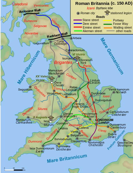
“Streets” here refers mostly to the well-known Roman Roads. During research for this Diary entry I was surprised to discover that Ware was positioned upon Ermine Street, a Roman Road that stretches from London to York & crosses the Humber close to my birth town of Hull. For reference, here is a map of Roman Roads:–

Roman roads in England

See full entry

Location: Ware, East Hertfordshire, Hertfordshire, England, United Kingdom

Fix for ‘Java-8 Will not Upgrade since Jan 2017’ under Debian Jessie

Posted by alexkemp on 6 February 2017 in English. Last updated on 7 February 2019.

tl;dr: use the following from a console:

$ sudo apt install -t jessie-backports openjdk-8-jre-headless ca-certificates-java

JOSM needs Java-8. Open-Java-8 is available via Jessie Backports, but the current update (8u121-b13-1~bpo8+1) needs updated CA-Certificates which were not previously available from Backports (see Debian bug#851667). Unfortunately, Synaptic will not spot the updated certificates in Backports since it keeps holding back openjdk-8-jre, etc.. Thus, the need to use the console line as at top.

Unfortunately, I’d worked my way through the very-useful AskUbuntu question on:

“E: Unable to correct problems, you have held broken packages”

…and had therefore removed all Oracle + OpenJDK Java8 (which meant that all JOSM was also gone & all my Java alternatives reverted to Java7). However, it also meant that I had a different error message on attempted reinstall of Java-8:

$ sudo apt-get install openjdk-8-jre openjdk-8-jre-headless ca-certificates-java
  ...
  The following packages have unmet dependencies:
   openjdk-8-jre-headless : Breaks: ca-certificates-java (< 20160321~) but 20140324 is to be installed
  E: Unable to correct problems, you have held broken packages.

That allowed me to find a Unix Stack Exchange Q which solved the issue. Now I need to reinstall JOSM & make Java-8 the system default (sigh)…