
SME.sk displays presidential election results on OpenStreetMap
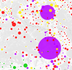
ایہہ 17؍March 2014ء English وچ «andrewsh» لیکھ چھپیا گیا سی۔Slovak news website SME.sk has published an interactive map prepared by Michal Škop which visualises the results of the first round of presidential elections that took place here last Saturday. Quite surprisingly, this map uses OpenStreetMap as the base layer, and Leaflet as its web map library to display nice coloured circles over the map with detailed statistics popping up on mouse click.
Discussion
ایہہ 17؍March 2014ء 14:48 تے «Stalfur» ٹپݨی کیتی گئی سی۔
Don’t think it is surprising as it is free to use. The stranger thing for me is that the colored bubbles are in the color of a narrow winner, does that mean they get all the votes from that district (first past the post) or is it just the combined votes all over country that make sure who gets to the second round?
The huge Bratislava circle for example show very narrow margin for the winner.
ایہہ 17؍March 2014ء 14:54 تے «andrewsh» ٹپݨی کیتی گئی سی۔
The label over the map translates as ‘The size of a bubble shows the number of voters [in the town], and the colour corresponds to the winner’. A little bit strange, yes.
ایہہ 17؍March 2014ء 14:56 تے «andrewsh» ٹپݨی کیتی گئی سی۔
Try choosing different candidates from the combo box near the next map (not OSM, presumably, but the official cadastre rather, I think). It distorts the map in fish eye style and display nice animation of a histogram being sorted :)