
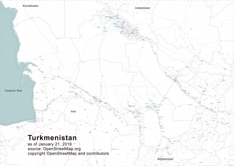
Many thanks to the fellow mappers who urged me to delve into Osmosis and use it to extract excerpts from the OSM database so that I could then use Maperitive to generate a wall map of Turkmenistan’s highways. Osmosis is a challenge–the documentation is obtuse, frankly–but I managed to pull some extracts from the OSM database, feed them into Inkscape (another rather challenging piece of software), produce an SVG file that could then be lightly edited to remove unneeded items, and then pump out first a PNG file and then convert it to a JPEG using Corel Photo Paint. The result is a roughly 60” by 81” or so wall map of Turkmenistan’s highway network, from highway=primary to highway=tertiary, plus railroads, cities/towns/villages, and gas stations. I can now send it to a print shop. This was not a trivial task but the result will be quite useful to the motor pool chauffeurs at the U.S. Embassy in Ashgabat, and perhaps to others as well.
討論
由 alexkemp 於 2019年01月23日 19時25分 發表的評論
The image (“Map of Turkmenistan highway network”) is broken. That is because the URL is for a web-page (osm.wiki/File:190123_TKM-smaller.jpg), but you have it enclosed in an image tag. You should use one of the image urls; the biggest (very slow) is osm.wiki/w/images/5/57/190123_TKM-smaller.jpg, though the smallest should be fine for a Diary post (osm.wiki/w/images/thumb/5/57/190123_TKM-smaller.jpg/800px-190123_TKM-smaller.jpg).
由 alexkemp 於 2019年01月23日 19時45分 發表的評論
I would have suggested a different route if you are using Inkscape to produce a printed-map.
Instead of:
…use:
The main advantage becomes that you would retain all vectors & text as mathematical curves, which means a highly-professional end-product (most essential for very small text + map-features). PDFs are found via the
File | Save-Asoption (choose ‘PDF’ from the drop-down at bottom-right).Note:
The SVG file is designed as Inkscape’s native file-format. In certain circumstances it will make use of v1.2 methods which are now deprecated (web-SVGs can only use v1.1 features until v2 gets accepted). If you try to use the native SVG on a web-page it will show odd artifacts if it contains any v1.2 features.
由 Warin61 於 2019年01月23日 21時26分 發表的評論
Software documentation is written in a language all of its own.
由 apm-wa 於 2019年01月24日 01時15分 發表的評論
@alexkemp, thanks very much for the tips! I’ll give the SVG-> PDF option a try. My intended end product is a wall map roughly a meter high.
@Warin61, yes, no joke!