OpenStreetMap logo OpenStreetMap

b-unicycling's Diary

Recent diary entries

Tracking down National Monuments in Ireland

Posted by b-unicycling on 27 January 2023 in English. Last updated on 16 February 2023.

As usual, I can’t quite remember how it started, but this week, I was trying to find a list of all the National Monuments of Ireland. The National Monuments Service publishes lists by county which only contain the ones under state care. These lists have made their way to Wikipedia which is a great start. They have their numbers recorded there which I have transferred to OSM under ref:IE:nm for the counties of Kilkenny, Laois and Offaly so far. (the key is recorded on the wiki, of course.)

I have sent an email to the National Monuments Service asking for a list, but so far, no reply. I probably have a reputation there by now…

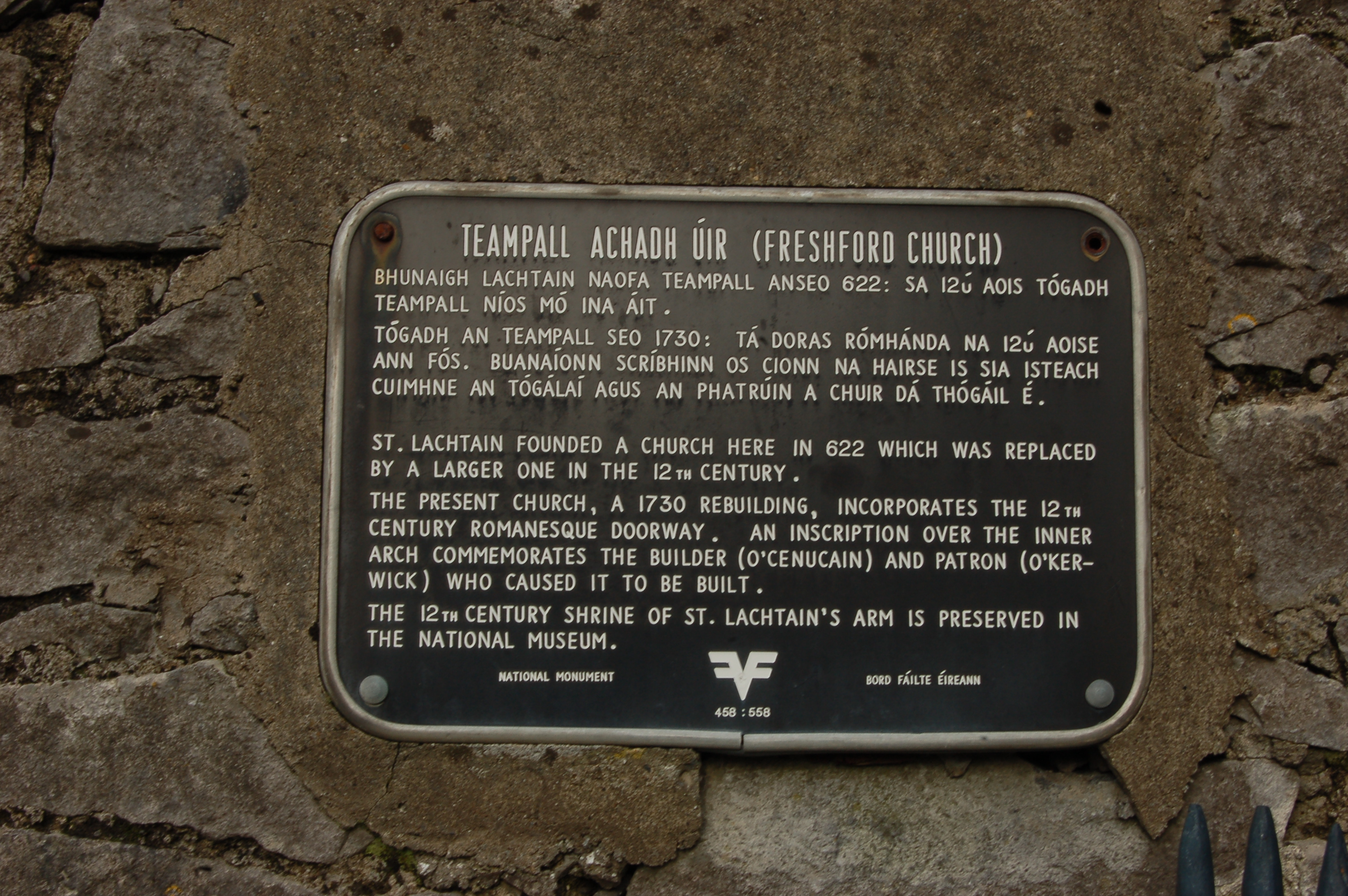
However, I noticed while visiting and taking some pictures of Freshford Church that it has a black plaque (the type of which I had seen before, but never read in much detail) which stated that it was a National Monument.

plaque

See full entry

Tumuli and barrows

Posted by b-unicycling on 18 January 2023 in English.

I’ve been looking at tumuli the last couple of days. In Ireland, they’re usually called barrows, but according to Wikipedia, it’s the same. So I went and tidied tagging in some of the features tagged as barrows (mostly site_type=ring-barrow/round_barrow and archaeological_site=ring-barrow/round_barrow etc).

I’ve also added that very important information to the wiki and created a table of the most commonly used tags related to tumuli/ barrows.

I noticed some possible duplicates in the tagging: I would think that round_barrow and round_tomb are the same, for example. Some of the tumuli tagged as mound probably fall into that category as well.

This morning, I started drawing some of the types and uploading them to WikiCommons (all as CC0), mostly after photographs I found online, because there didn’t seem to be any diagrams of the different types on WikiCommons. Most of them are just rough schematics (I say rough, it took me forever to draw every single stone), but one is actually a specific keyhole tomb in Algeria (there are hundreds mapped in Algeria!):

See full entry

fieldpapers non-functional

Posted by b-unicycling on 11 January 2023 in English.

I was going to do some more field name surveying next week, but shock, horror, it is no longer possible to “make an atlas” on fieldpapers.org.

error message fieldpapers

DeBigC and I have tried to find out why. There was a post on GitHub, even before I noticed it, but no reply. DeBigC was more successful on Reddit, where the reason is given as having run out of funding.

This really is a shame; it was such a useful tool. Maybe there is a way to bring it back?

EDIT 11-01-2023 21:41: It’s back working again, very strange.

New personal milestone and many more stones

Posted by b-unicycling on 6 January 2023 in English. Last updated on 7 January 2023.

Earlier today, I reached my 5 millionth edit. It came to my attention about 10 days ago that I was approaching it, because someone on Twitter had celebrated their 15,000th edit, and I went to check mine on neis-one. I then estimated that it would take me 10-14 days to reach it, and I was right.

My friend DeBigC had given me some praise already in his diary some days ago.

Next stop, 10,000,000, I think. Well, not really stop, just a goal.

It’s not that difficult to get that many changes when you’re working on a big project like Irelands #osmIRL_buildings project. We started on Co. Roscommon mid December 2022, and apart from buildings, I’ve already added 1150km of drystone walls. You read that right. dry stone wall statistics from ohsome.org Part of that was discovering several field systems of unknown date, but I have documented the use how I tag them on the wiki. I don’t expect many field systems like that to survive in many other countries, it’s just that history is all over the place in Ireland.

See full entry

Location: Onagh, Taghmaconnell Electoral Division, Athlone Municipal District, County Roscommon, Connacht, Ireland

more micromapping for historic sites

Posted by b-unicycling on 21 December 2022 in English.

What do people think about adding archaeologist_name and archaeologist:wikidata to archaeological sites that have been excavated? It is very niche, I know, but it would help find literature about the excavation, once you have the name of the site director and the location, it should be possible to find literature associated.

It would be very similar to what we do with artwork and associating the artist with it.

I’ve started doing it, but only for two sites so far (1 and 2), because I happened to know who excavated there and because they have wikidata entries.

It would be a great job for all the Time Team fans out there! #justsaying

And I’m not trying to make OSM into a history map, in my defence; I still map a lot of contemporary things.

Location: Coolure ED, The Municipal District of Mullingar — Kinnegad, County Westmeath, Leinster, Ireland

AED Survey

Posted by b-unicycling on 1 December 2022 in English.

Motivated by OpenStreetMap Poland’s openaedmap.org, I went on a targeted survey of AEDs in Kilkenny. I had added some before, and I always do, when I see one, but this time I put some extra effort in, knocked on doors etc.

According to overpass, I’ve edited 141 AEDs, but some are in areas I’ve never been to, so I don’t know how that happened. Unless I used mapillary…Impossible to remember.

Kilkenny is a small Irish town with a lot of tourism. (They want it to be called a “city”, because they got that status in 1609, but the numbers are telling a different story.) I started off using openaedmap.org on my phone, but then I learned about the Quick Actions on OSMAnd, made myself one for AEDs and used it from then on.

Over the course of two days (3-5 hours in total maybe), I went into most

  • hotels (50-50 chance)
  • supermarkets (SuperValu and Dunnes good coverage, Lidl not)
  • shopping centres (100% with 3 surveyed)
  • banks (bad coverage with 2 surveyed, AIB and Permanent TSB)
  • some doctors’ offices,
  • churches,
  • public offices (good coverage)
  • major tourist attractions (coverage depends on size and operator)
  • social facilities (good coverage)

in an about 1km radius etc. Not only was I able to add about 23 unmapped AEDs, but I also raised awareness about the bad coverage after 6pm, because many businesses close then, and none of the AEDs surveyed during these days are outdoors and publicly accessible. Some people also weren’t aware about the closest AED to them or had outdated information.

When I got into longer chats with people, I also got a chance to mention openaedmap.org, and stickers or cards would have come in handy, but they might find it anyway.

See full entry

Location: Gardens, Kilkenny, The Municipal District of Kilkenny City, County Kilkenny, Leinster, Ireland

After having had my finds reported on in their online newspaper last week, the Kilkenny People today had a half-page article reporting about my discovery of three crannógs in Co. Cavan. newspaper article

This time, the journalist did a bit of extra research. Last time, when I discovered the two enclosures (as mentioned in this article), they used my press release almost verbatim. It must be newsworthy, if they put extra effort in. I wouldn’t know, I’m biased. :P

I sent them the press release about two weeks ago mentioning OSM as often as possible, because there is still a lot of ignorance in the general public about it. So, I will definitely keep on reaching out to the press every time I discover something, just to hammer the message in about OpenStreetMap.

See full entry

Location: Parisee, Castlesaunderson ED, Cavan-Belturbet Municipal District, County Cavan, Ulster, Ireland

video series about crannógs

Posted by b-unicycling on 21 November 2022 in English. Last updated on 3 December 2022.

I’m still “obsessing” about crannógs. There are now 205 mapped in Ireland and the UK with site_type=crannog. The timing is unfortunate with the proposal about changing site_type=crannog to archaeological_site pending, but I have been delayed for so long; I did not want to wait any longer. I’m adding disclaimers to every video to keep watching out for tag changes…

Five parts of a mini series about crannógs are planned, two of them have been published on my channel already, one will go public next Saturday.

I have created a page on the wiki mentioning some of the sources for finding crannógs, and I’m basically covering all the options in these videos.

I’m hoping to gather some interest from historians and archaeologists in OpenStreetMap with this. Long shot…

More archaeological discoveries

Posted by b-unicycling on 29 October 2022 in English.

As some will know by now, crannogs are my “thing” at the moment. I was hoping to produce a couple of videos about them on my channel, but it takes a bit longer to get the tag approved than expected. And I can’t tell people how to map crannogs when there is no standard.

But I digress…

While mapping buildings in Co. Cavan in Ireland, I had discovered 12 suspiciously circular features in the lakes within the last 3 weeks, and I had reported them to the National Monuments Service this week. They got back to me yesterday and confirmed 3 as actual crannogs (the rest were apparently just naturally occurring circular vegetation).

If you want to check them out, Bing or Esri Clarity imagery are best.

There are a couple more to report, but I’d rather do it in bulk than send an email every 3 days or so.

I made a quick video about it: https://youtu.be/7BJukQ8hKXw

history is a hot mess

Posted by b-unicycling on 17 October 2022 in English.

Still influenced by my proposal for settlement_type=crannog, I’ve looked at how historic settlements are mapped on OSM. There are three more or less “right” ways to do it (and so many wrong ones…). The three options are * map as historic= [whatever type of settlement] * map as historic=archaeological_site + site_type= [whatever type of settlement] * map as historic=archaeological_site + site_type=settlement + settlement_type= [whatever type of settlement]

The distribution today1 was (in reversed order from above, sorry):

settlement type/ form settlement_type=* site_type=* historic=*
ringfort 131 2 0
crannog 82 0 2
hut_circle 24 348 1
oppidum 8 15 3
city 6 612 16+(messy mapping) 2
village 3 11 58+ (messy mapping3)
town 2 0 12 (+ 3 “ghost_town”)
longphort 1 0 0
rundling 1 0 0
hut_site 1 0 0
hut 0 0 12
vicus 0 24 0
shieling 0 0 20 371
settlement n/a 3 788 ~25

In my opinion, historic= [whatever type of settlement] should only be used when the remains are still recognizable as buildings, like a ghost town or some sort of preserved settlement used as a museum (or “visitor experience”, as they’re now known), like some of the Pioneer towns in America.

Everything else I would classify as an historic=archaeological_site, and I personally would like to be able to classify settlements as such and then use sub-classification, if they are known. The high number of site_type=settlement supports that in my opinion.5

See full entry

tidying of site_type values

Posted by b-unicycling on 15 October 2022 in English. Last updated on 17 October 2022.

Following the discussion over my proposal for settlement_type=crannog, I have done some clean-ups in the Historical group. Dear me, it was needed.

Today, I tackled site_type on taginfo which comprised of 38 messy pages. I spent 3.5hours

  • fixing spelling mistakes
  • changing upper case to lower case
  • changing spaces to underscores
  • translating values from a myriad of languages into English etc
  • translating and fixing values for historic:civilization
  • moving values from site_type to description or name
  • etc.

faulty tagging for hill forts

See full entry

Mapping inspired by True Crime

Posted by b-unicycling on 4 October 2022 in English.

Has anyone ever mapped an area because it was in some true crime podcast or video? I mapped the area (i.e. buildings) in Co. Cork in Ireland where the Sophie du Plantier murder took place while listening to a podcast about it.

And then Netflix went and made a documentary about it and used all that lovely OSM material without attribution.

Location: Dunmanus West, Dunmanus, West Cork, County Cork, Munster, Ireland

tidying stiles

Posted by b-unicycling on 26 August 2022 in English.

I was preparing a video tutorial about stiles (online tomorrow morning on my channel). Even though I have mapped quite a few stiles while hiking, I came to the realization that I had mapped a lot of them wrong (mostly using OSMAnd, where I have to remember a lot of tags, bc they’re not presets) after reading the wiki page barrier=stile. Oops. While reading the page, it occurred to me that it was a bit messy, so I tried to tidy it up a bit and tried to find some examples for such cases that are a bit tricky to decide, like the stepover. I had tagged some of those as ladder, because they included more than one step.

I also took a look at the taginfo for the stile values, and boy, was there chaos! I mean, we’re mostly all humans, so we make mistakes and typos which might then be propagated through auto-text in JOSM or copying and pasting, who knows. I actually found one mistake I made myself this way. Some were obvious typos (steover) that I could correct without having visited the site, for others, I contacted the person who had added them (sometimes as far back as 8 years ago, so they couldn’t remember, and just had to delete the stile=* line, unfortunately).

But I also looked at commonly used ones like hipster and added explanations to the wiki page. Two I had to translate into English, and I hope I did it correctly, because they were both in languages I don’t speak, so I used image search to figure out what could be meant. I reduced the list from 4 pages of values to 2.5, so it’s a bit tidier now.

See full entry

Update on thatched building mapping

Posted by b-unicycling on 3 August 2022 in English. Last updated on 5 August 2022.

Disclaimer: yes, I know, it’s absolutely micro mapping, but see “Side effects”.

It’s now been about 4 weeks since I started mapping thatched buildings in Ireland more systematically than just ad hoc adding roof:material=thatch whenever I saw one. I had focussed on Co. Kilkenny, because of a 1994 survey carried out by thatcher and archaeologist Jimmy Lenehan in that county, so all I had to do was revisit the sites and check whether the roof:material was still the same. I ended up visiting about 58 of of the 106 sites in his survey. (I tried to remember to add survey_date to those, so I could run an overpass query.)

He also told me about some newly thatched buildings, where I could add the tag, too.

I also had a long talk with him in his own thatched house which was a very interesting experience, because it was a very warm day (for Ireland), and the thatch really did insulate the house really well. He is not very good with technology, but I think he understood the potential of mapping the thatched buildings on an OpenData platform. I’ve added ref:IE:lenehan to the buildings from his survey and documented the tag in the wiki.

I also had a chat with our Heritage Officer who thought it was a good idea to undertake a new survey, but doesn’t seem to grasp the advantages of crowd sourcing and OpenData quite as much as I would hope. She is under the impression that I’m only doing a photographic survey, because I told her that I was uploading the photographs to WikiCommons (about 82 uploads for Co. Kilkenny so far). She asked if I would provide these images to their county archive as well, because “not everybody knows how to use that OpenData thing”. Well, everybody knows how to use Google, that should bring them to WikiCommons straight away. So I politely explained that and declined providing duplicate content. Needless to say, there is also no public funding for a survey this year, so I’ll just soldier on in my own time and out of my own pocket.

See full entry

Location: Clasharoe, Portnascully, The Municipal District of Piltown, County Kilkenny, Leinster, Ireland

mapping thatched buildings

Posted by b-unicycling on 6 July 2022 in English. Last updated on 12 July 2022.

I’m preparing a video tutorial on thatched buildings - it’s dead simple, but it’s an interesting topic, I thought. So I was doing a bit of research trying to learn something about local thatching traditions and came across a 1994 survey by - it turns out - a thatcher. I only came across one volume which is basically a photo album of 106 thatched buildings in Co. Kilkenny with handwritten captions given the location. Location being in most cases the townland. But because it is handwritten and because this is Ireland, I have not been able to identify all the townlands.

What I’m doing now is trying to find the townland and trying to identify the building. Most times, if there are other buildings in the picture, it is possible to spot them in the townland by comparing the arrangement of buildings. Luckily, most buildings in Co. Kilkenny are mapped thanks to our #osmIRL_buildings project. And luckily, those are mostly old buildings, so I don’t have to worry about them being built since 2019. The National Index of Architectural Heritage is somewhat helpful in that they have indexed some of those buildings, but not all. They have a map where you can find a blue dot for those marking the spot. However, they are not always correct. They also have pictures of those buildings (sometimes also the wrong ones) which I can compare to that survey/ photo album. Sometimes, rarely, because those are very rural areas, I have mapillary to work with.

If they are not too far away and accessible for a non-driver like me, I’ll go and check them out in situ, take mapillary and a photo or two for Wikimedia. #OpenData, baby!

You can kind of see on Esri World Imagery (Clarity) Beta, whether it is thatched or a slate roof, because the thatched roofs have smoother corners and the colour is a bit different.

See full entry

Location: Knocktopher Manor, Knocktopher, The Municipal District of Callan — Thomastown, County Kilkenny, Leinster, Ireland

Busman's holidays in North Wales

Posted by b-unicycling on 18 June 2022 in English. Last updated on 20 June 2022.

First of all: North Wales is lovely, and I’d definitely go there again.

I went for a short holiday to North Wales with DeBigC this week and did a lot of mapping while there, but that was intended. Let me break down what we did:

Mapillary

Very little mapillary had been done, so we walked around (I’m especially pleased with the walk on the Conwy town wall) and also captured as much as we could on the buses we took (see below). Capturing mapillary on the bus has the advantage of getting a slightly different perspective than on the car. The disadvantage is that we didn’t bring phone holders to attach to the window, so our arms got a bit tired after a while. Show mapillary captured by me

Bus travel

See full entry

Location: Bangor, Gwynedd, Wales, United Kingdom

Now that the weather is more welcoming, i.e. dry, I’ve gone back to mapping walking and hiking trails in my area. I had done that before, either added the trail completely new as a relation with all that’s included, sometimes just added the trail markers, where the trail was already mapped. Most times, I try to do mapillary as well, sometimes just with the phone, sometimes with a 360° camera.

Today, I went to map the O’Gorman’s Lane Loop which is only a 4km walk (that is if you don’t get lost…), but it meets another, longer trail which was already mapped. But anyway, I ran into an American couple, Don and Kim who are exploring Ireland on rented motorbikes, but are also avid hikers and have hiked across the Czech Republic, Germany, Switzerland etc. Don was telling me that he has this app maps.me which shows all the trails and it’s free! And I said, well, it’s people like me who add those trails to OpenStreetMap which in turn adds it to your app. We parted ways, but I had a suspicion that I would run into them again after in the only café in the village. And I did. I walked up to them and gave him an openstreetmap.ie sticker (always handy in any bag I carry around). Once I had taken off my backpack, he could see the “OpenStreetMap surveyor” on my high viz vest, and the penny dropped. He had loads of questions and all the right ones, so I joined their table and chatted away with him.

He said that he wanted to map all the benches along the Camino. :D (We had noticed earlier that there are never enough benches along hiking trails in Ireland.) He also wants his name on one of those benches, and I explained that those little plaques can be added to OSM as well. He was very impressed, I think. They wanted to pay for my scone, but I had already paid. But we decided to share a taxi back, even though I would have been fine on the bus, and had told them about the bus as well.

See full entry

Archaeological Discovery

Posted by b-unicycling on 28 April 2022 in English. Last updated on 8 May 2022.

I have very exciting news to share, but a disclaimer first: I am not an archaeologist; I have only picked up a bit of knowledge here and there through my interest in the topic. taskmanager County Tipperary As I am working my way through the task of mapping all the buildings in County Tipperary in Ireland, my process usually involves switching from the Esri World Imagery (Clarity) Beta satellite imagery to the British War office map layer to see whether there are any historical things I can add as well. This is not part of the task (apart from the odd housename or name of a ruined church or castle), but it’s what keeps this tedious job interesting for me. A common feature I can add are ringforts (Wikipedia link), an early medieval settlement form in Ireland, often enough easily identifyable on the satellite imagery as a circular group of trees or a crop mark.

See full entry

Location: Garryard, Nodstown, The Municipal District of Cahir — Cashel, County Tipperary, Munster, Ireland

The Pursuit of Dermot & Grania (or Diarmuid and Grainne)

Posted by b-unicycling on 11 April 2022 in English. Last updated on 17 April 2022.

To help me procrastinate from mapping the buildings in Co. Tipperary and because I came across one of them recently, I’ve decided to go on my own pursuit of Diarmuid agus Gráinne on OpenStreetMap. There are a couple of instances on the British War Office map all over the country that are marked as “Dermot & Grania’s Bed”. According to Irish mythology (to cut a very long story short), Grainne made Diarmuid flee with her from her engagement party, and they fled across the whole country, sleeping out in the open (first separate, later not so much).

Throughout history, secretive or mysterious places like caves, dolmens etc have been given that name. The legend is mentioned a couple of times in the Schools Collection on duchas.ie, so that is what I’m using now to track them down, because I cannot search the British War Office map. Unfortunately, I can only read the English texts… But their journey will be trackable, once I am done.

Maybe I’ll get to see one of them at some point.

I’m using the hashtag #Diarmuid&Grainne for my changesets, if anyone wants to check it out. Check for yourself on overpass-turbo. (Thanks, Daniel!)

See full entry

Location: Disert, Binbane ED, Donegal Municipal District, County Donegal, Ulster, Ireland

I went house number surveying with StreetComplete yesterday in Callan, Co. Kilkenny. They have some very strange house numbering there, I can tell you.

One case, where whoever screwed the numbers on the door got them mixed up, so the sequence goes 34, 35, 63, 37 etc. But that’s what’s on the door, so that’s how I mapped it.

Another case, where the sequence is out of order, but presumably, because the houses got their number in the order they were built in.

Then I continued along Mill Street into what would eventually become Collins Park with a sign of the name in English and Irish in a wall (mapillary), so at least, I had some idea of the street name. However, the numbering continued from Mill Street (with ridiculously high numbers for Ireland, if I may add). I decided to ask the resident of no. 462 what street he lived on, and his answer was “The sat nav says Collins Park.” Very likely (everybody I know who isn’t a mapper uses it), that means GoogleMaps. So, what street do I put under addr:street? Do I follow the logic of the sequencing and give his house addr:street=Mill Street, yet adding “Collins Park” as the name to highway=street or do I follow the local’s information which in this case is very, very likely taken from Google? And which could easily lead to duplicate numbers for the same street?

I’ve done it the other way around for now, but I’m not happy with it.

A similar problem occurred elsewhere, where the name of the street “Green Lane” presumably continues from where I saw the only sign (sorry, no photograph, but it’s the street that led/ leads to the Fair Green), but the sequence on one side of the road continues from Mill Street, but across the road, one of the houses had “2 Kingscourt” (mark the different spelling from the actual street name - Kings Court - , FFS, isn’t anything easy in Callan?!). After my tagging, the houses on either side belong to different streets which they are not physically on.

See full entry

Location: Bolton, Callan Rural, The Municipal District of Callan — Thomastown, County Kilkenny, Leinster, Ireland