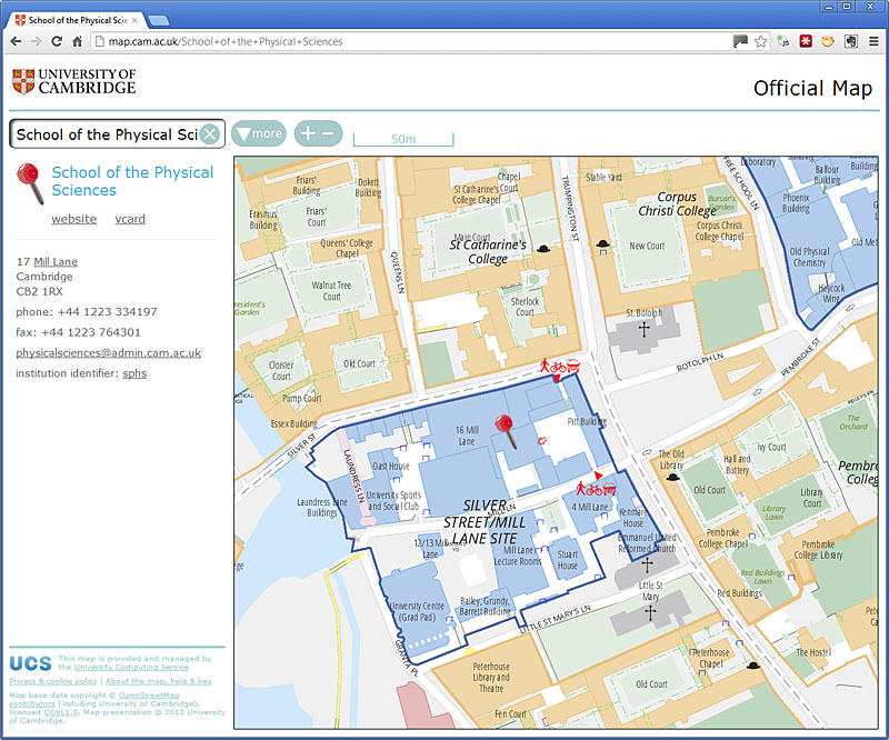
University of Cambridge map now live
Postat per davidearl a 2 d’octòbre 2012 en English Darriera actualizacion de 3 d’octòbre 2012I am pleased to say that the University of Cambridge’s new online map is now live, at http://map.cam.ac.uk , and linked off the University’s home page at http://www.cam.ac.uk .
This is the outcome of Project Drake, started a year ago. Surveys were conducted, with the data going into OSM. The data is rendered to a custom style loosely based on a previous non-OSM one. There is a database of the OSM data to support street name and third-party location searches and a database of institutional contact details. The two are loosely linked using the ref tag so that the university database can determine where an institution is located geographically. There is an API; and a separate presentation on small screen devices.
A paper map is also in final draft form.
There is some background the project here: osm.org/user/davidearl/diary/15398 and here: osm.org/user/davidearl/diary/17050
The University’s Computing Service has published a news release, here: http://ucsnews.csx.cam.ac.uk/articles/2012/09/24/new-university-map-launched
The University is intending to redesign its web pages from the end of the year, so the styling will change again before long.
Discussion
Comentari de Richard lo 2 d’octòbre 2012 a 16:59
Superb.
A query from an interested journalist - what maps were the University using before? Let me know and I’ll feed back.
Comentari de davidearl lo 2 d’octòbre 2012 a 17:11
@Richard, thank you!
The old maps used sections from an Adobe Illustrator file used to create the published paper map, which were indexed by pixel co-ordinates in the index (which was a hand-edited XML file). The origin of the base map seems to be lost in the mists of time: Cambridge University Press claims the copyright.
Comentari de robert lo 3 d’octòbre 2012 a 09:06
Hooray!
Comentari de EdLoach lo 3 d’octòbre 2012 a 09:50
Do you have tile caching? It just feels like I’m waiting for tiles to render and as I’m looking at the area around your link would have expected things to feel a bit quicker.
Comentari de davidearl lo 3 d’octòbre 2012 a 10:56
@EdLoach it’s a relatively small area (8x8 km^2) that all the tiles are generated in advance, so the access is directly to images, no mod_tile. So server-side caching isn’t relevant.
Comentari de EdLoach lo 3 d’octòbre 2012 a 16:31
OK, ta. Certainly once I’ve got the tiles cached here it is really quick. Perhaps my connection was just playing tricks on me at the time.
Comentari de z-dude lo 4 d’octòbre 2012 a 09:54
Tried it out on my mobile phone. I like the nav button.
The thing I remember about being a student first time on campus where I went to school is asking “Where is room 1400 of SW2 building”
On your site’s search bar in the phone browser, searching for ‘hps’ did not give a result.. so I think the search engine could use ‘alt’ names and nicknames of places.. even locality names such as the names of any plazas or nicknames of places ie.. “the gherkin”
I’m sure that students, night class students, visitors will have similar destination needs. On the android phone.. the geo: tag allows a user to navigate to their destination. I’m not sure if it would help with your mapping app.
If you have big buildings, then room numbers would help. If the buildings are small, then room numbers aren’t needed. The school I went to had large buildings which were amalgamated out of smaller buildings, so your class could be down any one of several corridors.
Comentari de z-dude lo 4 d’octòbre 2012 a 10:00
Other searches I performed were ‘coffee’ - no results. ‘roof garden’ - no results, even though rendered on the map.
searching for a ‘pub’ gave results of ‘public health’… not what I was looking for :)
Comentari de davidearl lo 4 d’octòbre 2012 a 10:08
Hmm. It isn’t intended to be a general search tool for pubs. It’s for locating university institutions (and only in the Cambridge area, of course). You won’t get a hit searching for ‘The Eagle’! Cafe should work, but only for University cafes of which there are three or four, but as part of the name, not abstract conceptual terms like ‘coffee’.
Anything within buildings was deemed outside the brief for the project. I agree with you about finding rooms, and in fact it wouldn’t take much technically to add an index entry to identify location at least by building an entrance, but the cost of gathering and entering the information would be large.
Comentari de davidearl lo 4 d’octòbre 2012 a 10:09
Oh, and I have used and there is provision for alternative names, such as ‘Grad Pad’, but again within the University, not for general locations in Cambridge.
Comentari de Robert Whittaker lo 5 d’octòbre 2012 a 13:01
This looks great. Would I be right in thinking that the map data being used is a snapshot taken from OSM at some point in time?
Are they using the raw OSM data (possibly with some transformations before rendering) or did any manual edits need to be made outside OSM? How is it planned to mange merging in future changes that occur in OSM?
Comentari de davidearl lo 7 d’octòbre 2012 a 12:02
@Robert Whittaker: the map data is being updated from OSM from time to time; it’s an OSM XML file which is downloaded via JOSM and the same file is used to propagate changes back up to OSM in exactly the same way as any other editing activity. We expect to update at least the area around any change before making the change, so there’s no merging involved other than the normal way you’d handle editing in general. The rendering is direct from the OSM data; my renderer allows for remembered manual repositioning of captions and icons (it is a sufficiently small area that this is practicable), but there are no modifications or transformations to the actual data - all the university data is in OSM centrally. Of course the renderer doesn’t render everything - it is focussed around University properties which it separates out using the operator, ref and other tag combinations, plus a selective list of third-party features they want to show.