OpenStreetMap logo OpenStreetMap

davidearl's Diary

Recent diary entries

Fulbourn, Cambridgeshire: house numbering

Posted by davidearl on 27 September 2009 in English.

I did some serious house numbering for the first time today, using the Karlsruhe Schema around my own home. I quickly realised it is a whole different way of mapping. If I'm going to do it on a bike, I need to find a way to attach a clipboard or something with easy access. I need to print out walking papers at a much higher zoom than I did as there's not enough room to write in the numbers at the scale I did it. And I need to collect tracks because hammer-head ends that I might not originally have marked become much more significant, and things change from the original survey and I need waypoints to mark changes in the numbering (e.g. a missing number) when there is no physical reference to pin it to on the existing map. It's sloooow work to get it right though. I'm sure I'll speed up, but I'm not going to try it everywhere, I'll just do it for my village for now.

And I did find changes: within 200m of my house, a new housing estate has been built. Now I knew that had happened, but what I didn't realise is that they had realigned the street pattern and changed street names when they demolished the old houses and built the new. Moral: always worth checking on the ground.
Location: Fulbourn, South Cambridgeshire, Cambridgeshire, Cambridgeshire and Peterborough, England, United Kingdom

Warning: this post contains tagging challenges!

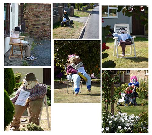
Gorgeous day for a bike ride yesterday, so headed out to uncharted territory in the Fens. Little Downham is a village of about 3,000 people, 5km north west of Ely on one of the old 'fen isles', raised land which before the Fens were drained stood up from the marsh. They're having their carnival this weekend and for this they're having a scarecrow competition: so lots of the houses have scarecrows outside:

A couple of hours surveying saw Little Downham done, so on across the fens for the other missing link in these here parts, Mepal. The journey took in the already mapped (thank you, Donald!) settlements of Coveney and Wardy Hill. And some pumpkins. (You don't often see this strange sight in fields, though it is Halloween before long). This picture is from California. Yes, that's right: California, Cambridgeshire.

See full entry

Location: Dunkirk Farm, Downham, East Cambridgeshire, Cambridgeshire, Cambridgeshire and Peterborough, England, CB6 2TY, United Kingdom

Soham and Isleham, Cambridgeshire

Posted by davidearl on 25 August 2009 in English.

I thought it was just the southern end of Soham that was missing, but no it turned out that around half the town wasn't done, including a whopping area of new housing on the northern edge. So it took me rather longer than I expected to complete Soham. Nevertheless it is done now - thanks to Donald for the larger chunk that was already complete. There's an interesting area to the east of the town called Qua Fen Common (strange name) and the similar East Fen Common, which seems to be a large tract of genuinely common land. It's well used for grazing ponies.

Then over the fen to Isleham, a village of some 2,500 people 5km east of Soham and one of the the last outposts of Cambridgeshire in the east. Isleham is known for its old priory, but I also discovered the Isleham Lime Kilns, a 19th century industrial relic in the middle of a housing estate.

By the time I got back to the bus stop for home (the last three miles across the fens into a fierce southerly wind), I was ready to stop after seven hours continuously on the bike.

Location: Soham, East Cambridgeshire, Cambridgeshire, Cambridgeshire and Peterborough, England, United Kingdom

Fordham, Cambridgeshire

Posted by davidearl on 15 August 2009 in English.

The first time in ages I have mapped anywhere that has taken me less than an hour to reach by public transport. A fairly typical Cambridgeshire village, population just under 3,000, though it was apparent from the bus up from Newmarket that there was also a lot of industrial development south of the village, which I was able to complete as well. There was a skeleton of streets in place, but only about 20% completeness previously. Fordham has a rather magnificent water tower (http://www.geograph.org.uk/photo/252313).

There's a chunk of Soham on its southern edge which is not complete, (which almost merges into Fordham), so a good combination for another day would be that plus the village of Isleham, a couple of km further east.

However, I hadn't realised that when I was there, so instead headed south and filled in a small chunk of Newmarket (off George Lambton Avenue) where housing was under construction last time I was there. It's moved on quite a lot, but there's still construction going on. But three new streets have materialized.

Location: Fordham, East Cambridgeshire, Cambridgeshire, Cambridgeshire and Peterborough, England, United Kingdom

Completed the survey of Stansted Mountfitchet which I started a couple of weeks ago. SM is a community of around 6,000 (including Bentfield to the west of the old Cambridge Road, which I did previously).

I was then intending to follow NCN11 further south, but it appears that Stansted Mountfitchet station is as far as it goes at present (there's no signs other than back along the section I'd already done) - unless anyone knows different. I had expected it would head over to Bishops Stortford and then down the Lea somewhere, but if it does there seems to be a break in the route here.

So instead I headed up the road to Elsenham, the next small village north up the railway line towards home. It had had a bit of attention, but was by no means complete - and still isn't as my batteries ran out and my train was due. Another day. It won't take more than half an hour to do; it looks like Newport, the next station north, is well underway, so perhaps the neighbouring village of Henham would be a good target for a Sunday afternoon after Elsenham is done.

Location: Stansted Mountfitchet, Uttlesford, Essex, England, United Kingdom

My final session to complete Downham Market in west Norfolk took only a couple of hours - just remaining to do were the main shopping streets and a few streets to the north, plus the area east of the centre known as The Howdale. So another substantial town crossed off the list. A couple of streets missing name signs will have to be added by someone who knows the place.

Then moved on about 7km further south to the village of Hilgay which had nothing bar the name on the map, and completed that. It took me getting on for hour so must be about 1,000 people. [Indeed - Wikipedia says 1174]

Then my plan was to head for Littleport and catch the train home. That took me to Ten Mile Bank, a village strung out along three arms of a cross roads (two of which are NCN11), so called because of the embankment which the north-south roads follow along the River Ouse between Littleport and Denver. The basic roads were in, but there are just a few short residential streets off them, and all POIs were needed. (Strangely the river road south had been duplicated on the map - someone had done an exact copy on top of the original I added when I first did Littleport more than a year ago, node for node, for 10km or so).

Seeing the train cross the level crossing in TMB and knowing they were once an hour, I thought that's just comfortable time to get to Littleport despite the strong southerly wind sweeping across the fens - except it turns out they change the timings for this one train, so because I paused to capture a tiny village of Black Horse Drove on the way, I was just coming into Littleport when the train I needed passed me. An hour to wait on windswept Littleport station. Ho hum.

See full entry

Location: Downham Market, King's Lynn and West Norfolk, Norfolk, England, United Kingdom

NCN11 Wendens Ambo to Stansted Mountfitchet, Essex

Posted by davidearl on 6 July 2009 in English. Last updated on 3 August 2009.

NCN11 came to a rather abrupt halt where I left it (actually the last mile was wrong anyway) near Wendens Ambo (Audley End Station) in Essex, so being a nice day I went for a ride to see where it went, and collected villages along the way.

It meanders through Arkesden (which I completed), Clavering (which was largely mapped, but a few streets were missing, now added), Rickling and Rickling Green, (completed, though there's no obvious street name sign for the road along the west edge of the village green or the little road on which NCN leaves the village), and Manuden (which I thought was mapped, but now I'm not so sure, so it could do with a return visit).

Then into Bentfield (Bentfield Bower, Bentfield Green) which now merges with Stansted Mountfitchet, a much more substantial village on the old London to Cambridge road (and, yes, very close now to Stansted Airport). Lots of residential to do here, so ran out of time after completing the area west of the B1383.

NCN11 continues east out of Stansted, who knows where, and is a natural trip to complete S.M. and continue out along NCN11.

Location: Stansted Mountfitchet, Uttlesford, Essex, England, United Kingdom

Kings Lynn, Norfolk: North Lynn

Posted by davidearl on 28 June 2009 in English.

There were only three of us for the King's Lynn mapping party, so it looks like we'll need to have another go. We probably did about 30% of the town (it looks more on the map because someone had already sketched in the road network without names, from a source of unknown origin).

My bit was North Lynn, which is completed essentially to the west of NCN1. After a grey start, turned into a bit of a hot sticky afternoon working round industrial estates and rather poor housing - the kind of area that has CCTV cameras on many of the residential street corners!

Location: North Lynn Allotments, North Lynn, King's Lynn, King's Lynn and West Norfolk, Norfolk, England, United Kingdom

Furness Vale, Derbyshire

Posted by davidearl on 28 June 2009 in English.

Had an evening to spare visiting east of Stockport so extending the mapping I'd already done further west to the village of Furness Vale on the main A6 road between Whaley Bridge and new Mills. There was already some detail there, but I was able to add most streets (still the odd one to do). I was tediously slow on foot, but I hadn't brought my folding bike with me.

Location: Whaley Bridge, High Peak, Derbyshire, East Midlands, England, United Kingdom

Second trip to the market town of Downham Market between Cambridge and King's Lynn. Firstly dealt with a couple of bits I'd missed in the south last time (including a well hidden nature reserve) and then mostly housing estates north of the town centre, including a vast area of new housing to the east of the main road out towards King's Lynn and another big new chunk near the station. The 2001 census said ~7,000 people but I reckon these new houses must add maybe 3,000, perhaps more - much more than I thought, and partly the reason I didn't have time to complete the town this time - the centre and a small area to the west of Lynn Road is still missing. I'll go back shortly and that will also give me time to do the village of Hilgay, on the way back south towards Ely. I also got a bit sidetracked tot he north with the village of Wimbotsham, which I completed.

Location: Downham Market, King's Lynn and West Norfolk, Norfolk, England, United Kingdom

Started work on the town of Downham Market, a half hour train ride north of Cambridge. Downham is about 7,000 people (well, 2001 census, so it's probably more now), so one or two more sessions should do it - though I got a bit side-tracked this time away from the endless bungalows of the southern outskirts of the town, into Ryston Hall estate and related hamlet, Fordham hamlet (where I got lost among farm tracks which didn't go where I expected) and mainly the delightful village of Denver which among other things has a working windmill with a welcome tea-room-cafe for a hot afternoon and the Denver Sluice complex (south west of my marker). That is a major piece of flood and water engineering where the tidal River Ouse and the parallel major flood relief drain out to the Wash are linked to the southern river network along the Bedford levels. There's a broad canal called the Cut Off Channel which according to the signs used to drain into the Relief Channel through one of the three huge sluices but has now been closed and the flow reversed so that water runs many kilometres south east to Barton Mills near Mildenhall where it is pumped through a 40km tunnel and on to Essex to quench the thirst of its inhabitants. There's also a deep lock in the middle of the complex to carry boats from the upper river into the Relief channel - though curiously there's no connection into the Bedford rivers - you'd have to go down to Ely and across to Earith to get back to the bottom of the western sluice.

Location: Downham Market, King's Lynn and West Norfolk, Norfolk, England, United Kingdom

Bury St Edmunds essentially completed! This city of 40,000 was 70% mapped by a mapping party last year, but we didn't manage to finish it. Now, three trips this year later on it is now done to road/cycleway/POI level.

I also managed to pin down the tortuous courses of NCN13 and 51 through the eastern suburbs - its weird, they start off together, divide and then cross over. Not at all the obvious route IMO, even with the desire to keep it off road.

As it only took me a couple of hours to finish the easterly outskirts (much of which is an inaccessible building site - so will need revisiting in a year or so - probably longer if the building has ground to a halt), I then went on a rural jaunt along NCN13 to see where it goes and mapped the small but spread out villages of Rougham and Hessett. Caught the train back from Thurston so was able to add the Rougham Industrial Estate and the western part of Thurston village, which is a bit bigger than the other two, and lies on NCN15.

Location: Bury St Edmunds, Suffolk, England, United Kingdom

Completed Brampton, near Huntingdon, Cambridgeshire, on Friday. That's the last bit of the Huntingdon conurbation of some 30,000 people including Godmanchester and Huntingdon itself that I've been working on on-and-off since the late summer last year. In fact there wasn't as much left to do as I thought so I then headed off along NCN12 towards Grafham Water. Unfortunately I hadn't updated the map on my Nokia so I mapped Grafham village only to find it had been done very thoroughly already. Not that it is a huge place, so not much time wasted =, and it was a nice day anyway. Then round to the south shore and the village of Perry, which had a few streets done, but was only about 20% complete. Now 100%.

By then I was half way to St Neots so I though I might as well continue with NCN12 southwards and get the bus back from St Neots instead of Huntingdon. Big mistake. The 200m or so south of Grafham Water is a joke - it is a grassy muddy narrow excuse for a cycle path that Sustrans should be deeply ashamed of. So bad was it that if the crud hadn't given me a puncture, I'd have had to have taken the wheel off anyway to clear out the hard packed mud that was stopping the wheel going round. And then there were crucial signs missing that meant at one point I ended up on the A1 and with a half hour diversion. And naturally, it had already been mapped, but I didn't have the map on my display to follow. Then the bus was half-an-hour late. Cycling the National Cycle Network ought to be a pleasurable experience. On Friday it was the opposite.

Location: Perry, Huntingdonshire, Cambridgeshire, Cambridgeshire and Peterborough, England, United Kingdom

One of those generally dull housing estates, retail parks and industrial estates you find on the edge of so many towns and cities these days, the Moreton Hall area of Bury St Edmunds was once outside the town, the estate of an old country house now and for some time a private prep school. Indeed I remember it from the late 70's when I helped to run a children's holiday there during the school vacation, when it was fields all around. There's still a few fields left, which was a relief as there was less blank on the map than I had feared. Nevertheless Bury will still require at least on more visit to complete. I did discover the routing of NCN13 out to the east of the town, however. Remaining section is north of Skyliner Way and south of the railway on the extreme eastern edge of town.

Location: Bury St Edmunds, Suffolk, England, United Kingdom

Bury St Edmunds, Suffolk - south central

Posted by davidearl on 22 February 2009 in English.

Completed Bury St Edmunds central area - everything within the ring road south of Abbeygate Street (north of there was already done) and west of the A14, plus a few missing bits to the south east. Then made a start on Moreton Hall, but didn't get further than doing Sainsburys and most of the retail park. Among the notable features is the huge Greene King brewery which dominates the southern end of town.

Location: Bury St Edmunds, Suffolk, England, United Kingdom

Longstanton by-pass, Cambridgeshire

Posted by davidearl on 9 February 2009 in English.

A substantial new bypass opened recently around the village of Longstanton north of Cambridge. A friend on a bike ride collected the track yesterday so I was able to take his track and description and add it to the map. As far as we know, it's not on any other online map so far.

http://geo.topf.org/comparison/index.html?mt0=googlemap&mt1=tah&lon=0.0459194&lat=52.2827571&z=14

(By the way, the big chunk of green on the Google side labelled bizarrely 'Cambridge' is a golf course, which we have on the map at the club house, but not the area; the roads south of that are private: part of an barracks, a "prohibited area under the meaning of the official secrets act", which is now a detention centre for refugees with armed guards on the gate, so I chose not to try to map it when I first surveyed Longstanton! Google is perhaps misleading in even showing these - they look like residential streets, but are inaccessible.).

Interestingly, Google doesn't even have the "old" bypass (the rather obvious gap between two roundabouts) that preceded the new one further out, and which has been there for several years now

This bypass severs NCN11 - there are now earth bunds and locked gates along the line of the old road, which was a quite senseless decision. NCN11 is now routed along the main street of the village and along the new high-speed by-pass. Crazy. However, this may only be short term, as the whole of NCN11 will be rerouted to use the entirely off road cycleway alongside the Cambridgeshire Guided Bus between north Cambridge and St Ives at the end of this year (it's delayed).

Location: Longstanton, South Cambridgeshire, Cambridgeshire, Cambridgeshire and Peterborough, England, United Kingdom

After about 6 weeks without doing any surveying, due to minor ailments and other commitments, got out again yesterday to complete the large village / small town of Godmanchester near Huntingdon. The central bit is a nice change from the housing estates. It's on a branch of the River Great Ouse and the wharf comes right up to the main street.

Having finished Godmanchester, on to Brampton, another large village near Huntingdon, about 6km bike ride away to the north-west of Godmanchester. It's had a bit of work already, but as I suspected from Landsat and the population figure, what was there only scratched the surface. I checked what was already there and then did the large residential section to the west of the village centre. The light and my battery failed at just about the same time and the temperature plummeted so a clear signal to stop, but I think there's less than an hour's remaining surveying to do - the village green and an area to the south and west of the green. A long round trip just to do that isn't worth it, so it looks like I need to find another place nearby to continue with - looks like Buckden a few km to the south is the next likely target.

Location: Wyboston Farm, Godmanchester, Huntingdonshire, Cambridgeshire, Cambridgeshire and Peterborough, England, PE29 2LD, United Kingdom

Royston (north-east), Hertfordshire

Posted by davidearl on 5 December 2008 in English.

Turned up at Cambridge railway station to take the first train to unmapped territory. That happened to be Royston, the north-east quadrant. Sadly this was surveyed in the summer, but the person who did it lost interest and never did the data entry. So I resurveyed it today and added the data. That means my earlier assertion that Royston was complete to street/poi level now really is true.

Also popped up the A1198 from the north edge of Royston to join up with previously surveyed Bassingbourn about 2km further north, just to check nothing missed in the gap between - and there was indeed a short residential street off that road which was outside the village, so I'd missed it before.

Location: Royston, North Hertfordshire, Hertfordshire, England, United Kingdom

Weather forecast bright and sunny for yesterday, but betrayed: it was lowering clouds and lots of drizzle and rain, not the most pleasant day for mapping. I thought I'd get off the bus before St Ives and bike across NCN51 for a 4 miles or so to continue mapping Godmanchester (a big village just south of Huntingdon), rather than spend another 40 minutes on the bus winding through St Ives and Huntingdon. However as I set of through Hemingford Grey I realised what I thought was a completely mapped small village was in fact a much larger village of which only about 20% was on the map. So I got diverted and mapped that and Hemingford Abbots, including a grade separated junction onto the A14 almost-a-motorway road that had been missed out completely, much to my surprise.

That didn't leave a lot of time by the time I did reach Godmanchester, so I only managed to do the huge distribution depot/industrial park alongside the A14 and a boring large area of new housing on the south-western edge of the village, the kind of place where every street looks the same. Getting dark and wet by 4pm, so time to give up. Bus failed to turn up on the road out of St Ives so had to wait 40 mins in the cold and wet.

So, still another trip required to complete the central section of Godmanchester and then to start on the next large village of Brampton.

Location: Gore Tree Farm, Hemingford Abbots, Hemingford Grey, Huntingdonshire, Cambridgeshire, Cambridgeshire and Peterborough, England, PE28 9HQ, United Kingdom

Two men went to mow...

Posted by davidearl on 20 November 2008 in English.

Cambridge's latest Park & Ride site opened last Saturday. I really needed a map of it (don't ask!) so in major drizzle and on the bleak windswept edge of the fends our intrepid hero went to map essentially a huge car park. Brought the tracks home, and what's this: parts of the car park appearing before his very eyes? Has someone added psychic thought inference to the system? No, someone else (comsomol) had exactly the same idea at pretty much the same time. A few minutes different and we'd have bumped into each other navigating round the car park. Ho hum.

Location: Milton, South Cambridgeshire, Cambridgeshire, Cambridgeshire and Peterborough, England, United Kingdom