OpenStreetMap logotipas OpenStreetMap

davidearl dienoraštis

Paskutiniai dienoraščio įrašai

Pilgrimage to Newlyn

Parašė davidearl, laikas 2013 08 01, kalba English.

I visited the west of Cornwall for the first time in July. So I had to make a pilgramage to Newlyn (location). Newlyn is the Ordnance Datum for Great Britain, the zero height mark for the whole country. I thought there would at least be a plaque or notice, but no, there’s no indication at all. I had to ask in the harbourmaster’s office, where an archetypical gum-booted seaman told me that tourists often ask about it and he was surprised there was nothing to show for it. It is located at the end of the southern pier to the harbour, which is inaccessible; but I could get out to the end of the north pier opposite and take this photo.

Newlyn zero datum

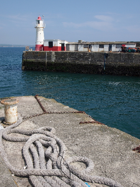
I gather the red and white hut next to the harbour light houses equipment to support this, and you can see a cable leading from it down into the sea. The Ordnance Survey site suggests there is a marker bolt, but I can’t see it. It may be below the current sea level.

There needs to be an information board or something.

See full entry

Vieta: Trevithal, Paul, Penzance, Cornwall, England, TR19 6UQ, United Kingdom

The University of Cambridge today launched its new responsive web site design, and its map, based on OSM and originally released last September, was part of this. My previous diary entries talk about the development of the map using OSM.

However, the map update was more than the design, and an API revision. It introduces a new facility to mark your own features in an overlay on top of the map. Want to let someone know where to meet? Or how to reach you from the station? Where will our new building be? Draw it on the map and send a link.

While the drawing facilities aren’t particularly novel - you can draw points (which can have text and an image linked to them), lines and areas, and style these - what makes it a bit different from some other map annotations is that there isn’t a database behind it. The editor creates (and edits) files, and the link you can send is a combination of two URLs. So it’s a bit like KML, though actually we chose a JSON format. But because you can put the file at any URL, they don’t have to be simple files generated by the editor: they can be scripted, so other formats and data sets can be overlaid (so KML or GPX or extracts from OSM XML files could be converted as an overlay on the fly, for example, though we haven’t done that yet).

For example, we can overlay the University data cabling network (called the Granta Backbone, comprising a hundred miles of ducting across the whole city and dozens of inspection chambers and terminal junctions) on the map, from a protected overlay (sorry, it is not public data, so I can’t show you this). Another overlay seeks out the college staircase entries from OSM data and creates dynamic overlays from these. It has also allowed us to translate links from the old University map (which were pixel offsets onto a set of fixed images).

See full entry

University of Cambridge map now live

Parašė davidearl, laikas 2012 10 02, kalba English. Paskutinį kartą atnaujinta 2012 10 03.

I am pleased to say that the University of Cambridge’s new online map is now live, at http://map.cam.ac.uk , and linked off the University’s home page at http://www.cam.ac.uk .

This is the outcome of Project Drake, started a year ago. Surveys were conducted, with the data going into OSM. The data is rendered to a custom style loosely based on a previous non-OSM one. There is a database of the OSM data to support street name and third-party location searches and a database of institutional contact details. The two are loosely linked using the ref tag so that the university database can determine where an institution is located geographically. There is an API; and a separate presentation on small screen devices.

A paper map is also in final draft form.

There is some background the project here: osm.org/user/davidearl/diary/15398 and here: osm.org/user/davidearl/diary/17050

The University’s Computing Service has published a news release, here: http://ucsnews.csx.cam.ac.uk/articles/2012/09/24/new-university-map-launched

See full entry

Update on Project Drake, mapping the University of Cambridge

Parašė davidearl, laikas 2012 06 10, kalba English. Paskutinį kartą atnaujinta 2012 12 28.

Back in December I blogged about Project Drake, to map the University of Cambridge. Surveying for this has proceeded steadily over the last eight months (April was somewhat wet, as you know, but apart from that all went pretty smoothly). With the recent upload of data for Trinity Hall, Trinity College and their outliers, it is now essentially complete: 31 colleges, ~10 campus-like sites, several thousand buildings.

The Colleges, which are all independent of the University, and Addenbrooke’s Hospital where several University departments are based and more properly now known as the Cambridge Biomedical Campus, have all kindly co-operated in allowing access for surveying, and the University has provided most of the survey data to OSM so it is both a provider and consumer of data. The software will be released under GPL shortly.

I am currently putting the finishing touches to a custom rendering (which goes down to zoom 19, about 1:1,500 on a typical monitor with 45m map tiles, but just for the University area, about 8 square kilometres) using its existing map style as a starting point. These are provided via a slippy map, an API (JSON) and iframe embedding for third-party sites, a dynamic search index, and artwork for a paper map (at 1:7,500). The website isn’t publicly available yet, but we have http://map.cam.ac.uk reserved for it. We hope there will be a “productisation” phase next (the current exercise is formally a “feasability study”).

See full entry

Vieta: Newnham, Cambridge, Cambridgeshire, Cambridgeshire and Peterborough, England, CB3 9LA, United Kingdom

Satellite Pictures - they must be true! NOT.

Parašė davidearl, laikas 2011 12 05, kalba English.

I think it's very tempting to believe satellite imagery, to give it more credence than it deserves and to tweak things to match the satellite.

Project Drake to map the University of Cambridge (see osm.org/user/davidearl/diary/15398 ) involves micro-mapping University buildings. I'm aiming at typical GPS accuracies in doing this, but in areas where there is little or no GPS signal, so I have been measuring things on the ground with a laser measure. In principle this can give sub centimetre accuracies, but of course it is still subject to errors of various kinds (mostly human error or inaccessibility) which also accumulate. Nevertheless it is very accurate and in principle I ought to be able to get accuracies of a metre or so. And incidentally, it is gratifying to note that real distance measures in JOSM are extremely accurate: i.e. correspond very closely to accurate measurement on the ground.

But there are numerous sources of inaccuracy in the satellite pictures that I wasn't necessarily expecting, not having used them in areas of tall buildings before, which leads me to say that it is not wise to put too much faith in them, especially when you're down at metre level accuracies.

1. The obvious one. They are out of date. In Cambridge, sometimes very out of date. Not surprising that the University's Alison Richard building isn't there (opened last week), but the Gonville & Caius' Stephen Hawking building and vast swathes of Selwyn College are missing. More surprising, adjacent Bing tiles differ considerably in their vintage. To the extent that on one site I surveyed half a (not all that) new building appeared on one tile (completed, no sign of construction work) but the other half wasn't on its neighbour at all.

See full entry

Cambridge University comprises around 200 faculty, departmental and related institutions on 10 or so sites (several of which are rabbit warrens of building over centuries) and distributed in and around the whole city of Cambridge. It shares a biomedical campus with Addenbrooke's Hospital currently expanding by 50% and most years see several new buildings erected and departments move premises.

The University manages over 700 properties. It has 31 independent colleges each of which occupies sometimes two or three sites around the city and a few of which are as large as an entire campus University. It has over 17,000 students and over 9,000 staff (not counting those employed by colleges) and innumerable visitors.

They all need to find their way around.

So, since September, on behalf of the University's Computing Service, I have been cycling and walking around all the University and College properties, measuring and photographing, and entering the data into OpenStreetMap with a view to potentially replacing the University's existing online ( http://www.cam.ac.uk/map/ ) and paper maps. This is code-named 'project Drake' and continues until June 2012. It is a feasibility study, but the hope is that it will be proved sufficiently feasible that it can become a live system.

Of course, quite a lot of the University is already in OSM. Some colleges are already mapped down to individual trees; others are just an outline of the perimeter. Some University sites were missing altogether; others had been traced from satellite with no additional information and had errors that you might expect when viewing entirely vertically.

See full entry

Vieta: 52.202, 0.110

@osmblogs

Parašė davidearl, laikas 2010 12 09, kalba English.

I have created an automatic twitter feed from the RSS feed of the aggregated osm blogs, under the twitter name @osmblogs.

Of course you could follow it on twitter, but the main reason I did this is so that the combined blogs can be used as a source for flipboard on the iPad.

(if anyone did something similar already, sorry, I didn't know)

Whittlesey, Cambridgeshire

Parašė davidearl, laikas 2010 04 19, kalba English.

(I haven't posted a diary entry for a while, but I have been busy over the winter as part of a hardy team of six that braved the ice and fen winds to map Wisbech and a large part of rural Fenland. I'll come back to that later as there's more to it than just the surveying).

However, moving on, Whittlesey (aka Whittlesea) is a small market town half an hour's bike ride SE of Peterborough. At 16,000 (2001 census) it is by far the largest settlement in Cambridgeshire not yet mapped and when complete will bring Cambridgeshire to around 97% complete (the next largest place is Ramsey, which another Cambridgeshire regular has done most of now too, and after that we're into villages with up to 2,000 people, mostly a few hundred, west of Peterborough).

So two of us headed to Whittlesey weekend before last and the data is going in now. It'll take another session to complete the town. Anyone who has gone by train between Peterborough and Ely will know Whittlesey from its brick works. The old chimneys are now complemented by an equal number of wind turbines. The town itself is nothing to write home about, though it has a pleasant market square in the middle. Like a lot of places, it's like an onion with layers of houses from recognizable periods. And to go with the onion, it is also home to a McCain foods factory, of Oven Chips fame.

NCN63 (which had already been added) passes through the town on its way from Peterborough to March.

Vieta: Whittlesey, Fenland District, Cambridgeshire, Cambridgeshire and Peterborough, England, United Kingdom

Great Shelford, Cambridgeshire minor updates

Parašė davidearl, laikas 2009 10 30, kalba English.

Had to go to the dentist today which took me to Great Shelford. Someone had noted a missing street on openstreetbugs so I went looking for it. Sure enough it was there, but no wonder I missed it - Glebe Lane it was and it looks just like a private driveway. I also found a small new development since my original survey and another, Abberley Wood (not Woods as the developer's sign says) that I knew about but had since opened up (still a bit more to do when they complete it).

Vieta: Great Shelford, South Cambridgeshire, Cambridgeshire, Cambridgeshire and Peterborough, England, United Kingdom

Fulbourn, Cambridgeshire: house numbering #4

Parašė davidearl, laikas 2009 10 18, kalba English.

Fulbourn now completely house numbered. (Fulbourn village that is: there is a actually a section of Fulbourn parish that is actually connected to Cherry Hinton which I suppose I ought to do, but then it'll look odd that Cherry Hinton's not been done and then it would look odd that the rest of cambridge hasn't been done, ... - and there's places to map from nothing elsewhere in Cambridgeshire before that).

No great surprises this time, though a street name was missing. The construction site in the middle of Fulbourn is moving westwards - many of the old houses are now empty ready for demolition, and I didn't number those.

Vieta: Fulbourn, South Cambridgeshire, Cambridgeshire, Cambridgeshire and Peterborough, England, United Kingdom

Fulbourn, Cambridgeshire: house numbering #3

Parašė davidearl, laikas 2009 10 12, kalba English.

85% of houses now numbered in Fulbourn, this time the eastern edge of the village, one more little local excursion should finish it. For my record, remaining bit is south: Cambridge Road, Shelford Road, Huntsmill; what streets are still left in the construction site off Cambridge Road; and School Lane, Ludlow Lane and also check corner of Home End/Ludlow Lane.

Fulbourn was one of the first places I surveyed, more than three years ago, and this re-survey reveals quite how much detail I didn't include when staring out that I would now collect. Also another two whole new streets gone up recently found and a cemetery discovered that I didn't know was there. The Fulbourn Centre (community centre) and recreation ground had virtually no detail before.

Also, someone doggedly shifted lots of streets in Fulbourn about six months ago to match the Yahoo images. This re-survey with a different GPS confirms the GPS was right (they match) and the shape of the streets had been altered incorrectly, so I was able to make some corrections there, St Vigors Road was especially bad. Also the satellite images are now rather out of date for the development that has happened recently.

Vieta: Fulbourn, South Cambridgeshire, Cambridgeshire, Cambridgeshire and Peterborough, England, United Kingdom

Kimbolton and neighbours, Cambridgeshire

Parašė davidearl, laikas 2009 10 11, kalba English.

In Cambridgeshire terms, a bit like an uncharted backwater in the western spiral arm of the galaxy. Neverthless a little corner of the county bordering on Bedfordshire and Northamptonshire that was missing from the map.

It didn't used to be like that. Kimbolton used to be on the main A45 road from Ipswich to Birmingham via Cambridge and Northampton. The A14, a motorway in all but name a few miles to the north took all the heavy traffic away a few years ago, though the now B road along the Kym valley is still surprisingly busy. But the many-times-repaired wall on the extremely sharp and narrow corner of London Road shows the scars of quite how much of a bottle neck this must have been.

Kimbolton is pretty village, having more the feel of a small town really though the population can't be more than 2,000, dominated by Kimbolton School, an independent school based around a grand stately home with parts designed by Robert Adam. The High Street is especially grand, about 25m wide and almost a town square - leading up to the gates of the school - a bit like Marlborough in Wiltshire or Appleby in Cumberland. No less than two tea shops, excellent news for a thirsty mapper on a warm day, and a couple of up-market delicatessens, an old fashioned independent electricals store and an even older gents outfitters - it's a wonder they survive, though rich parents and students at the School no doubt bring a lot of money into the village.

On the way out from the bus at St Neots, paused to map Great Staughton, a dull little village. Kimbolton, being smaller than expected, left time also to map the next small village west, Tilbrook, and Kimbolton's immediate neighbour, Stonely. I also climbed a long hill out of the valley following Industrial Estate signs, only to find when I got home that someone had already mapped it, oops. Conversely I see I should have taken a small detour via a hamlet called Dillington on the way back for completeness.

See full entry

Vieta: Kimbolton, Huntingdonshire, Cambridgeshire, Cambridgeshire and Peterborough, England, United Kingdom

About 70% of Fulbourn now numbered. It's a slow, tedious business, house numbering, but it's handy for an hour or two on a Sunday afternoon, as it is on my doorstep and there's nowhere now nearby that is unmapped that is worth spending less than a whole day out mapping because of the travel time overhead.

I found another whole new street (The Swifts) has been built since originally mapped, and I discovered some more branches of one street (Cox's Drove) I'd missed previously because they just looked like driveways, but actually led to several groups of houses.

Vieta: Fulbourn, South Cambridgeshire, Cambridgeshire, Cambridgeshire and Peterborough, England, United Kingdom

Fulbourn, Cambridgeshire: house numbering

Parašė davidearl, laikas 2009 09 27, kalba English.

I did some serious house numbering for the first time today, using the Karlsruhe Schema around my own home. I quickly realised it is a whole different way of mapping. If I'm going to do it on a bike, I need to find a way to attach a clipboard or something with easy access. I need to print out walking papers at a much higher zoom than I did as there's not enough room to write in the numbers at the scale I did it. And I need to collect tracks because hammer-head ends that I might not originally have marked become much more significant, and things change from the original survey and I need waypoints to mark changes in the numbering (e.g. a missing number) when there is no physical reference to pin it to on the existing map. It's sloooow work to get it right though. I'm sure I'll speed up, but I'm not going to try it everywhere, I'll just do it for my village for now.

And I did find changes: within 200m of my house, a new housing estate has been built. Now I knew that had happened, but what I didn't realise is that they had realigned the street pattern and changed street names when they demolished the old houses and built the new. Moral: always worth checking on the ground.

Vieta: Fulbourn, South Cambridgeshire, Cambridgeshire, Cambridgeshire and Peterborough, England, United Kingdom

Warning: this post contains tagging challenges!

Gorgeous day for a bike ride yesterday, so headed out to uncharted territory in the Fens. Little Downham is a village of about 3,000 people, 5km north west of Ely on one of the old 'fen isles', raised land which before the Fens were drained stood up from the marsh. They're having their carnival this weekend and for this they're having a scarecrow competition: so lots of the houses have scarecrows outside:

A couple of hours surveying saw Little Downham done, so on across the fens for the other missing link in these here parts, Mepal. The journey took in the already mapped (thank you, Donald!) settlements of Coveney and Wardy Hill. And some pumpkins. (You don't often see this strange sight in fields, though it is Halloween before long). This picture is from California. Yes, that's right: California, Cambridgeshire.

See full entry

Vieta: Dunkirk Farm, Downham, East Cambridgeshire, Cambridgeshire, Cambridgeshire and Peterborough, England, CB6 2TY, United Kingdom

Soham and Isleham, Cambridgeshire

Parašė davidearl, laikas 2009 08 25, kalba English.

I thought it was just the southern end of Soham that was missing, but no it turned out that around half the town wasn't done, including a whopping area of new housing on the northern edge. So it took me rather longer than I expected to complete Soham. Nevertheless it is done now - thanks to Donald for the larger chunk that was already complete. There's an interesting area to the east of the town called Qua Fen Common (strange name) and the similar East Fen Common, which seems to be a large tract of genuinely common land. It's well used for grazing ponies.

Then over the fen to Isleham, a village of some 2,500 people 5km east of Soham and one of the the last outposts of Cambridgeshire in the east. Isleham is known for its old priory, but I also discovered the Isleham Lime Kilns, a 19th century industrial relic in the middle of a housing estate.

By the time I got back to the bus stop for home (the last three miles across the fens into a fierce southerly wind), I was ready to stop after seven hours continuously on the bike.

Vieta: Soham, East Cambridgeshire, Cambridgeshire, Cambridgeshire and Peterborough, England, United Kingdom

Fordham, Cambridgeshire

Parašė davidearl, laikas 2009 08 15, kalba English.

The first time in ages I have mapped anywhere that has taken me less than an hour to reach by public transport. A fairly typical Cambridgeshire village, population just under 3,000, though it was apparent from the bus up from Newmarket that there was also a lot of industrial development south of the village, which I was able to complete as well. There was a skeleton of streets in place, but only about 20% completeness previously. Fordham has a rather magnificent water tower (http://www.geograph.org.uk/photo/252313).

There's a chunk of Soham on its southern edge which is not complete, (which almost merges into Fordham), so a good combination for another day would be that plus the village of Isleham, a couple of km further east.

However, I hadn't realised that when I was there, so instead headed south and filled in a small chunk of Newmarket (off George Lambton Avenue) where housing was under construction last time I was there. It's moved on quite a lot, but there's still construction going on. But three new streets have materialized.

Vieta: Fordham, East Cambridgeshire, Cambridgeshire, Cambridgeshire and Peterborough, England, United Kingdom

Completed the survey of Stansted Mountfitchet which I started a couple of weeks ago. SM is a community of around 6,000 (including Bentfield to the west of the old Cambridge Road, which I did previously).

I was then intending to follow NCN11 further south, but it appears that Stansted Mountfitchet station is as far as it goes at present (there's no signs other than back along the section I'd already done) - unless anyone knows different. I had expected it would head over to Bishops Stortford and then down the Lea somewhere, but if it does there seems to be a break in the route here.

So instead I headed up the road to Elsenham, the next small village north up the railway line towards home. It had had a bit of attention, but was by no means complete - and still isn't as my batteries ran out and my train was due. Another day. It won't take more than half an hour to do; it looks like Newport, the next station north, is well underway, so perhaps the neighbouring village of Henham would be a good target for a Sunday afternoon after Elsenham is done.

Vieta: Stansted Mountfitchet, Uttlesford, Essex, England, United Kingdom