Today is the anniversary of my first changeset, according to http://www.hdyc.neis-one.org/, so I thought I’d write my first diary article. I’ve spent most of my time mapping in the Peak District National Park in the UK and I thought it would be good to produce an image of this as a record of progress to date. The image below was produced with Maperative and I wanted to have it as a record of the progress made in mapping field boundaries, so these have been highlighted. Paths and tracks are also marked. Unfortunately I didn’t know how to produce such a record when I first started so it is difficult to know how the map has actually changed but my general impression was that there were very few field boundaries mapped a year ago in this area. The image only covers the SE part of the Peak Park as this is where I have been concentrating my mapping activities to date.
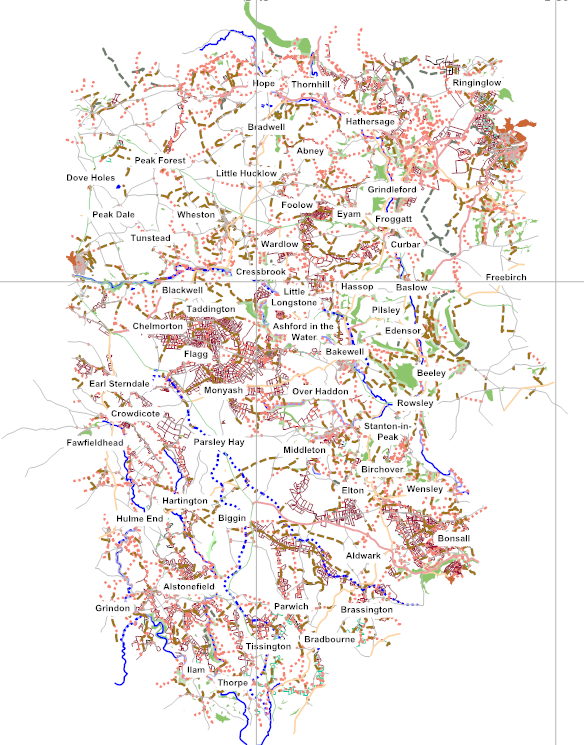
Sometimes it has felt like a very daunting task and looking at this there are still a large number of white areas, where there are no field boundaries mapped to date. It will be interesting to see how it looks in a year’s time. It is a bit of thankless task mapping so I would like to thank those that had already added many maps features in this area and continue to do so. If you hadn’t I wouldn’t have put an OSM map on my Garmin GPS and then found it wasn’t as detailed as I’d have liked. So your work has inspired the above. Hopefully it will inspire others to add more field boundaries this summer so we can produce a really good walking map of the Peak District National Park.
讨论
Tom Chance 于 2013年02月22日 09:48 的评论
From one OSM contributor to another… thanks!
This looks like really good work.
Richard 于 2013年02月22日 17:11 的评论
Seconded - nice work!
Tom Chance 于 2013年02月25日 09:19 的评论
Actually, I was in the Peak District this weekend walking around Tissington and Matlock. Having OsmAnd on my phone certainly impressed friends who were staring blankly at Google Maps trying to work out where to go. So thanks.
I noticed lots of little paths around the tors/hills between Matlock and Matlock Bath that need adding in, if anyone fancies a nice day’s work. Sadly I couldn’t divert my friends in circles to get them all, and currently there’s only one footpath mapped.
SimonRedding 于 2014年05月19日 14:43 的评论
Superb mapping - happened to need a map of Birchover and zoomed in, expecting to find a road and nothing else. Every house was there, every footpath and even the names of the pubs/shop. Great work…