Namefinder and OSM now starting to working in the OAD
Parašė h4ck3rm1k3, laikas 2010 02 14, kalba English. Paskutinį kartą atnaujinta 2010 02 15.Have made progress on the openaddress database.
now I can display an OSM openlayer and use the namefinder.
Next will be to do that for each line in the address database when you click on it.
This uses the geonames database,
the url looks like :
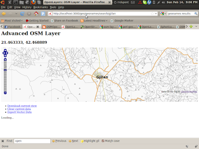
The Uril looks like this :
HOSTNAME/geo/geonames/search/gjilan
Blog Post here:
http://osmopenlayers.blogspot.com/2010/02/namefinder-with-osm-map.html
This takes lat lon and display :

The url looks like this:
HOSTNAME/openlayers/basic/42.2138889/20.7397222/
here is the blogpost:
http://osmopenlayers.blogspot.com/2010/02/simple-openlayers-controller-for.html
The source for all parts is here :
http://github.com/h4ck3rm1k3/OAD-Open-Address-Database
you can start the start like this :
cd OAD/OAD-Open-Address-Database/OAD
perl ./script/oad_server.pl
Diskusija
Naudotojo !i! komentaras, parašytas 2010 m. vasario 15 d., 07:26
SO in short, what does this mean?
Sry but I can't see anything on the screenshots :(
Naudotojo h4ck3rm1k3 komentaras, parašytas 2010 m. vasario 15 d., 07:42
Thanks,
I have updated it and added more comments and links.
mike
Naudotojo h4ck3rm1k3 komentaras, parašytas 2010 m. vasario 15 d., 11:34
I have added the ability to upload and view text files. Now will start to add a geocoding feature to them.