OpenStreetMap logo OpenStreetMap

h4ck3rm1k3's Diary

Recent diary entries

Convert web site from google maps to openlayers API

https://www.getafreelancer.com/projects/524534.html

Description
We are the owner of the website mail-virtuel.com. This web site is mainly built on google maps and Yahoo YUI APIs.
We want to convert this website to openlayers and prototype.js APIs.

As input, We'll give you the source files: php, javascript, mysql DB. The source files are self documented with almost no comments, however the code is quite clear and variables and functiosn names are mostly in english.

We need a javascript expert which is able to give us approximately the same website with the new techno mentioned above, so it's main asset must be autonomy. We'll assist you through chat to start the project: install database and website on your local server and to explain you the services available on the website. the website is in french but knowledge of french is not mandatory as you'll never need to write in french and the web interface is mainly graphical.

the maps used on mail-virtual.com are self made and you'll not have to modify them.

we really needs an applicant which is able to write clean javascript and before giving our source files, we'll ask you to build a small mockup with openlayers and Prototypes.js.

The deadline is november 20 2009. We'll not pay in advance, we'll pay you the 20 november after the job was done and checked.

we're fair and wants to start a long term collaboration

thanks

merger in effect

Posted by h4ck3rm1k3 on 12 October 2009 in English.

Hi, after doing all types of fun things,
I finally got the motivation to work on the cleanup work for kosovo.

http://bazaar.launchpad.net/~kosova/+junk/openstreetmapkosova/revision/86

Script is easy to use
perl mergenames.pl todo2.osm > deletes3.osm

Just pipe an osm file in, and it produces a file for josm out.

you can then load that in an upload to osm..

Added the feature today to round the lat/long like this
that way it merges more nodes that are only marginally different.

## now we round the coords to merge them!
$long =sprintf ("%3.5f",(($node->{header}{lon} * 1000000) / 1000000));
$lat =sprintf ("%3.5f",(($node->{header}{lat} * 1000000) / 1000000));

Thanks,
mike

Photos for tagging online

Posted by h4ck3rm1k3 on 4 October 2009 in English.
Location: Prizren, Jeni Mahalla, Prizren, Municipality of Prizren, District of Prizren, 20080, Kosovo

http://fmtyewtk.blogspot.com/2009/10/where-is-butovac.html #kosovo #osm #openstreetmap where is butovac? Why is it listed 3 times?

Please help!

We have three villages named Butovac around the Butovac mountain east of Prishtina,
does anyone know if this data is right?

http://en.wikipedia.org/wiki/Bukovac

The name Bukovac is thought to be derived from the word for a tree - 'bukva' ('beech'). The legend says when first settlers settled where now village's center is, there was an old beech so they named the place Bukovac upon that tree. There are also villages named Bukovac in central Serbia and in former Yugoslav republics.

Map of the area:
osm.org/?lat=42.6595687866211&lon=21.2372589111328&zoom=13

the nodes are here :
osm.org/browse/node/448712046

Lat/Long 42.660833, 21.250833 with the geonameid = 830024

and here
osm.org/browse/node/448573966

geonameid = 830045
name = Butovac
Coordinates:
42.6883333, 21.2238889

Now also we have another town listed as
Vujanov Mahala and as Butovac.
osm.org/browse/node/453340575

geonameid = 832739
name = Butovac
name:sr = Vujanov Mahala
Coordinates: 42.679722, 21.253889

Location: Grashticë, Municipality of Pristina, District of Prishtina, Kosovo

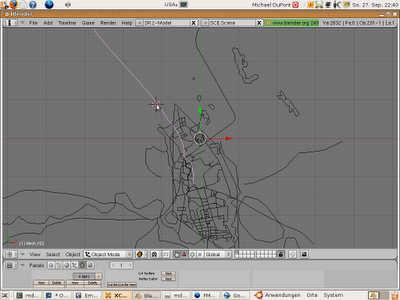
I have now been able to create rendering in blender of OSM.
more to come.

Blender faces added to the meshes

I have now added faces to the meshes imported so you can see the streets imported.

CODE:
ALL CODE IS CHECKED IN!
https://code.launchpad.net/~kosova/+junk/openstreetmapkosova

The code I added to create the faces:
create a face across the last 3 points in the object.
it is very silly, but works.

   if len(v) >= 3:

me.faces.extend(v[-1],v[-2],v[-3])

VIDEO :

http://www.youtube.com/watch?v=5x7BLvKxyc0

Location: Lagjja e Sefës, Qendra Historike, Gjakova, Municipality of Gjakova, District of Gjakova, 50000, Kosovo

Geotagging

Posted by h4ck3rm1k3 on 28 September 2009 in English.

So here is my idea,
We need a way to just create images on JOSM or similar.
We would be able to select a webpage, extract all the images thumbnails) see archive.org post. then we would create points for them with thumbnails in JOSM and be able to drag and drop them.
Using a simple geometry to at least space them out, or a list window.

I would then able able to place them on the street and move the positions.
The photos could be places as POIs on the map. Website would point to the photo.

what do you think?
mike

Here is my blog post :
http://fmtyewtk.blogspot.com/2009/09/checked-in-first-version-of-gjakova.html

http://fmtyewtk.blogspot.com/2009/09/jmsolerfreefr-pyimportkml-kmzen-is-back.html
The server is back online

http://fmtyewtk.blogspot.com/2009/09/get-plugin-kmzimportwithmeshz019kpy.html
get the plugin script here:
wget http://jmsoler.free.fr/util/blenderfile/py/kmz_ImportWithMesh_Z019k.py

http://fmtyewtk.blogspot.com/2009/09/copy-plug-in-to-blenderscripts.html
Just put the plugin here :
/home/mdupont/.blender/scripts/kmz_ImportWithMesh_Z019k.py

Convert the osm to kml
gpsbabel -i osm -f gjakova.osm -o kml -F gjakova.kml

Import into blender,
note : you have to tell it the number of edges to import, how stupid.
See the number 198, well just double click on it and add them in.

There you are!

see the screenshots here.
http://fmtyewtk.blogspot.com/2009/09/screenshots.html

How to get started processing kosovo :

Posted by h4ck3rm1k3 on 25 September 2009 in English.

1. get the latest branch :
bzr branch lp:~kosova/+junk/openstreetmapkosova

2.run the getter script
bash ./KosovoSplitterGet.sh

3. install osmosis :
wget http://dev.openstreetmap.org/~bretth/osmosis-build/osmosis-latest-bin.zip
see this osm.wiki/index.php/Osmosis#Example_Usage

3.1
#### this version does not work... need to fix it.
#get the latest version
wget http://gweb.bretth.com/osmosis-latest.zip
# unzip it
unzip osmosis-latest.zip
#run changemod
chmod +x ./osmosis-3.0/bin/osmosis
###GOD this on did not work either cause it produced a 0.5 file

3.1
#### this version does not work... need to fix it.
edit :
sudo vi /etc/apt/sources.list
add :
deb http://osm.komzpa.net/~mdupont/osm/ gjergi-osm main
install :
sudo apt-get install openstreetmap-osmosis

4. run the split like this
see also kosovageonames.sh
osmosis --read-xml file=somefile.osm --bounding-polygon file=kosovaadmin.poly --write-xml file=output.osm

Scripts move to bzr updated old diarys

Posted by h4ck3rm1k3 on 24 September 2009 in English.

I have gone in and cleaned up my old diary entries.
Removed the scripts from being inline.

I cannot edit the comments I made, that would be a great feature.

I have checked in all my scripts here and am working on the cleanup code for kosovo to remove all the duplicates.

https://code.launchpad.net/~kosova/+junk/openstreetmapkosova

more to come.
mike