
Hello friends!
When doing some editing today, using the Bing backdrops, I noticed that a lot of roads in Istanbul are really off - see this image if I'm able to attach it:
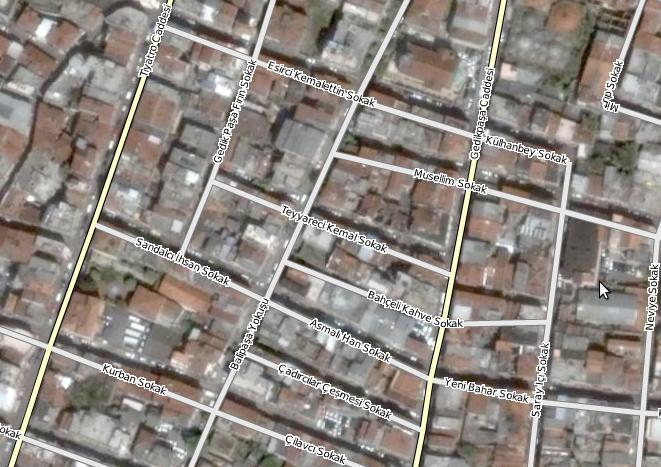
(http://image.bayimg.com/eabepaadb.jpg)
Is this because of misalignment of the Bing map? Because of sloppy editing?
My fingers are itching to correct these roads (but more with adding what is missing) - any ideas/guidelines on what to do to in this case?
It would be less than fun to move everything, and then realise it was wrong to do.
I'm waiting for some discussion before I start doing any moving of roads.
Happy mapping!
Discussion
Kommentar frå 0123456789, 2 desember 2010 kl. 21:24
You can't assume that the Bing imagery is the correct position, although in my area then with the Bing imagery agreeing with the Yahoo imagery and agreeing with the Ordnance Survey maps, then I am inclined to believe it is OSM that is wrong and correct it.
So use your judgement...
Kommentar frå Milliams, 2 desember 2010 kl. 21:51
Be sure to see how it compares with GPS traces. If there are numerous GPS traces in line with either the imagery or the ways then you know which is most likely correct.
Kommentar frå Dirbam, 2 desember 2010 kl. 23:52
You should align bing imagery to gps tracks. Best way is to find some street where is at least 4-6 tracks.
In some places Bing layer could have misalignement of 10-40 m. (yahoo imagery also has the same problem).
Kommentar frå z-dude, 3 desember 2010 kl. 01:09
ditto on what the above people said, the imagery may be off.
or, the streets may be off. They may be imported from a tracing based off of low resolution aerial photos.
Also realize that those street act as a canyon to your GPS signal, and you may be measuring a reflected signal rather than a direct signal from the satellite.
Best to align your imagery and tracks to GPS tracks in a clear unobstructed area, such as an open road in a field. Avoid cliffs, canyons and urban canyons.
Kommentar frå SamatJain, 3 desember 2010 kl. 03:21
There's evidence that Bing's imagery is off [my blog], at least at some zooms. As others have said, double-check with another resource (GPS tracks, Yahoo imagery, etc).
Kommentar frå liftarn, 3 desember 2010 kl. 09:12
It may differ on different zoom levels so that is an easy way to test it.
Kommentar frå Anna_AG, 3 desember 2010 kl. 10:18
I have just reviewed BING imagery in an area I know well and provided multiple GPS traces for ( osm.org/go/wHZ0etG-- ).
BING Imagery is out ( in Kaduna at least ) , so I would imagine it is out in other areas as well.
Unlike the WMS plugin, Slippy maps does not allow local alignment ( in JOSM at least )of the downloaded images from BING.
Is there going to be some work on this? It will be needed I suspect.
As a tip if you are not sure about alignment of imagery, have a look at the GPS traces ( in Potlatch or JOSM by downloading them ) and see how the imagery aligns to the GPS. If there is a noticeable error between the imagery and multiple GPS traces, it is likely the imagery has an offset.
bri
Kommentar frå halfd, 3 desember 2010 kl. 13:24
Thanks for all the suggestions!
It seems to me that it is a little of both, BING is off and the ways etc. are a bit off, so everything is just a bit off :)
But rather have something than nothing at all I think.
Before I wrote my question I took a look at the GPS tracks - in that specific area they look like a 3 year old has run amok with some crayons :)
Good point that alexz pointed out - get some readings from an open area.
Until I figure out what precisely is going on, I think I'll just do a lot of naming; then I get to go outside as well with my notebook - the weather is lovely in Istanbul at the moment.
Kommentar frå Zverik, 3 desember 2010 kl. 15:12
Use "imagery" plugin, it's a mix of slippymap and wmsplugin (and soon it will be integrated in josm core).