OpenStreetMap logo OpenStreetMap

lxbarth's Diary

Recent diary entries

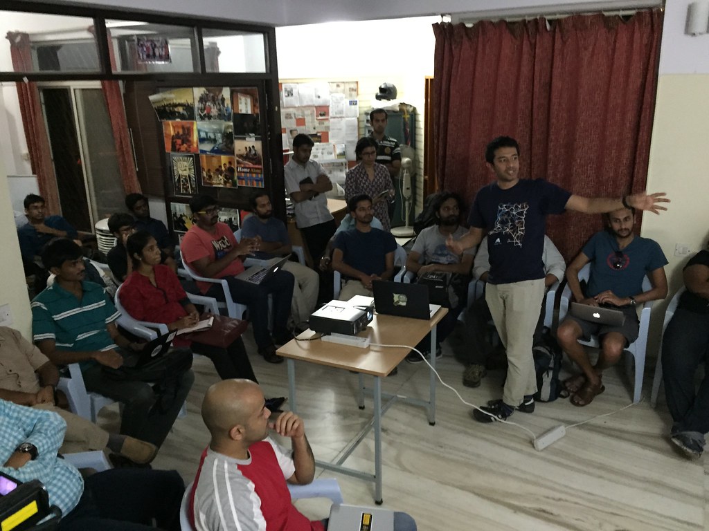
The energy at the first OpenStreetMap class in Ayacucho, Peru was amazing. We had about 40+ students come out to learn how to map. This is all part of our effort to build local community in this city of 150,000 in the Andes where Development Seed, (the company that launched Mapbox) was founded and where today we have a growing team of OpenStreetMap data analysts.

Read more about our goals for Ayacucho on our blog in English and on Ruben’s diary in Spanish.

OpenStreetMap class at the University of Ayacucho.

Location: Urbanización Cercado, Ayacucho, Province of Huamanga, Ayacucho, 05001, Peru

Bengaluru ♥ OpenStreetMap

Posted by lxbarth on 23 November 2014 in English.

I had a fantastic week in Bengaluru the amazing tech hub in India’s south with Shiv and Eric connecting with startups, NGOs, data geeks and geo community. We were part of an OpenStreetMap Geo BLR meetup and the #osmegeoweek mapping party and the turnout for both events was great. We had fun rigging rickshaws with Mapillary and we met inspiring mappers like PlaneMad and NGOs like Kalike mapping rural areas on OpenStreetMap.

Watch India, the map is growing fast! Good places to connect are the India mailing list, the Datameet Google group and in Bengaluru specifically, the GeoBLR meetup group

Geohacker presenting how the Moabi project uses OpenStreetMap software to track forest health in the Democratic Republic of Congo.

See full entry

Location: Fair Field Layout, Vasanth Nagar, Bengaluru, Bangalore North, Bengaluru Urban, Karnataka, 560001, India

OpenStreetMap this week in Bengaluru

Posted by lxbarth on 17 November 2014 in English.

If you’re in Bengaluru this week, here are two events you shouldn’t miss:

I will be at both events with my colleagues Shiv and Eric - looking forward to catching up!

On Lazar Road heading towards Coxtown Circle, Bengaluru

Location: Lazar Layout, Frazer Town, Bengaluru, Bangalore North, Bengaluru Urban, Karnataka, 560005, India

Attendees of State of the Map in Buenos Aires this weekend may have noticed how Buenos Aires’ villas de miseria - poor precarious neighborhoods - are well mapped on OpenStreetMap.

It’s a great example of how OpenStreetMap enables citizens to just create the map they need: The initiative Caminos de la Villa holds government accountable for public services in low income neighborhoods. The problem was, when the program started, Buenos Aires’ villas weren’t on any digital map. So the teams behind Caminos, the Argentinan technology non-profit Wingu and the social justice group ACIJ rallied a group of locals and put five villas with a total of 27,000 families on the map.

Over the course of 6 months they spent a total of three weeks tracing and surveying the five villas. The result is 638 ways and 102 points of interest added. This was tremendously useful work done in an incredibly short amount of time.

See full entry

Location: Villa 21-24, Barracas, Buenos Aires, Comuna 4, Autonomous City of Buenos Aires, Argentina

The trouble with the ODbL - summarized

Posted by lxbarth on 28 October 2014 in English.

Kevin Pomfret from the Centre of Spatial Law just published The ODbL and OpenStreetMap: Analysis and Use Cases a white paper reviewing pain points in the ODbL - OpenStreetMap’s current license.

2.5 billion OpenStreetMap nodes!

The paper provides a comprehensive review of issues broached in talks at State of the Map US (More Open, OpenStreetMap Data in Production) and State of the Map EU (The State of the License) and discussions thereafter. It offers an assessment of legal risks and includes a series of case studies focusing on legitimate use cases of OpenStreetMap that are currently impeded or complicated by the ODbL. At both State of the Map conferences I have heard requests from the Licensing Working Group, the OpenStreetMap Foundation board and others for a more solid summary of problems and actual real world use cases that are impeded by the license. This is why over here at Mapbox we have supported the Centre of Spatial Law to compile this white paper.

See full entry

The annual open data conference AbreLatam / Condatos last week in Mexico City gathered for the first time the Latin American OpenStreetMap community. The OpenStreetMap track Conmapas connected people who’ve been working alongside in Latin America virtually for sometimes more than five years, and also drew in a huge crowd of city planners, activists, hackers, and map lovers who came to learn everything about OpenStreetMap.

This was a highly timely event in a year with heightened activity in Latin America’s OpenStreetMap community and just a month from the annual OpenStreetMap conference State of the Map this year to take place in Buenos Aires from November 7th - 9th.

Here are some highlights of the event:

The morning was all talks and a panel about the growth of OpenStreetMap. We spent the afternoon with workshops and hacking on maps, editing OpenStreetMap, map making and opening data. You can read up on the full #conmapas program on the conference web site.

See full entry

Location: Santa Cruz Atoyac, Mexico City, Benito Juárez, Mexico City, 03310, Mexico

Vote today. OpenStreetMap US elections are open now. You can vote until October 12th. If you are an OpenStreetMap US member, you have a ballot in your inbox. If you’re not you can become one in minutes and still vote.

I’m running for re-election to the the OpenStreetMap US board to expand OpenStreetMap US as a convening organization for everyone.

Over my past two years on the board, we have doubled the size of the State of the Map US conference, expanded its appeal to non-traditional audiences, increased diversity with scholarships and a distinct cross-audience appeal, and supported over 70 mapathon events that you all have helped organize.

OpenStreetMap is about the combination of the community: individual mappers and businesses and the humanitarian community and governments. We will succeed even more if we make an even more open community for everyone to collaborate. Working with Martijn, John, Jim, Kathleen, Mele, and Ian has been incredibly rewarding and I’d like to continue this into a third year.

To create a better map, we need to continue to expand OpenStreetMap beyond its current limits to communities we’re not talking to yet. We need to bring OpenStreetMap to a broader set of industries, organizations, and communities. This is also the key for creating more diversity in terms of gender, global presence and ethnicity. To become more diverse as a community we have to grow in numbers.

See full entry

The Mapbox OpenStreetMap Data Team Guidelines

Posted by lxbarth on 19 September 2014 in English. Last updated on 13 October 2014.

Earlier this week Danny and Richman joined our growing data team. Alongside Ruben, Edith and Luis they will help us here at Mapbox contribute even more and better improvements to OpenStreetMap. With our data team up to five full-time members, we can redouble efforts on projects like tracing all of San Francisco’s buildings, fixing massive amounts of TIGER misalignments and importing 1 million New York City buildings. This is a huge step up in our ability to contribute data and give back directly to the community. To make this work, we’re creating public guidelines that ensure our involvement is positive for OpenStreetMap as a community and as a map.

Updates to TIGER roads in US by Mapbox data team

In addition to the rules that apply to everyone in the community, here are the guidelines we want to reiterate and add for ourselves:

See full entry

As of June, New York City buildings and addresses have been fully imported to OpenStreetMap. While we are tackling remaining cleanup tasks I wanted to share a full recap of the effort. I am very happy with the overall result. There are lessons to be learned here from what went well but also where we could have done better - read on for the details.

More than 20 people - volunteers and members of the Mapbox team - spent more than 1,500 hours writing proposals, discussing, programming, uploading, processing and reviewing. Between September 2013 and June 2014 we imported 1 million buildings and over 900,000 addresses. We fixed over 5,000 unrelated map issues along the way.

Here are screenshots of the resulting work:

Building coverage on Manhattan island, the southern tip of the Bronx to the northwest and Wards island to the right.

====

See full entry

Location: Manhattan Community Board 3, Manhattan, New York County, New York, United States

We’ve completed work on the San Francisco building footprint dataset. We added or modified over 150,000 buildings in about 5 months of tracing with a team of three. My colleague Ruben just posted stats on the Mapbox blog. Here’s an animation of all changes.

Location: Civic Center, South of Market, San Francisco, California, 94102, United States

Connecting Communities With Improved OpenStreetMap Credits on Mapbox Maps

Posted by lxbarth on 10 May 2014 in English. Last updated on 10 June 2014.

We’re updating attribution for OpenStreetMap-based Mapbox maps thanks to feedback on attribution conventions here on the diary and on mailing lists. The new convention on Mapbox maps is to expand attribution by default: collapsed attribution should only be used when attribution becomes unusually long, or screen space is limited. Expect us to roll out these changes over the next couple of weeks, but here is a preview right away.

The entire goal of the Mapbox team’s work with OpenStreetMap is to help make OpenStreetMap the best map, everywhere in the world. We will only be able to achieve this as a community and with open data. Linking maps back to OpenStreetMap is at the heart of growing OpenStreetMap by helping turn map consumers into map contributors. Our goal with these new attribution conventions is only to further improve the connection of the many million users who view Mapbox maps every day to OpenStreetMap.

Here are the new attribution recommendations for all Mapbox maps that are based on OpenStreetMap data.

Expanded attribution

While collapsed attribution wrapped in an info - ⓘ - symbol, works well on small screens, we are now recommending to expand attribution whereever possible. The full attribution line is “© Mapbox © OpenStreetMap” and next to it we recommend an “Improve this map” link leading a user to editing on OpenStreetMap. Another change is that now “© OpenStreetMap” links directly to osm.org/copyright, “© Mapbox” continues to link to http://mapbox.com/about/maps listing the full roster of map data we’re using including OpenStreetMap.

See full entry

Attributing OpenStreetMap

Posted by lxbarth on 30 April 2014 in English. Last updated on 10 May 2014.

Updated attribution recommendations for Mapbox maps: osm.org/user/lxbarth/diary/21847

Showing how OpenStreetMap is a living map, and making it easy to start mapping is the first step to turn someone from passively looking at a map into improving the map. It’s part of spreading the word and building our community. At Mapbox we power OpenStreetMap based maps to hundreds of millions of people, and this gives us a unique opportunity to connect them to OpenStreetMap and turn people from being passive map consumers into active map contributors. Driving contributors to OpenStreetMap is a key goal we pursue not only with attribution but also in our aggressive launch communications around prominent new customers.

Our goal is to feature OpenStreetMap to help grow the community - attribution plays a key role in this.

Attributing OpenStreetMap based Mapbox maps

For the web, at Mapbox we recommend the following two variations for attributing OpenStreetMap:

See full entry

This weekend, the quarterly US #editathon takes place in 10 US cities - read all about it on the OpenStreetMap US blog.

The #editathons are not just a great excuse to meet up with other OpenStreetMappers to push on projects, but also an opportunity to learn more about OpenStreetMap. In DC we’ll be hosting the #editathon in the Mapbox garage. It’s going to be great weather so expect some people to go outside and survey too. Read up on the Mapbox blog on how to find the Mapbox garage. Here’s a photo from last year’s event there:

Location: Logan Circle/Shaw, Ward 2, Washington, District of Columbia, United States

Hal Hudson from New Scientist wrote a great article on how OpenStreetMap helps Médicins Sans Frontières (MSF) fight Ebola in Guinea:

Online army helps map Guinea’s Ebola outbreak

He reports:

WHEN doctors working for Médecins Sans Frontières (MSF) arrived in the West African nation of Guinea last month to combat an outbreak of the deadly Ebola haemorrhagic fever, they found themselves working in an information vacuum.

MSF enlisted the help of the Humanitarian OpenStreetMap team (HOT) and within a few days, a huge number of mappers flocked to OpenStreetMap, putting the affected areas on the map. Where existing Bing imagery was not sufficient, Astrium and DigitalGlobe provided fresh takes.

Few days into the crisis Pierre Béland from the Humanitarian OpenStreetMap team shared numbers of this effort on the mailing list:

Even if this crisis is not in all the medias, the contribution from the OSM contributors is fantastic. In 8.5 days, 302 contributors, 1.2 million objects, 114,000 buildings, 5,000 places and 6,100 landuse polygons.

The New Scientist article explains how OpenStreetMap helps fight the virus:

Mathieu Soupart, who leads technical support for MSF operations, says his organisation started using the maps right away to pinpoint where infected people were coming from and work out how the virus, which had killed 95 people in Guinea when New Scientist went to press, is spreading. “Having very detailed maps with most of the buildings is very important, especially when working door to door, house by house,” he says. The maps also let MSF chase down rumours of infection in surrounding hamlets, allowing them to find their way through unfamiliar terrain.

Since the response to the Haiti earthquake we are now seeing time and again how OpenStreetMap is facilitating incredibly mapping of badly needed geo data, helping first line emergency responders do their work.

You can’t do this with any other map but OpenStreetMap.

See full entry

Cross posted to talk list

Effective immediately the Mapbox Satellite option in iD and JOSM is 100% open for tracing in OpenStreetMap, including all our high resolution DigitalGlobe imagery. This is full coverage down to zoom level 19 imagery in the US + Western Europe and world wide to zoom level 17.

To use this imagery select “Mapbox Satellite” from the imagery menu in iD on the web or in JOSM. Mapbox Satellite is open for tracing in OpenStreetMap in general and not tied to a specific editor, so if you would like to add Mapbox Satellite to another OpenStreetMap editor you are welcome to do so.

This is a big affirmation of DigitalGlobe’s commitment to provide imagery for OpenStreetMap (also Bing imagery contains to a very large degree DigitalGlobe material). Props to Kevin Bullock and our friends at DigitalGlobe - it’s fantastic working with good people who see wins of working with OpenStreetMap.

Digital Globe announcement

See full entry

OpenStreetMap is published under a share-alike license, the so called Open Database License (ODbL). The license says that if raw OpenStreetMap data is mingled with raw third party data, and the result is used publicly, you are required to release the result under the same ODbL. This is, in short, the share-alike principle under which OpenStreetMap data is available today - under certain circumstances, it extends the license of OpenStreetMap data to data sets it’s mixed into.

Sounds like a great idea at first, right? You’re promoting the idea of opening data by making sure anyone who uses your data opens their data too. Well, there’s a big gotcha: we wind up more often with OpenStreetMap not being used rather than with previously closed data opened up. This in turn hurts the project which thrives on increased adoption.

Photo: Alan Levine

See full entry

Share what you’ve been working on, or present your vision for OpenStreetMap at this year’s State of the Map US in Washington DC April 12 - 13.

You have until February 2nd (this Sunday) to submit your session.

You’ll find the submission form here: http://stateofthemap.us/

Looking forward to hearing from you.

Presentations at State of the Map US 2013. Photo: Justin Miller.

This is an update on the ongoing import of New York City buildings and addresses. For background read up on New York City and OpenStreetMap cooperating through Open Data

At our kick off session past month in New York City, we’ve discovered issues with the data conversion that are fixed now and the import is ready to start over again.

We have taken the time to take a close review of existing uploads. Here are some issues we’ve found that are worth highlighting as we restart the import.

  • Make sure every upload to OpenStreetMap completely validates and all critical warnings are resolved before you update.
  • Critical warnings are at least any warnings or errors that stem from
  • Buildings overlapping with buildings
  • Buildings overlapping with other features they cannot overlap with such as roads
  • Resolve not only buildings duplicate with existing buildings but also addresses duplicate with existing addresses
  • Merge point of interest information from existing nodes to new buildings when they clearly building-level such as schools, fire houses, super markets, etc.

To get started head over to the tasking manager carefully (re) read instructions and grab a task.

Make your life easier and get these JOSM styles for buildings and addresses by emacsen. They’ll allow you to see issues with the data better. Learn how to install them in JOSM docs.

If you have any questions, fire away here on the comment thread.

Location: Manhattan Community Board 3, Manhattan, New York County, New York, United States

On the imports list I recently raised the question on whether to tag addresses on buildings ways or not. Specifically, if there is only one address for a given building polygon, should the address tags sit on the building’s ways or should the address tags sit on a separate node within the building? Obviously, if there is more than one address per building, there is no other way but mapping them as nodes separate from the building way.

Eric Fischer just ran an analysis to figure out what is actually the current convention in OpenStreetMap. Here’s the short answer: addresses are tagged on building ways where possible. By a wide margin.

Read on for the numbers.

Address tagged on building ways (left) is the more common approach in OpenStreetMap versus address tagged on a separate node (right).

The rough numbers break down like this:

See full entry

Last Saturday we officially kicked off the NYC building and address import with a community session hosted by OSM-NYC and Public Labs at the Pfizer building in Brooklyn. The goal was to get the local NYC OSM community involved in this large data undertaking and at the same time harden our import process.

Over 20 people attended, and we knocked out 158 of the over 5000+ sub-tasks total. Both turn out and tasks accomplished were great and exceeded what I expected for a casual Saturday afternoon event.

progress-nyc

We’ve also discovered an address formatting issue and a geometry conversion issue that put the import on hold until they are addressed.

Working through this import we’re learning very interesting lessons:

See full entry

Location: Williamsburg, Brooklyn, Kings County, New York, 11249, United States