
Recently, I’ve been trying to move tags on island nodes to its way (natural=coastline) following the best practice of One feature, one OSM element. The original place=island nodes were from an GNS import. Most of these islands now have a digitized coastline so it makes sense to add the place=island and all its tags to the ways.
To do this, I ran an overpass query to get all place=island nodes within a given boundingbox. Code is below:
<osm-script output="xml" timeout="25"><!-- fixed by auto repair -->
  <union>
    <!-- query part for: “place=island” -->
<query type="node">
  <has-kv k="place" v="island"/>
  <bbox-query s="4.061535597066106" w="111.57714843749999" n="21.166483858206583" e="127.11181640625"/>
</query>
</union>
<!-- print results -->
<print mode="meta"/><!-- fixed by auto repair -->
<recurse type="down"/>
<print mode="meta" order="quadtile"/><!-- fixed by auto repair -->
</osm-script>
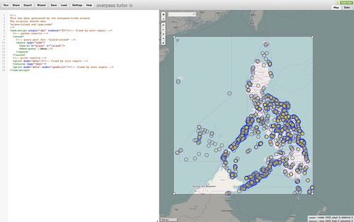
The result will show on the map like this:
Then, I clicked the “Export” link to download the data into JOSM.
Slowly, working my way on each island node, I transferred the tags to the coastlines. If there is no natural=coastline, I trace them using Bing’s high-res imagery and then add the tags in the island nodes.
Right now, I’m focusing my efforts on smaller islands where the natural=coastline is on a closed way. I will start working on the islands relations once I finish the closed ways. Might take a while though (current count is ~2,500 nodes).
Discussion
Puna mula sa 4rch noong 13 Pebrero 2014 sa ganap na 13:48
Good work!