
Last weekend, a couple of OSM volunteers and drone enthusiasts visited Lupang Arenda in Taytay, Rizal. The visit was part of the ongoing collaboration with Barangay Santa Ana in Taytay to use OpenStreetMap as one of their tools for managing community initiatives. The origins of this collaboration has an interesting back story but I won’t talk about it on this post. ;)
The main goal of the visit is to capture images using drones to create an updated aerial imagery of the community to identify individual building/houses. For a densely populated community like Lupang Arenda, it is difficult to get this level of detail using satellite imagery.

The crew. Photo by Erwin Olario.
After a few minutes of mission planning, we split the group into 3 teams. 2 teams deployed drones to capture overhead photos and 1 team installed action cams to the barangay vehicles to collect street-level photos. The drone team flew 5 times covering ~82 hectares or half of the whole community. After the collection, we then processed the drone imagery using OpenDroneMap to create high-resolution orthophoto.

Coverage of captured imagery

Processed orthophoto and building outline from OpenStreetMap based on outdated satellite imagery.
The level of detail we captured are amazing! Aside from the original intent of using this imagery to update the building outline of individual houses, the imagery also reveals key community issues. Here’s a couple I was able to identify with just a quick pan and scan.

Expansion of settlement continues towards the remaining wetlands of Laguna Lake.

New structures under construction.

Abandoned buildings which may require update of the barangay household survey database.
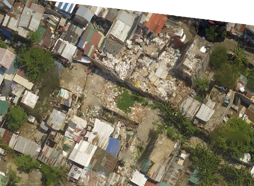
Debris and garbage blocking access to some roads.


Localized flooding due to blocked drainage canals.
These are just a few spots I saw with a quick browse. We are very excited share back the output to the partner community and understand better how they will use the data. Imagery is now available at OpenAerialMap for anyone to use.
We are still not done, we will cover the other half of the community in future visits. Huge thanks to Bunny, Ian, Buboy, Leigh and Rally for volunteering a weekend of their busy schedule to doing this. Also thanks to Erwin, Kath and Marriane for organizing the activity.
讨论
arnalielsewhere 于 2019年07月 9日 05:25 的评论
Cool! :D
kucai 于 2019年07月 9日 08:54 的评论
Wow!
One question. Does that OpenDroneMap fully utilize multi core cpus?
Alan Bragg 于 2019年07月 9日 21:08 的评论
Nice work. I hope some enthusiasts follow your advice.
GOwin 于 2019年07月10日 08:27 的评论
@kucai
Yes, ODM can use multi-cores
PlaneMad 于 2019年07月13日 10:57 的评论
This is amazing, and super relevant for most of the world where communities need to figure out solutions for themselves.
One interesting thing that also seems to be captured is the web of communications cables draped over the buildings.
It would be really cool to have an IR camera and have a high resolution thermal imagery. Maybe useful for vegetation health?
muzirian 于 2019年07月15日 07:57 的评论
wow this is nice, thanks for sharing.