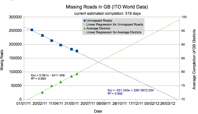
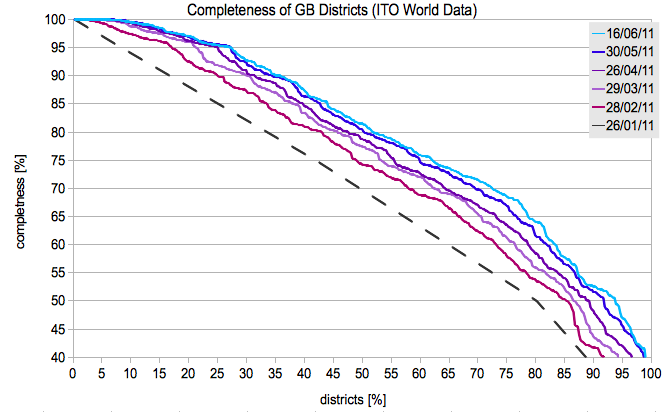
I have updated my statistics that I generate from the ITO world comparison with the OS Locator data set. If you look at the graphs we can see an impressive decrease of unmapped roads. Unsurprisingly, a lot of districts have reached completion - with over a quarter now at 95%!
However, the addition speed of unmapped roads has decreased over the recent months. So there is still 319 days left at current speed. So, keep mapping.
osm.wiki/w/images/f/f8/GB_stats.png
osm.wiki/w/images/0/02/GB_complete.png
討論
由 chillly 於 2011年06月20日 16時17分 發表的評論
The ITO world only shows comparisons of the names from OS Locator and those on the ground. Many of the roads already exist on the OSM database, but the name is different from the OS Locator data. Having a road in the database is very useful, having its name is good too, having all of the extra details around the road that are not mentioned in the OS Locator dataset is what really makes the difference. To me one of the best uses of the OS Locator data is to highlight the newly added stuff in each new version. It shows up the places that need a new survey because something has changed.
由 smudge 於 2011年06月20日 18時44分 發表的評論
This reminds me - is there an easy way for me to know (other than local knowledge) where the unmapped roads are in the UK. IE where I should go to next?
由 mannequinZOD 於 2011年06月21日 09時51分 發表的評論
@chilly: Fair point. When I compared OSM with OS Locator data, I find most roads (except small courts) already in OSM, but the names are missing. For navigation missing road names can be a problem thou.
@smudge: click on one of the less mapped regions http://www.itoworld.com/product/data/osm_analysis/main
e.g. http://www.itoworld.com/product/data/osm_analysis/area?name=Easington
由 marscot 於 2011年06月22日 18時45分 發表的評論
I had my area at 100% and now they have built a few more roads, time for a few new trips into the unknown.