If you ever wanted to know what Cambridge, UK was all about....
Дасланы mannequinZOD 17 Кастрычнік 2013 на English.Impressive coverage of academic institutions…
Impressive coverage of academic institutions…
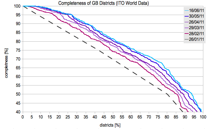
Had a look recently again at the UK road completeness stats in OSM. Impressive progress, congrats to everyone who has left his/her mark on the map
http://www.itoworld.com/product/data/osm_analysis/main
compare my 2 year old stats osm.wiki/w/images/0/02/GB_complete.png
The FAZ uses OSM maps from Oslo and surrounding in one of their recent articles about the bloody attacks in Norway
http://www.faz.net/artikel/S30190/doppelanschlag-norwegen-trauert-30472141.html
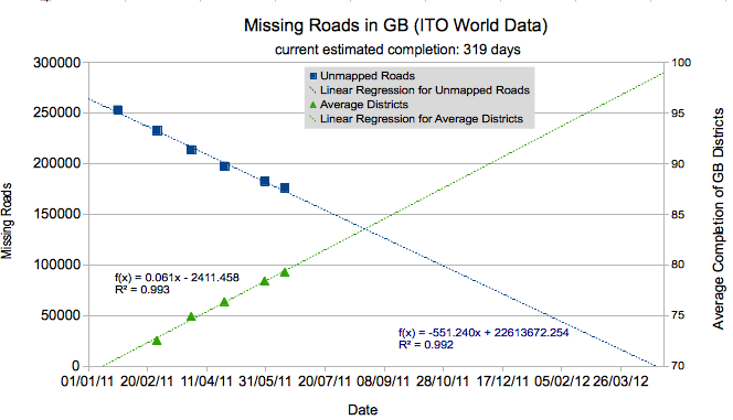
I have updated my statistics that I generate from the ITO world comparison with the OS Locator data set. If you look at the graphs we can see an impressive decrease of unmapped roads. Unsurprisingly, a lot of districts have reached completion - with over a quarter now at 95%!
However, the addition speed of unmapped roads has decreased over the recent months. So there is still 319 days left at current speed. So, keep mapping.
osm.wiki/w/images/f/f8/GB_stats.png
osm.wiki/w/images/0/02/GB_complete.png
Recent ITO world data shows that the current mapping speed is 665 roads/day fixed or added. Assuming that the current mapping speed is kept up, this means the complete road network will be finished in 313 days. Less than a year to go.
(100% complete == all roads from the British government Ordnance Service are present and correctly named)
osm.wiki/w/images/0/02/GB_complete.png
also check out the Completeness of Roads and the changes in single districts
osm.wiki/w/images/f/f8/GB_stats.png
-------------
Historic overview of the data from ITO World
http://www.itoworld.com/product/data/osm_analysis/main
also see their blog entry from January
http://itoworld.blogspot.com/2011/01/some-graphs-relating-to-openstreetmap.html
can't wait for the next...
Can someone with more knowledge please check this out and block / revert it. I saw that the river bank was broken and tried to fix it, but it also looks like someone went wild on the roads.
osm.org/?lat=55.717&lon=37.5749&zoom=14&layers=M
Hallo,
I have been monitoring POI development for Europe and Germany for fun. I use the POI exports provided by cloudmade and count some selected POI's and look at the development over time. Unfortunately, cloudmade does not provide any POI exports for Europe anymore, so new data only contains German POI development. Interestingly, there is a trend of fewer and fewer POI additions recently. It could be possible that the German community gets tired of mapping, but I don't think that this is the case. I hope my stats don't have errors, but is it possible that most POIs in well mapped areas have been mapped and we are seeing a saturation effect? This would be great news and indicates that OSM reaches a new level of maturity.
the graph:
osm.wiki/File:OSM_DE_Europe_stats.png
Random POI's monitored:
Cafe
Pub
Restaurant
Fast Food Restaurant
Beer Garden
Parking
Fuel
Hospital
Veterinary
Pharmacy
Attraction
Playground
Zoo
Cinema
Fountain
Picnic Spot
Nature reserve
Common
Hotel
Hostel
Guest House
ATM
Bank
Taxi
Commercial
Soccer
Swimming
Gymnastics
Sports Center
Pitch
Skateboard
Rowing
Table_tennis
Tennis
Multi sport
Equestrian
Golf
Shooting
Archery
Climbing
Boules
Soccer
Camp site
View point
Peak
Car rental
Tower
Museum
Spring
Nokia responded the googles free online GPS navigation in the US with free online/offline navigation in 180 countries
http://www.reuters.com/article/idUSTRE60K0YZ20100121
What will be the impact on OSM? Are people less inclined to use free OSM data with their navigation software?
A new year, more than 200 000 user accounts. A good start!
I have updated my POI statistics for Europe and Germany. Just follow the link or go to the OSM wiki stats page.
http://jef-hd-ma.freehostia.com/uploaded_files/POI_statistics_EU_D.html
The data comes from cloudmade's POI.gpx files and is extracted with a simple bash script. I am happy to pass it on in case someone is interested
I have assembled some POI statistics for Europe and Germany. The idea is to track development over the next couple of weeks/months. Just follow the link or go to the OSM wiki stats page.
http://jef-hd-ma.freehostia.com/uploaded_files/POI_statistics_EU_D.html
The data comes from cloudmade's POI.gpx files and is extracted with a simple bash script. I am happy to pass it on in case someone is interested
UPDATE (7/12/09): There is an error in the calculations. It only counts POIs with names. I will update it tonight
Cleaned up more than a 100 mapping errors (only missing junction nodes) in the Cambridge, UK area, one of the 'better' mapped places. There are still plently left further outside the city.
Look at http://keepright.ipax.at/ and display all junction errors in your neighbourhoor. You will be surprised. The rendered map might look quite nice already, but it's ugly underneath
OSM lacks behind other map services with Routing capability, because a lot of nodes lack connections. Many users are not aware of these issues. Better advertisement of tools like http://keepright.ipax.at could significantly improve map quality. Maybe it should be one of the default map layers?
More than 1 000 000 000 Gps data points and more than 400 000 000 nodes !!!