
OpenStreetMap: where should the next recruitment drive be?
ایہہ 9؍January 2013ء English وچ «mcld» لیکھ چھپیا گیا سی۔Here’s a data-driven way to decide where the next OpenStreetMap recruitment drive should be. Take the geographical spread of edits in 2012, and divide it by the geographical spread of the population, to see where there are most/least edits “per person”:
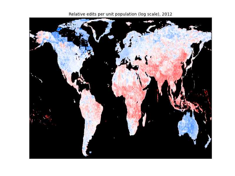
More details on my blog article about it.
Discussion
ایہہ 15؍January 2013ء 06:55 تے «phil3nix» ٹپݨی کیتی گئی سی۔
Nice graphic.
I actually just downloaded a bunch of data for a motorcycle trip through Mexico in about a month. I was surprised at the level of detail that exists in the open street map.
Will try to take as many GPX tracks as possible while on the road. ;-)
ایہہ 3؍October 2014ء 22:09 تے «Stalfur» ٹپݨی کیتی گئی سی۔
Just found this via your comment on my little manually created map of Iceland. In summer 2013 I mostly finished my home town in Iceland and decided to “adopt” a country in Africa which needed lots of work. In the end I decided on Botswana which is sparsely populated but fairly large.
The Mapping Botswana project is now a year old and slowly gaining local momentum, there are challenges to creating a local base from 10 000 km distance but social media and finding contacts is edging us closer.