
Download along my own virtual way in Overpass API
Publicat per mmd el 12 Agost 2017 en English. Última actualització de 2 Maig 2018THIS FEATURE IS NOW OFFICIALLY AVAILABLE IN OVERPASS API 0.7.55
Again a bit of prototyping today.
I always wondered what the best way to download all objects along some GPX track (more generally a list of lat/lon pairs) in Overpass API might be.
Usually, you don’t want to create some complex poly-filter for this, or even worse upload your gpx track as OSM way just for the sake of finding out what’s close by.
You might have come across the around filter, which comes in handy to find objects around a center point. I have extended this idea a bit to also handle linestrings.
Here’s a first result: a turquoise circle in the middle is our great made up GPX track, consisting of about 20 points. All the yellow stuff in the background is what Overpass API returned as highways up to 500m away from our circle. Obviously, that circle doesn’t exist in OSM, so we’re really looking at what’s close to our virtual way.
Circle

Live demo: http://overpass-turbo.eu/s/yt2
Road trip
Imagine you want to create a map with only minimum features (motorways, some important nodes), and some place names along your own lat/lon pairs. Here’s an example for such a trip from Frankfurt to Basel, downloaded as 10MB PBF file, processed via osm2pgsql and rendered by Kosmtik:
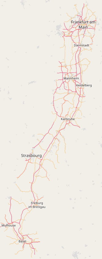
Live demo: http://overpass-turbo.eu/s/qXI
Github issue: https://github.com/drolbr/Overpass-API/issues/418
Discussió
Comentari de Polyglot el 17 Agost 2017 a les 07.18
It would be stupendous if that could be integrated into JOSM.
Jo
Comentari de mmd el 18 Agost 2017 a les 12.09
Well, I guess this needs to be merged into the official Overpass API branch first. So far, this is only in my own personal branch and not part of the official release.
Comentari de santamariense el 18 Agost 2017 a les 22.01
Perfect to download objects for mapping bus lines.
Comentari de Multigon el 20 Agost 2017 a les 10.55
https://josm.openstreetmap.de/wiki/Help/Menu/GPXLayer
@Polyglot: JOSM does support this for a long time, although the online help spares out a separate page about the download action.
Comentari de mmd el 20 Agost 2017 a les 11.00
JOSM indeed supports downloading along a gpx track, but it would do so by downloading all data in a number of smaller bboxes rather than the data you’re only interested in.
Comentari de Multigon el 21 Agost 2017 a les 07.18
I did not post it to diminish your work, just to update Polyglot.
Personally I’ve used overpass-turbo to remote control and import data into JOSM, which worked marvelously, as long as the metadata is included. My guess is that this will continue to work with your update to overpass api, so the need to duplicate this functionality in JOSM is weak.