biggest mobility quest solved: All Roads to rome - made with GraphHopper and OSM
於 2015年十二月 9日 由 moovellab 以English發表。Roads to Rome
During the last couple of months we worked on solving one of the biggest mobility quests: Do all roads lead to rome? -> roadstorome.moovellab.com
All maps were made with great tools & open data! graph hopper, osm, mapbox, morganherlocker, nodejs, leaflet, mongodb
Roads to Rome
So we have our destination: Rome. But where do you start to find all roads to Rome? For this we created a square grid that covers all of Europe. Every cell of the grid contains the starting point of one route. Next step was combining all 500k routes on one map. For this we aggregated the number of times every street segment was used in the routes. Following this count we created this map:

Roads to US Romes
Continuing on the thought of finding all ways to Rome we set off to the USA: We actually found 10 cities named Rome. This posts a new problem: we don’t have one destination but 10. Starting points are still spread in a grid covering the US. So from every starting point, we searched for the closest of the US Romes. That solves that. Now we color keyed every rome and out came a map, that shows the closest rome to every location in the US:

we continued on the territorial thought, check out more maps here: (roadstorome.moovellab.com)
Urban Mobility Fingerprint / Street DNA
Since we covered the large scale, we continued on a small scale city level by introducing the Mobility Fingerprint and DNA
Creating a N-to-1 Route also works for the city. In our visualisations we created an isochrone of 15min keeping the routes displayed from all segments calculated.
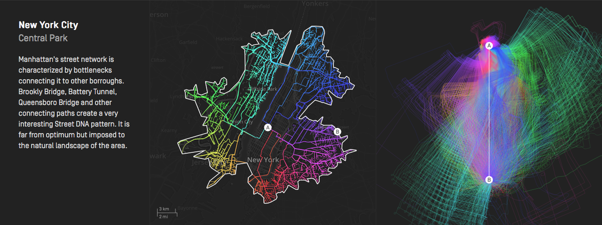 1. Routes are coloured according to their compass direction.
2. Routes are rotated so that they align north to south.
3. Routes are scaled to match start and destination points
1. Routes are coloured according to their compass direction.
2. Routes are rotated so that they align north to south.
3. Routes are scaled to match start and destination points
Basically the DNA shows the deviation from the ideal path from A to B aggregated with all routes.
I’m really looking forward to your comments. Check our the whole project here: roadstorome.moovellab.com
討論
由 pratikyadav 於 2015年12月10日 07時42分 發表的評論
This is so awesome.
Great work.
由 Endres Pelka 於 2015年12月10日 13時25分 發表的評論
“502 Bad Gateway”
由 moovellab 於 2015年12月10日 13時43分 發表的評論
Thanks for your enourmous feedback! You’ve exceeded our and our server’s expectation! We’re working on fixing the Urban Mobility Fingerprint and Street DNA as soon as possible!
由 PlaneMad 於 2015年12月11日 09時01分 發表的評論
Beautiful work!