mvexel's Comments
| Post | When | Comment |
|---|---|---|
| Creating a quick Survey Kit with Overpass Turbo | RobJN, thanks for the StreetComplete reminder. I do know that app. I don’t have an android phone currently, but it’s a great option for those who do. |
|
| Creating a quick Survey Kit with Overpass Turbo | Or rather, this (forgot one |
|
| Creating a quick Survey Kit with Overpass Turbo | Thanks mmd! I was hoping for a quality Overpass tip to improve the query :) Like this ? |
|
| OpenStreetCam sign detection code and training data open sourced | Also, interestingly, someone on hacker news pointed out that the example image highlights a sign for an exit speed limit, not the main road speed limit :) This to prove the point that this kind of technology a) needs improvement, so it can only benefit from being open source and b) the results will need the crucial human mapper eye to be useful for OSM. |
|
| OpenStreetCam sign detection code and training data open sourced | Yes, thanks for adding that, edited the post with the link. |
|
| OpenStreetCam sign detection code and training data open sourced | The Android app is open source pizzaiolo, have you looked into submitting a pull request? It’s on the team radar I know, but just haven’t been able to make it a priority. |
|
| Missing Roads from ImproveOSM now also on MapRoulette | GOwin, I’ll work on that! |
|
| New version of OpenStreetCam JOSM plugin with sign detections | I also posted this on the Improve OSM blog. |
|
| New MapRoulette beta | Beta 4 is out in the mean time. Release notes. |
|
| New MapRoulette beta | We had a disk space issue…Should be solved now. Thanks for reporting! |
|
| OSMCha News - January/2018 | I agree that it could be improved, but I do think that it is a move in a good direction and will encourage especially new users by making them feel part of the community. Some improvements I can think of..
On the OSM server side you should be able to opt out of emails, perhaps this is already possible, but if not it should be. |
|
| OSMCha News - January/2018 | Great work on this tool, Wille. |
|
| How to create a translation file to convert a shp file to osm | Obviously but very importantly:
The Cygnus web interface links to my diary entry that points out these things in big capital letters, but it cannot be stressed enough! |
|
| Trunk in a funk | Hi all, Thanks a lot for your thoughtful responses. Here’s a followup I just posted to talk-us:
|
|
| Trunk in a funk | Yea, the OSM wiki actually has 40 MPH which perhaps makes more sense. Living in a rural state where speed limits are up to 80 MPH colors my thinking I guess. |
|
| Mapping turn lanes in OpensStreetMap | Another new diary entry that is related to this topic: Mapping Center Turn Lanes in the United States |
|
| OpenStreetMap US Mappy Hours Reboot | Yes, thanks, corrected. |
|
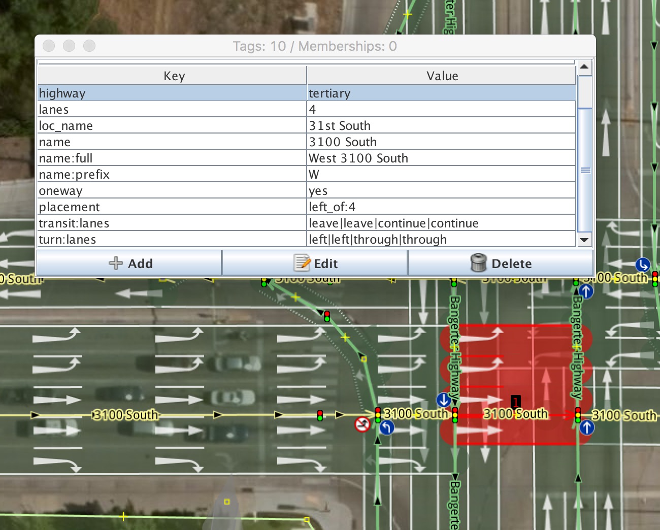
| How would you map this? | escada: I’ve seen
It looks like 1-2 can be done with ways, as indicated below, but I am not sure how to identify that the left turn lanes from 2 to 3 lead to the left two lanes of segment 3.
|
|
| Mapping turn lanes in OpensStreetMap | My recent diary entry with a ‘mapping challenge’ for a complicated intersection is relevant to this topic. I’d appreciate your feedback! |
|
| How would you map this? | Wow, thanks for all the feedback. I am happy to see people seem to prefer the One thing that would still lead me to want to use relations in some places is my second ‘requirement’ to correctly identify lane connectivity – exactly which (turn) lanes connect to which. So how to map that making a left turn here (1->2->3)
means that you have to go from lane to lane on the consecutive ways like this:
For that you would still need a relation, or is there a simpler / other / better way? |